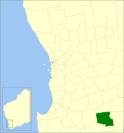
Shire of Broomehill-Tambellup
| Shire of Broomehill-Tambellup Western Australia | |||||||||||||
|---|---|---|---|---|---|---|---|---|---|---|---|---|---|
 Location in Western Australia | |||||||||||||
| Population | 1,167 (2013 est)[1] | ||||||||||||
| • Density | 0.44728/km2 (1.1585/sq mi) | ||||||||||||
| Established | 2008 | ||||||||||||
| Area | 2,609.1 km2 (1,007.4 sq mi) | ||||||||||||
| Shire President | Garry Sheridan | ||||||||||||
| Council seat | Tambellup | ||||||||||||
| Region | Great Southern | ||||||||||||
| State electorate(s) | Wagin | ||||||||||||
| Federal Division(s) | O'Connor | ||||||||||||
 | |||||||||||||
| Website | Shire of Broomehill-Tambellup | ||||||||||||
| |||||||||||||
The Shire of Broomehill-Tambellup is a local government area in the Great Southern region of Western Australia, 320 kilometres (200 mi) south-southeast of the state capital, Perth. The Shire covers an area of 2,609.1 square kilometres (1,007.4 sq mi), and its seat of government is the town of Tambellup. It came into existence in 2008 through the amalgamation of the former Shire of Broomehill and Shire of Tambellup.
History
Shire of Broomehill
The Broomehill Road Board was gazetted on 19 May 1892. On 1 July 1961, it became a shire following changes to the Local Government Act.[2]
Shire of Tambellup
The Tambellup Road Board was gazetted in 1905 upon a petition by local residents to separate from the Broomehill Road District. On 1 July 1961, it became a shire following changes to the Local Government Act.[2]
Amalgamation
On 3 September 2007, the Local Government Advisory Board confirmed that the Shires of Broomehill and Tambellup were looking to merge. A proposal put forward by the Shire of Katanning to absorb Woodanilling, Broomehill and Tambellup was rejected by the other councils. A six-week public submission period was conducted in November and December 2007.
On 8 February 2008, the two Shires held a combined special meeting and resolved to recommend to the Board, who had originally proposed a system without wards, that the new Shire have two wards—North Ward, with four councillors, representing Broomehill, and South Ward, with five councillors, representing Tambellup.[3] The Minister accepted the proposal on 17 April 2008, and the Broomehill-Tambellup District Order 2008 was approved by the Governor in Council on 27 May 2008.[4]
The councillors of both local government authorities resigned at the end of June 2008, and elections for the new local government took place on 18 October 2008.[5]
Wards
The Shire is divided into two wards—North Ward, with four councillors, representing Broomehill, and South Ward, with five councillors, representing Tambellup.
Towns and localities
- Broomehill
- Tambellup
- Lake Toolbrunup
- Peringillup
- Tunney
References
- ↑ "3218.0 Regional Population Growth, Australia. Table 5. Estimated Resident Population, Local Government Areas, Western Australia". 3 April 2014. Retrieved 11 September 2014.
- 1 2 WA Electoral Commission, Municipality Boundary Amendments Register (release 2.0), 31 May 2003.
- ↑ Local Government Advisory Board (March 2008). "Assessment of the proposal to amalgamate the Shire of Tambellup and the Shire of Broomehill" (PDF). Retrieved 2008-09-29.
- ↑ "Local Government Act 1995 - Broomehill-Tambellup District Order 2008 (per LG301)" (PDF). Western Australia Government Gazette. 27 May 2008. p. 2043-2045.
- ↑ "Council". Shire of Broomehill-Tambellup. Retrieved 27 August 2016.
External links
Coordinates: 34°02′28″S 117°38′31″E / 34.041°S 117.642°E