Shogran

| Shogran | |
|---|---|
| Himalayan range | |
|
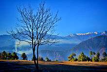
a beautiful setting in shogran, | |
| Country |
|
| Province | Khyber-Pakhtunkhwa |
| District | Mansehra District |
| Time zone | PST (UTC+5) |
Shogran (Urdu: شوگران ) is a hill station situated on a green plateau in the Kaghan Valley, northern Pakistan at a height of 7,749 feet or 2,362 metres above sea level.
Shogran is located at a distance of 34 km away from Balakot. The road from Islamabad to Kiwai is metalled and measures 212 km. From Shogran, you can ride a jeep or horse or hike to several picturesque places like Siri, Paye and Makra Peak.
Hotels and motels are available at affordable costs. Mobile phone services is also available there by Telenor and Mobilink. The local people are friendly and peaceful. It is accessible in the summer. It attracts families and explorers alike.You should not miss a trip to Forest Rest House. Most of people sit and relax in its huge lush green lawns. Entry might be restricted when senior officials visit or stay at rest house. Views of Sri Paya and Musa Da Mussalah peak are really nice from the lawns of rest house.
Weather
Shogran is opened for visitors in summer only, June – August is peak season, during this span weather remains pretty pleasant. Temperature ranges between a maximum of 20°C and a minimum of 3°C at night. Moon soon receives heavy rains with occasional hail storm. Unexpected thunder storm and heavy rains keep environment cool and sometimes create difficulties for visitors to move around. Warm clothes are recommended for nights due to low temperature. Heavy snow keeps valley covered throughout winter season.
See also

- Kaghan valley
- Naran
- Siri Lake
- Payee Lake
- Saiful Muluk Lake
- Lulusar Lake
- Lalazar
- Kiwai
References
External links
- Shogran meadows, Kaghan, Pakistan
- http://www.panoramio.com/user/2000119?comment_page=1&photo_page=4
- https://www.facebook.com/album.php?id=279250773581&aid=335651
Coordinates: 34°38′N 73°28′E / 34.633°N 73.467°E
