Slims River
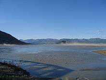
The mouth of the Slims River, at Kluane Lake
The Slims River (A'ay Chu) is a glacially fed river in the Canadian territory of Yukon.[1] It originates in the Kaskawulsh Glacier, then runs approximately 15 mi (24 km) into the southern terminus of Kluane Lake.[2]
The Slims River was purportedly named after a pack horse that drowned while attempting to ford the stream during the 1903 Kluane gold rush.[3] It is crossed by the Alaska Highway at Mile 1065 (Kilometer 1704) just south of its confluence with the lake.
References
- ↑ "Kaskawulsh Glacier - Canadian Glacier Inventory Project". cgip.wikifoundry.com. Retrieved 2016-01-17.
- ↑ "Slims River, Kluane National Park – Map Portfolio – Brodie Elder". bemaps.wordpress.com. Retrieved 2016-01-17.
- ↑ "The Slims River Bridge, Alaska Highway". explorenorth.com. Retrieved 2016-01-17.
Coordinates: 61°00′40″N 138°29′30″W / 61.01111°N 138.49167°W
This article is issued from Wikipedia - version of the 3/30/2016. The text is available under the Creative Commons Attribution/Share Alike but additional terms may apply for the media files.