Sonnenberg
This article is about the German municipality. For other uses, see Sonnenberg (disambiguation).
| Sonnenberg | |
|---|---|
 Sonnenberg | |
Location of Sonnenberg within Oberhavel district 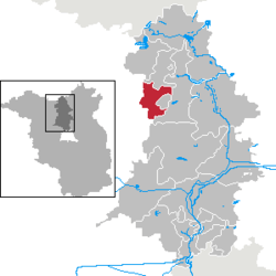 | |
| Coordinates: 53°01′08″N 13°05′19″E / 53.01889°N 13.08861°ECoordinates: 53°01′08″N 13°05′19″E / 53.01889°N 13.08861°E | |
| Country | Germany |
| State | Brandenburg |
| District | Oberhavel |
| Municipal assoc. | Gransee und Gemeinden |
| Government | |
| • Mayor | Ralf Wöller (CDU) |
| Area | |
| • Total | 50.30 km2 (19.42 sq mi) |
| Population (2015-12-31)[1] | |
| • Total | 823 |
| • Density | 16/km2 (42/sq mi) |
| Time zone | CET/CEST (UTC+1/+2) |
| Postal codes | 16775 |
| Dialling codes | 033082 |
| Vehicle registration | OHV |
| Website | Gemeinde Sonnenberg |
Sonnenberg is a municipality in the Oberhavel district, in Brandenburg, Germany.
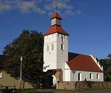
Church of Sonnenberg
Demography
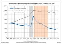
Development of population since 1875 within the current boundaries (Blue line: Population; Dotted line: Comparison to population development of Brandenburg state; Grey background: Time of Nazi rule; Red background: Time of communist rule)
|
|
|
|
References
- ↑ "Bevölkerung im Land Brandenburg nach amtsfreien Gemeinden, Ämtern und Gemeinden 31. Dezember 2015 (Fortgeschriebene amtliche Einwohnerzahlen auf Grundlage des Zensus 2011)". Amt für Statistik Berlin-Brandenburg (in German). 2016.
- ↑ Detailed data sources are to be found in the Wikimedia Commons.Population Projection Brandenburg at Wikimedia Commons
Towns and municipalities in Oberhavel | ||
|---|---|---|
This article is issued from Wikipedia - version of the 6/9/2016. The text is available under the Creative Commons Attribution/Share Alike but additional terms may apply for the media files.