Sonyea Group
| Sonyea Group Stratigraphic range: Frasnian | |
|---|---|
| Type | Group |
| Unit of | Frasnian |
| Sub-units | (See description) |
| Underlies | West Falls Group |
| Overlies | Genesee Group |
| Lithology | |
| Primary | Shale |
| Other | Siltstone |
| Location | |
| Region | Appalachian Basin of eastern North America[1] |
| Country |
|
 Stratigraphic Map of the Sonyea Formation in New York State[2] | |
The Sonyea Group is a geologic group in the northern part of the Appalachian Basin. It preserves fossils dating back to the Devonian period.
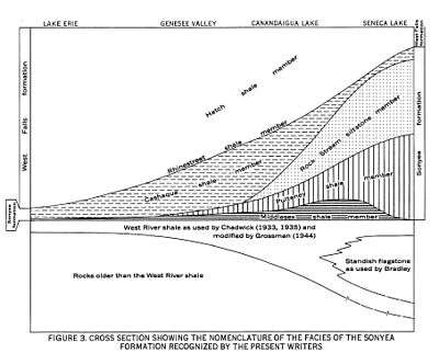
In the western part,[1][3] it is divided into the Cashaqua Shale at the top, and the Middlesex Shale at the bottom. In the east, various shale formations are included between the Cashaqua and Middlesex members, including Rye Point Shale, Rock Stream Formation ("Enfield Formation") Siltstone, Pulteney shale, Sawmill Creek Shale, Johns Creek Shale and Montour Shale.
See also
References
- 1 2 "Sonyea Group". USGS. Retrieved 2015-09-17.
- ↑ Colton, George W.; de Witt, Wallace Jr. (1958). "Stratigraphy of the Sonyea Formation of Late Devonian Age in Western and West-Central New York". United States Geological Survey. United States Department of the Interior. Retrieved 22 September 2015.
- ↑ Rickard, L.V.; Isachsen, Y.W.; Fisher, D.W. (1970). "Geologic map of New York: Finger Lakes sheet". New York State Museum. Retrieved 2015-09-17.
- Various Contributors to the Paleobiology Database. "Fossilworks: Gateway to the Paleobiology Database". Retrieved 22 June 2014.
- Schieber, J. (1999). "Distribution and deposition of mudstone facies in the Upper Devonian Sonyea Group of New York". Journal of Sedimentary Research. SEPM Society for Sedimentary Geology. 69: 909–925. Retrieved 22 September 2015.
This article is issued from Wikipedia - version of the 7/19/2016. The text is available under the Creative Commons Attribution/Share Alike but additional terms may apply for the media files.