Sourdough Mountains

Dege Peak on Sourdough Ridge offers a view Emmons Glacier (left) and Steamboat Prow (center) on the northeast side of Mount Rainier.
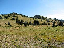
View from the Sunrise lodge area looking northeast. The subalpine meadows of Yakima Park cover the southern slopes of Sourdough Ridge
The Sourdough Mountains, also called Sourdough Ridge,[1] is a mountain ridge on the northeast side of Mount Rainier in Mount Rainier National Park, Washington, United States. The range forms an L-shape, starting at Mount Fremont, running east to Dege Peak, turning north to Slide Mountain.
The ridge is a popular hiking destination, due to the excellent view of Mount Rainier and its proximity to roads and the Sunrise Visitor Center.
References
- ↑ Beckey, Fred (2000). Cascade Alpine Guide: Climbing and High Routes: Columbia River to Stevens Pass (3rd ed.). The Mountaineers. p. 136. ISBN 978-0-89886-577-6.
External links
 Media related to Sourdough Mountains at Wikimedia Commons
- U.S. Geological Survey Geographic Names Information System: Sourdough Mountains
- U.S. Geological Survey Geographic Names Information System: Yakima Park
- U.S. Geological Survey Geographic Names Information System: Sunrise Visitor Center
- U.S. Geological Survey Geographic Names Information System: Sunrise Lodge
Coordinates: 46°55′17″N 121°36′47″W / 46.92139°N 121.61306°W
This article is issued from Wikipedia - version of the 7/28/2016. The text is available under the Creative Commons Attribution/Share Alike but additional terms may apply for the media files.