Saint Ouen, Jersey
| Saint Ouën | ||
|---|---|---|
| Jersey parish | ||
|
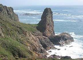
Cliffs at Plémont | ||
| ||
 Location of Saint Ouën in Jersey | ||
| Crown Dependency | Jersey, Channel Islands | |
| Government[1] | ||
| • Connétable | Michael Paddock | |
| Area | ||
| • Total | 15 km2 (6 sq mi) | |
| Area rank | Ranked 1st | |
| Population (2011)[2] | ||
| • Total | 4,097 | |
| • Density | 270/km2 (710/sq mi) | |
| Time zone | GMT | |
| • Summer (DST) | UTC+01 (UTC) | |
| Postcode district | JE3 | |
| Postcode sector | 2 | |
Saint Ouen (Jèrriais: Saint Ouën) is one of the twelve parishes of Jersey in the Channel Islands. It is in the north west of Jersey. The parish is the largest parish by surface area, covering 8,341 vergées (15 km²).
It is reputed to be the most traditional of the parishes, being the farthest from Saint Helier and with much of the territory of the parish forming a peninsula. Its manor, Saint Ouen's Manor, the seat of the de Carteret family for over eight centuries - is the senior fief in the island, and the influence of that family has also been a factor in the parish's independent-minded approach to its affairs.
Culture


A number of the most influential writers of Jersey have been St. Ouennais. George F. Le Feuvre (1891–1984), who wrote under the pseudonym "George d'la Forge", was one of the most prolific authors of Jèrriais literature of the 20th century. Frank Le Maistre (1910–2002), compiler of the Dictionnaire Jersiais-Français (1966), did much to standardise the St. Ouennais dialect of Jèrriais as a literary language. Edward Le Brocq (1877–1964) wrote a weekly newspaper column from 1946 to 1964 recounting the lives and opinions of two St. Ouennais characters, Ph'lip and Merrienne.
The traditional nickname for St. Ouennais is Gris Ventres (grey bellies) - a reference to the custom of men from the parish to wear jerseys of undyed wool, which distinguished them from men from other parishes who generally wore blue.
A number of prehistoric sites are located in St. Ouen, including the dolmen des Monts Grantez, located at Le Chemin des Monts;[3] the dolmen des Geonnais;[4] and the prehistoric site at Le Pinacle,[5] which also contains one of the very few identifiable Gallo-Roman sites to be seen in Jersey, the foundations of a fanum (small temple).
Sark was recolonised by St. Ouennais. Helier de Carteret, the seigneur of the parish, received a charter from Queen Elizabeth I to colonise Sark with 40 families from the parish on condition that he maintain the island free of pirates. Sercquiais is therefore a very old offshoot of St Ouennais Jèrriais. The St. Ouennais origins of Sercquiais can be seen in the 2nd and 3rd person plural forms of the preterite. Sercquiais uses an ending -dr which is typical of the St. Ouennais dialect of Jèrriais, but generally not used elsewhere in Jersey (nor nowadays by younger speakers in St. Ouen).
| Sercquiais | Jèrriais (St. Ouennais) |
standard Jèrriais | English |
|---|---|---|---|
| i vuliidr | i' voulîdrent | i' voulîtent | they wanted |
| uu paaliidr | ou pâlîdres | ou pâlîtes | you spoke |
| i füüdr | i' fûdrent | i' fûtent | they were |
| uu prẽẽdr | ou prîndres | ou prîntes | you took |
In the north west, the ruins of Grosnez Castle are a landmark which also features on the Jersey 50 pence coin (see coins of the Jersey pound).
The Island's racecourse is also to be found at Les Landes.
Demographics
| Historical population | ||
|---|---|---|
| Year | Pop. | ±% |
| 1991 | 3,612 | — |
| 1996 | 3,685 | +2.0% |
| 2001 | 3,803 | +3.2% |
| 2011 | 4,097 | +7.7% |
Cueillettes
Unlike the other parishes of Jersey, the subdivisions of this parish are not named vingtaines, but cueillettes (Jèrriais: tchilliettes). Vingteniers are still elected, however, in the cueillettes.
- La Petite Cueillette
- La Grande Cueillette
- La Cueillette de Grantez
- La Cueillette de Millais
- La Cueillette de Vinchelez
- La Cueillette de Léoville
St. Ouen forms one electoral district and elects one Deputy.
Education
Les Landes School is a primary school, run by the States of Jersey, and located on La Rue des Cosnets, in Saint Ouen.[6]
Sport
Saint Ouen's local football team is St. Ouen F.C.[7]
Gallery
 Road sign in La Néthe Rue (the black road in Jèrriais)
 German Occupation observation tower situated at Les Landes
 A field entrance in St. Ouen
 Saint Ouen bilingual sign
- Le Don Hacquoil
References
- ↑ "Members". Statesassembly.gov.je. Retrieved 2012-10-13.
- ↑ "Archived copy" (PDF). Archived from the original (PDF) on March 1, 2014. Retrieved October 3, 2012.
- ↑ Jeremy Percival. "Les Mont de Grantez". Prehistoricjersey.net. Retrieved 2012-10-03.
- ↑ Jeremy Percival. "Dolmen des Geonnais". Prehistoricjersey.net. Retrieved 2012-10-03.
- ↑ Jeremy Percival. "Le Pinacle". Prehistoricjersey.net. Retrieved 2012-10-03.
- ↑ "Primary schools". Gov.je. 2012-08-30. Retrieved 2012-10-03.
- ↑ "Jersey - Sport - St. Ouen". BBC. 2014-11-27. Retrieved 2016-04-11.
External links
| Wikimedia Commons has media related to Saint Ouen, Jersey. |
Coordinates: 49°14′25″N 2°13′13″W / 49.24024°N 2.22027°W

.svg.png)