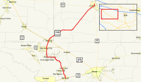
Texas State Highway 198
| ||||
|---|---|---|---|---|
 | ||||
| Route information | ||||
| Maintained by TxDOT | ||||
| Length: | 37.673 mi[1] (60.629 km) | |||
| Existed: | by 1935 – present | |||
| Major junctions | ||||
| South end: |
| |||
|
| ||||
| North end: |
| |||
| Highway system | ||||
| ||||
State Highway 198 or SH 198 is a Texas state highway that runs between Malakoff and Canton. The route was originally designated by 1935 from Canton to Mabank. In 1983, it was extended south to Malakoff, replacing part of FM 90.
Major intersections
| County | Location | mi | km | Destinations | Notes |
|---|---|---|---|---|---|
| Henderson | Malakoff | Southern terminus | |||
| Caney City | |||||
| Log Cabin | |||||
| Payne Springs | |||||
| Gun Barrel City | |||||
| Kaufman | Mabank | ||||
| Van Zandt | | ||||
| | |||||
| | |||||
| | |||||
| | |||||
| Canton | |||||
| Northern terminus | |||||
| 1.000 mi = 1.609 km; 1.000 km = 0.621 mi | |||||
References
- ↑ Transportation Planning and Programming Division (n.d.). "State Highway No. 198". Highway Designation Files. Texas Department of Transportation. Retrieved January 31, 2016.
This article is issued from Wikipedia - version of the 7/31/2016. The text is available under the Creative Commons Attribution/Share Alike but additional terms may apply for the media files.
