Texas State Highway 81
| ||||
|---|---|---|---|---|
 | ||||
| Route information | ||||
| Maintained by TxDOT | ||||
| Length: | 23.354 mi[1] (37.585 km) | |||
| Existed: | 1991 – present | |||
| Major junctions | ||||
| South end: |
| |||
| North end: |
| |||
| Location | ||||
| Counties: | Hill, Johnson | |||
| Highway system | ||||
| ||||
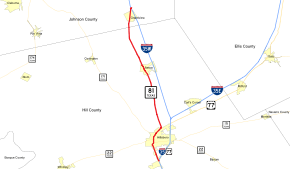
State Highway 81 (SH 81) is a Texas state highway that runs from Hillsboro to Grandview. It was designated in 1991 to replace U.S. Highway 81, which was decommissioned south of Fort Worth.[1]
Route description
SH 81 begins along the ramp from northbound I-35's exit #364B; the route is accessible from the southbound freeway at exit #364A for FM 310.[2] It travels north into Hillsboro along Abbott Avenue.[3] SH 81 has a half-mile concurrency with SH 22 / SH 171 through the city's downtown before continuing northward along Waco Street. At the northern edge of Hillsboro, the highway has an interchange with Spur 579, which provides access to Interstate 35, as well as US 77, just south of the point at which the freeway splits into I-35W and I-35E.[2]
North of Hillsboro, SH 81 roughly parallels I-35W, which lies to the east.[4] While the freeway bypasses the cities of Itasca and Grandview, SH 81 enters them directly, along Hill Street and 3rd Street, respectively. In Grandview, it intersects FM 916 and also FM 4 at that route's southern terminus before continuing northward to its end at I-35W's exit #16; the roadway continues as County Road 201A.[4]
History
Current route
As a majority of US 81 south of Fort Worth had already been superseded by the Interstate 35 freeway south of Fort Worth, the entire segment of that route from Fort Worth to Laredo was eliminated in 1991.[5] Many of the former pre-freeway alignments that were kept as part of the state highway system were replaced by various routes, including state highway loops and business routes of Interstate 35. SH 81 was designated to replace the segment in Hill and Johnson counties, and represents the longest section south of Fort Worth with which US 81 did not have a concurrency with Interstate 35.[1]
Pre-1939 route
The first highway designated SH 81 was originally proposed as a route through central Texas, beginning in Bandera and traveling south then turning southeast through San Antonio, with a final ending point at Cuero. By 1928, SH 81 had extended to Kerrville. By 1933, SH 81 had been extended north to De Leon, replacing SH 124 and a portion of SH 20. By 1936, the section east of San Antonio was transferred to SH 27. By 1938, the section from San Antonio to Kerrville was replaced by SH 16. By 1939, the entire route north of Kerrville had also been transferred to SH 16.
Major intersections
| County | Location | mi[6] | km | Destinations | Notes |
|---|---|---|---|---|---|
| Hill | Hillsboro | 0.0 | 0.0 | Southern terminus; northbound exit and southbound entrance | |
| 2.8 | 4.5 | South end of SH 22/171 concurrency | |||
| 3.3 | 5.3 | North end of SH 22/171 concurrency | |||
| 5.1 | 8.2 | ||||
| Lovelace | 9.1 | 14.6 | |||
| | 11.2 | 18.0 | |||
| Itasca | 13.3 | 21.4 | |||
| 14.2 | 22.9 | ||||
| | 16.9 | 27.2 | |||
| | 18.4 | 29.6 | |||
| Johnson | Grandview | 22.2 | 35.7 | ||
| | 23.4 | 37.7 | Northern terminus; roadway continues as CR 201A | ||
| 1.000 mi = 1.609 km; 1.000 km = 0.621 mi | |||||
References
- 1 2 3 Transportation Planning and Programming Division (n.d.). "State Highway No. 81". Highway Designation Files. Texas Department of Transportation. Retrieved 2011-09-30.
- 1 2 Transportation Planning and Programming Division (2012). Texas County Map Book (PDF) (Map) (2012 ed.). 1:120,000. Texas Department of Transportation. p. 485. OCLC 867856197. Retrieved 2011-10-03.
- ↑ Transportation Planning and Programming Division (2012). Texas County Map Book (PDF) (Map) (2012 ed.). 1:120,000. Texas Department of Transportation. p. 455. OCLC 867856197. Retrieved 2011-10-03.
- 1 2 Transportation Planning and Programming Division (2012). Texas County Map Book (PDF) (Map) (2012 ed.). 1:120,000. Texas Department of Transportation. p. 484. OCLC 867856197. Retrieved 2011-10-03.
- ↑ Transportation Planning and Programming Division (n.d.). "U.S. Highway No. 81". Highway Designation Files. Texas Department of Transportation. Retrieved 2011-10-03.
- ↑ Google (2011-10-03). "Overview map of Texas State Highway 81 Distances Between Interchanges" (Map). Google Maps. Google. Retrieved 2011-10-03.
