Swainby
| Swainby | |
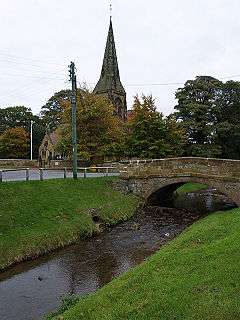
 Scugdale Beck at Swainby with Holy Cross Church in the background |
|
 Swainby |
|
| OS grid reference | NZ477019 |
|---|---|
| – London | 215 mi (346 km) south |
| Civil parish | Whorlton |
| District | Hambleton |
| Shire county | North Yorkshire |
| Region | Yorkshire and the Humber |
| Country | England |
| Sovereign state | United Kingdom |
| Post town | NORTHALLERTON |
| Postcode district | DL6 |
| Dialling code | 01642 |
| Police | North Yorkshire |
| Fire | North Yorkshire |
| Ambulance | Yorkshire |
| EU Parliament | Yorkshire and the Humber |
| UK Parliament | Richmond |
Coordinates: 54°24′41″N 1°15′57″W / 54.4114°N 1.2658°W
Swainby is a village in the Hambleton district of North Yorkshire, England. It is situated on the A172 road, 8 miles (13 km) north-east from Northallerton and 5 miles (8.0 km) south-east from the small market town of Stokesley.
Overview
Swainby is located at the north-western corner of the North York Moors National Park. The characteristics of the village and the surrounding area consist of traditional Yorkshire dry stone walls, hills, sheep, heather and moorland.
The village is close to the ruins of Whorlton Castle; Swainby appears to have been built after its abandonment.
In the 19th century the housing of miners who worked the nearby hills for ironstone and jet led to an expansion of the village.
Swainby contains two public houses, "The Blacksmiths Arms" and "The Black Horse", and a caravan park with farm house.
Governance
Although Swainby is in Whorlton civil ward it has retained an electoral ward in its own name. The population of this ward taken at the 2011 census was 1,820.[1]
See also
References
- ↑ "Ward population 2011". Retrieved 1 August 2015.
External links
![]() Media related to Swainby at Wikimedia Commons
Media related to Swainby at Wikimedia Commons