Tait Tower

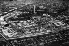
Tait Tower (also known as Tait's Tower and officially as the Tower of Empire) was a tower in the art deco style constructed at the summit of Ibrox Hill in Bellahouston Park in Glasgow in Scotland as part of the Empire Exhibition, Scotland 1938.
It was designed by Thomas S. Tait, stood 300 feet (91 metres) high and had three separate observation decks which provided a view of the surrounding gardens and city. Due to both the height of the tower and the hill it was built on, it could be seen 100 miles (160 km) away. The tower was the centrepiece of the Empire Exhibition and its image featured on many of the souvenirs that could be bought at the exhibition site.
The Empire Exhibition took place at a time when Glasgow was the centre of British shipbuilding and engineering, and the materials - steel beams riveted together and clad in corrugated steel - were produced by Glasgow manufacturing plants. Tait's design and readily available materials made it possible for the tower to be constructed in only nine weeks.[1]
Although it was to have been a permanent monument to the exhibition, orders were given to demolish the tower in July 1939,[2] The foundations remain.
Thomas' son Gordon Tait also worked on the project.
In December 2007, the Tait Tower was included in a 3D graphic reconstruction of the Empire Exhibition by the Digital Design Studio at Glasgow School of Art, sourced from contemporary photographs, film footage, sketches and drawings from the archive of the Mitchell Library.[3][4]
References
- ↑ Glancey, Jonathan (1998). C20th Architecture: The Structures that Shaped the Century. Carlton Books. ISBN 0-87951-912-6.
- ↑ Glasgow's Great Exhibitions, P & J Kinchin, White Cockade Publishing.
- ↑ Greenshields, Karen. "Empire Exhibition Strikes Back". STV News. Scottish Television. Retrieved 2008-11-16.
- ↑ McKinnon, Ross (2007-05-23). "THE EMPIRE STRIKES BACK: Second city of Exhibition is reborn for 21st century". Evening Times (Glasgow). Retrieved 2008-11-16.
External links
- Information about the tower and picture
- Information about the 1938 exhibition and the tower
- Tower of Empire - 3D reconstruction of the tower by Glasgow School of Art
- Photographs of the Tait Tower - Mitchell Library
Coordinates: 55°50′44″N 4°19′02″W / 55.84547°N 4.31729°W