Tarkastad
| Tarkastad | |
|---|---|
|
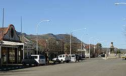
The main street in Tarkastad, 2012 | |
 Tarkastad  Tarkastad  Tarkastad
| |
| Coordinates: 32°01′S 26°16′E / 32.017°S 26.267°ECoordinates: 32°01′S 26°16′E / 32.017°S 26.267°E | |
| Country | South Africa |
| Province | Eastern Cape |
| District | Chris Hani |
| Municipality | Tsolwana |
| Established | 1862 |
| Area[1] | |
| • Total | 83.5 km2 (32.2 sq mi) |
| Population (2011)[1] | |
| • Total | 6,059 |
| • Density | 73/km2 (190/sq mi) |
| Racial makeup (2011)[1] | |
| • Black African | 84.7% |
| • Coloured | 10.5% |
| • Indian/Asian | 0.1% |
| • White | 3.9% |
| • Other | 0.8% |
| First languages (2011)[1] | |
| • Xhosa | 80.5% |
| • Afrikaans | 14.0% |
| • English | 3.3% |
| • Other | 2.2% |
| Postal code (street) | 5370 |
| PO box | 5370 |
| Area code | 045 |
Tarkastad is a small Karoo town in the Eastern Cape province of South Africa. Tarkastad is on a plain to the north of the Winterberg mountain range. The name Tarkastad is believed to come from the Khoi-Khoi word Traka (meaning women) or the Celtic word Tarka (meaning otter) and the Afrikaans word Stad (meaning city).
History
Tarkastad was established in 1862 as a church centre and became a municipality in 1864. Elands River Poort, a mountain pass located in the Karoo, 24 km to the NNW of Tarkastad,[2] where the Battle of Elands River (1901) was fought during the Second Boer War.[3] The grave of Lt. Sheridan, cousin of Winston Churchill, who was killed in the Battle of Elands River can be found on the Modderfontein farm just outside Tarkastad.
San rock paintings can be seen in the area. Victorian cast iron lamp posts and broekie lace adornments indicate the British colonial influence. Tarkastad's first Municipal Manager after apartheid was Mr Smilo Dayi an ex-political prisoner. The first mayor after apartheid was Mr Ntsikelelo Sampempe.
References
- 1 2 3 4 Sum of the Main Places Tarkastad and Zola from Census 2011.
- ↑ Elands River Poort, South Africa
- ↑ Eastern Cape and the Anglo-Boer War

.svg.png)