Tennessee State Route 133
| ||||
|---|---|---|---|---|
| Route information | ||||
| Maintained by TDOT | ||||
| Length: | 11.24 mi (18.09 km) | |||
| Major junctions | ||||
| South end: |
| |||
| North end: |
| |||
| Location | ||||
| Counties: | Johnson | |||
| Highway system | ||||
| ||||

State Route 133 (SR 133) is a state route in northeastern Tennessee in Johnson County. It begins at Shady Valley, Tennessee and runs northward for about 11 miles (18 km) to the Tennessee–Virginia state border.
Route description
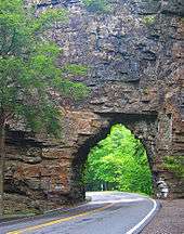
State Route 133 passing through the Backbone Rock Tunnel
SR-133 begins in Shady Valley, where it intersects with U.S. Route 421 (US 421), SR-34, and SR-91. The road progresses northward from Shady Valley through the communities of Crandull and Sutherland, passing through the Cherokee National Forest, to its terminus at the state border with Virginia.[1] South of Sutherland, the highway passes through the Backbone Rock Tunnel, an old railroad tunnel used by the Beaver Dam Railroad known as "the shortest tunnel in the world."[2][3]
Major intersections
The entire route is in Johnson County.
| Location | mi | km | Destinations | Notes | |
|---|---|---|---|---|---|
| Shady Valley | |||||
| | Virginia state line | ||||
| 1.000 mi = 1.609 km; 1.000 km = 0.621 mi | |||||
References
- ↑ General Highway Map: Johnson County, Tennessee (PDF) (Map). Cartography by TDOT Planning Division. Tennessee Department of Transportation. 2003. Retrieved December 10, 2012.
- ↑ McGuinn, Doug (2008). Green Gold: The Story of the Hassinger Lumber Company of Konnarock, Virginia. Lulu.com. p. 57. ISBN 9781427629760.
- ↑ United States Forest Service. "Backbone Rock Recreation Area". U.S. Department of Agriculture. Retrieved February 5, 2013.
This article is issued from Wikipedia - version of the 10/26/2016. The text is available under the Creative Commons Attribution/Share Alike but additional terms may apply for the media files.