Texas State Highway 132
| ||||
|---|---|---|---|---|
 | ||||
| Route information | ||||
| Maintained by TxDOT | ||||
| Length: | 12.77 mi[1] (20.55 km) | |||
| Existed: | 1991 – present | |||
| Major junctions | ||||
| Southwest end: |
| |||
| Northeast end: |
| |||
| Highway system | ||||
| ||||

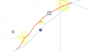
State Highway 132 or SH 132 is a state highway in Texas, United States, running between Devine and Lytle. The highway was designated in 1991 to replace U.S. Route 81, which was decommissioned.[2]
History
SH 132 was originally proposed by 1928[3] as a route from Livingston to Liberty replacing a portion of SH 35A. By 1933, this route became a portion of SH 146.
Junction list
| County | Location | mi | km | Destinations | Notes |
|---|---|---|---|---|---|
| Medina | | ||||
| Devine | |||||
| Natalia | South end of FM 471 overlap | ||||
| North end of FM 471 overlap | |||||
| Atascosa | Lytle | South end of FM 2790 overlap | |||
| North end of FM 2790 overlap | |||||
| Bexar | |||||
1.000 mi = 1.609 km; 1.000 km = 0.621 mi
| |||||
References
- ↑ Transportation Planning and Programming Division (n.d.). "State Highway No. 132". Highway Designation Files. Texas Department of Transportation. Retrieved 2010-06-15.
- ↑ Transportation Planning and Programming Division (n.d.). "U.S. Highway No. 81". Highway Designation Files. Texas Department of Transportation. Retrieved August 4, 2016.
- ↑ Official Map of the Highway System of Texas (Map) (1928/1929 ed.). Texas State Highway Department. Retrieved 2011-08-18.
This article is issued from Wikipedia - version of the 8/4/2016. The text is available under the Creative Commons Attribution/Share Alike but additional terms may apply for the media files.