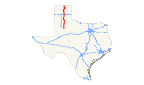
Texas State Highway 207
| ||||
|---|---|---|---|---|
 | ||||
| Route information | ||||
| Maintained by TxDOT | ||||
| Length: | 199.712 mi[1] (321.405 km) | |||
| Existed: | by 1935 – present | |||
| Major junctions | ||||
| South end: |
| |||
|
| ||||
| North end: | CR 202 at Oklahoma state line southeast of Guymon | |||
| Highway system | ||||
| ||||

State Highway 207 or SH 207 is a state Highway that runs from Post, Texas through the South Plains and Texas Panhandle to the Texas/Oklahoma state line.
History
The highway was originally designated between 1933 and 1935 between Floydada and Ralls. By 1939, the designation was extended north to Silverton and south to Garden City. By 1947, most of the route had been cancelled or transferred to US 62, leaving only the section between Silverton and Floydada. In 1967, the route was extended north along its current route, displacing FM 122, FM 284, SH 282, and a portion of the rerouted SH 15.[2][3][4][5]
Junction list
| County | Location | mi | km | Destinations | Notes |
|---|---|---|---|---|---|
| Garza | Post | ||||
| | |||||
| Crosby | | South end of FM 40 overlap | |||
| | North end of FM 40 overlap | ||||
| Ralls | |||||
| South end of US 62 overlap | |||||
| | |||||
| | |||||
| Floyd | | ||||
| | |||||
| Floydada | South end of US 70 overlap | ||||
| North end of US 62 / US 70 overlap | |||||
| | South end of FM 786 overlap | ||||
| | North end of FM 786 overlap | ||||
| | South end of FM 97 overlap | ||||
| | North end of FM 97 overlap | ||||
| | |||||
| | |||||
| Briscoe | | ||||
| Silverton | South end of SH 86 overlap | ||||
| | |||||
| | North end of SH 86 overlap | ||||
| | |||||
| | |||||
| Armstrong | | ||||
| | |||||
| | |||||
| Claude | |||||
| Carson | | Former Route 66 | |||
| | I-40 exit 96 | ||||
| Panhandle | |||||
| | |||||
| Hutchinson | Borger | ||||
| South end of SH 136 overlap | |||||
| South end of SH 152 overlap | |||||
| | |||||
| | |||||
| Stinnett | North end of SH 152 overlap | ||||
| | North end of SH 136 overlap | ||||
| | |||||
| Hansford | | ||||
| | |||||
| Spearman | South end of SH 15 overlap | ||||
| | |||||
| | |||||
| | |||||
| | North end of SH 15 overlap | ||||
| | |||||
| | |||||
| | |||||
| | Oklahoma CR 202 | Texas/Oklahoma state line | |||
1.000 mi = 1.609 km; 1.000 km = 0.621 mi
| |||||
Gallery
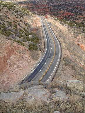 Highway 207 as it winds its way through the valley of the Prairie Dog Town Fork Red River, Armstrong County. This section of Highway 207 is also known as Hamblen Drive, named after Will H. Hamblen (1876–1952), a local rancher.
See also
References
| Wikimedia Commons has media related to Texas State Highway 207. |
- ↑ Transportation Planning and Programming Division (n.d.). "State Highway No. 207". Highway Designation Files. Texas Department of Transportation. Retrieved 2008-04-03.
- ↑ Transportation Planning and Programming Division (n.d.). "Farm to Market Road No. 122". Highway Designation Files. Texas Department of Transportation. Retrieved September 30, 2016.
- ↑ Transportation Planning and Programming Division (n.d.). "Farm to Market Road No. 284". Highway Designation Files. Texas Department of Transportation. Retrieved September 30, 2016.
- ↑ Transportation Planning and Programming Division (n.d.). "State Highway No. 282". Highway Designation Files. Texas Department of Transportation. Retrieved September 30, 2016.
- ↑ Transportation Planning and Programming Division (n.d.). "State Highway No. 15". Highway Designation Files. Texas Department of Transportation. Retrieved September 30, 2016.
External links
This article is issued from Wikipedia - version of the 10/1/2016. The text is available under the Creative Commons Attribution/Share Alike but additional terms may apply for the media files.