Texas State Highway 286
| ||||
|---|---|---|---|---|
 | ||||
| Route information | ||||
| Maintained by TxDOT | ||||
| Length: | 15.209 mi[1] (24.477 km) | |||
| Existed: | 1939 – present | |||
| Major junctions | ||||
| South end: |
| |||
|
| ||||
| North end: |
| |||
| Highway system | ||||
| ||||

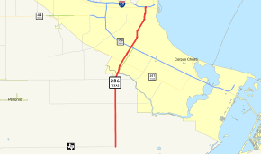
State Highway 286 or SH 286 is a Texas state highway running from downtown Corpus Christi south to Chapman Ranch. The route was designated on its current route in 1939. Before 1939, this route was known as SH 96, and was proposed to be extended to the southwest to Riviera. It is also locally known as the "Crosstown Expressway"
History
The route from Corpus Christi to Chapman Ranch was originally designated as a portion of SH 96 as early as 1933.[2] The highway was redesignated to SH 286 in 1939.[1]
Route description
The route of SH 286 runs from FM 70 northward to I-37 in Corpus Christi in Nueces County.[1] The southern terminus is located in rural Nueces County at FM 70 south of Corpus Christi. The highway heads north with intersections at FM 2444 and FM 43 before turning to the northeast and crossing Oso Creek near Cabaniss Field Naval Air Station. SH 286 becomes a freeway south of SH 357 (Saratoga Boulevard). The freeway portion of the highway is known as the Crosstown Expressway. As the freeway heads to the northeast, it has an interchange with SH 358 (South Padre Island Drive). The freeway continues to the northeast from the interchange through downtown Corpus Christi. The freeway ends at I-37 to the west of Corpus Christi Bay.[3]
Junction list
The entire route is in Nueces County. All exits are unnumbered.
| Location | mi | km | Destinations | Notes | |
|---|---|---|---|---|---|
| Chapman Ranch | |||||
| | |||||
| | |||||
| Corpus Christi | South end of freeway | ||||
| Holly Road | |||||
| Gollihar Road | |||||
| Horne Road | |||||
| Tarlton Street / Port Avenue | |||||
| Baldwin Boulevard | |||||
| Access to Spohn Memorial Hospital | |||||
| Laredo Street / Agnes Street | |||||
| Lipan Street / Comanche Street | Northbound exit, southbound entrance | ||||
| Northbound exit, southbound entrance | |||||
| 1.000 mi = 1.609 km; 1.000 km = 0.621 mi | |||||
References
- 1 2 3 Transportation Planning and Programming Division (n.d.). "State Highway No. 286". Highway Designation Files. Texas Department of Transportation. Retrieved 2008-03-11.
- ↑ Official Map of the Highway System of Texas (Map). Texas State Highway Department. 1933. Retrieved 2008-03-11.
- ↑ Google (2008-03-11). "overview map of SH 286" (Map). Google Maps. Google. Retrieved 2008-03-11.