Texas State Highway Loop 20
| ||||
|---|---|---|---|---|
|
Bob Bullock Loop Cuatro Vientos Road | ||||
 | ||||
| Route information | ||||
| Length: | 24 mi (39 km) | |||
| Existed: | 1939 – present | |||
| Major junctions | ||||
| CW end: | MX 85D at Mexican border on World Trade International Bridge | |||
|
| ||||
| CCW end: | Mangana-Hein Road | |||
| Highway system | ||||
| ||||

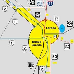
Loop 20,[1] also known as the Bob Bullock Loop and Cuatro Vientos Road, is a highway loop that runs to the north and east of the city of Laredo, Texas. Loop 20 extends from the World Trade International Bridge at its northern point to Mangana-Hein Road at its southern point. The current route varies in construction from a 2-lane road (at its southernmost end) to a freeway with frontage roads (near the World Trade Bridge).
In recent years, much of Laredo's growth has been along Loop 20, with the construction of a new passenger terminal at Laredo International Airport, the Laredo Energy Arena, the new campus of Texas A&M International University, and Doctors Hospital being the most prominent projects.
Cuatro Vientos Road
In 2011, Loop 20 was extended an additional 7 miles (11 km) from Texas State Highway 359 south to Mangana-Hein Road along a new-location route, bypassing the southern portion of the city of Laredo to the east. The former section of Loop 20 between U.S. Route 83 and Highway 359 was redesignated as Texas State Highway Spur 260.
Future expansion
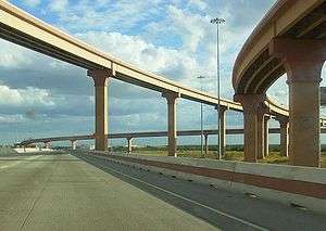
The Texas Department of Transportation's Laredo District is preparing for future growth with plans to upgrade Loop 20 into a freeway by building overpasses at major intersections and constructing frontage roads.[2] A short freeway section, which is co-signed with both Interstate 69W and U.S. Highway 59, currently exists from the World Trade International Bridge east to Interstate 35 and TxDOT recently constructed a diamond interchange at Loop 20's intersection with U.S. Highway 59 in eastern Laredo;[3] the stack interchange with Interstate 35, locally known as the Milo Interchange, is partially complete. As of 2008, TxDOT planned to complete interchanges and overpasses at all of Loop 20's major intersections within the next ten years.[4]
As of 2011, TxDOT is currently constructing an interchange at State Highway 359. An additional interchange at Clark Boulevard, Texas State Highway Spur 400, has been announced by the City of Laredo.[5]
The Cuatro Vientos Road portion of the route is designed for future expansion to a freeway throughout, as well as an extension to the south to U.S. 83 in the vicinity of Rio Bravo, possibly connecting to a future international bridge.
Previous routes
The northwest section of Loop 20 west of I-35 to Farm to Market Road 1472 was originally part of FM 3464,[6][7] a 1.15-mile (1.9 km) road built in 1983 to connect I-35 to FM 1472 in northern Laredo, Texas. In 1988, the route was extended east 2.0 miles (3.2 km) over FM 3488, which was cancelled. In 2000, FM 3464 was redesignated as part of Loop 20.
Junction list
The entire route is in Webb County.
| Location | mi | km | Destinations | Notes | |
|---|---|---|---|---|---|
| Rio Grande | World Trade International Bridge | ||||
| Laredo | U.S. Customs | ||||
| Diamond interchange with flyover from FM 1472 southbound to Loop 20 eastbound | |||||
| Current east end of freeway & current north end of I-69W overlap, 3 of 8 direct connectors open to traffic | |||||
| McPherson Road | |||||
| International Boulevard | |||||
| Shiloh Drive | |||||
| Del Mar Boulevard | |||||
| University Boulevard | |||||
| Jacaman Road | |||||
| Diamond interchange, east end of US 59 overlap; Future north end of I-69W overlap, access to Laredo Medical Center | |||||
| Interchange under construction | |||||
| Jalapa Street | Southbound entrance/exit only | ||||
| Wormser Road | Temporary at-grade crossing | ||||
| La Pita Mangana Road | Southbound entrance/exit only | ||||
| Sierra Vista Boulevard | |||||
| Mangana-Hein Road | Temporary southern terminus | ||||
| 1.000 mi = 1.609 km; 1.000 km = 0.621 mi | |||||
References
- ↑ Transportation Planning and Programming Division (n.d.). "State Highway Loop No. 20". Highway Designation Files. Texas Department of Transportation.
- ↑ TxDOT Laredo District Loop 20 Mobility Project
- ↑ News Release: Loop 20-US 59 traffic switches - Loop 20 traffic over bridge
- ↑ Ashley Richards, "Corridor options narrow," Laredo Morning Times, June 12, 2008.
- ↑
- ↑ Transportation Planning and Programming Division (n.d.). "Farm to Market Road No. 3464". Highway Designation Files. Texas Department of Transportation.
- ↑ Transportation Planning and Programming Division (n.d.). "Urban Road No. 3464". Highway Designation Files. Texas Department of Transportation.
