Thevenard Island


Thevenard Island is located approximately 22 kilometres (14 mi) off the coast from Onslow in the Pilbara region of Western Australia.[1][2]
Description
The island is the largest of a group of ten islands called the Mackerel Islands.[3] Only two islands in the group, Thevenard and Direction Islands, have accommodation for tourists.[4] The Mackerel Islands airstrip, complete with a 1,000-metre (3,281 ft) paved runway, is found on Thevenard.[5]
The island is approximately 6 kilometres (4 mi) in length[3] and occupies a total area of 550 hectares (1,359 acres).[6] It is surrounded by limestone reefs and platforms, with diverse coral assemblages on the northern side.[7] Areas of deep sandy soil are found on the island supporting Acacia and Triodia shrubland and coastal heath scrub.[8]
Fauna
Classified as a C class nature reserve, the island is visited by green turtles and flatback sea turtles who lay their eggs on the beaches. The waters off-shore are also home to dugong and several species of dolphins including; common, bottlenose, spinner and humpback dolphins.[9] The endangered Thevenard Island short-tailed mouse is endemic to the island, with an estimated 2,000 individuals remaining. The mouse population is in decline as a result of loss of habitat and competition from the house mouse, which was introduced to the island in 1985.[8]
History
The island was visited by indigenous Australians before and after its separation from the mainland, approximately 8,000 years ago.[10]
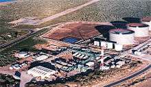
WAPET discovered the Saladin oil field, the North West Shelf just off the island in 1985. The company was granted a 25 hectares (62 acres) lease to build production facilities on the island;[6] the first oil was produced from the project in 1989.[11] Other fields were brought online between 1991 and 1998 using facilities both off-shore and on Thevernard itself.[6]
The MV Boa Force was shipwrecked off the island when the anchor handling tug supply vessel struck a wellhead in 1994. All eleven crew were rescued; Boa Force was later raised and subsequently scuttled in deep water.[12]
Production from off-shore oil fields including Saladin ceased in 2014. The new owners, Chevron Corporation, tried to sell the facilities on Thevernard without success. The decision was made in 2015 to decommission the site, with the removal of all plant, road and footing expected to take two years.[6]
See also
References
- ↑ Gazetteer of Australia (1996). Belconnen, ACT: Australian Surveying and Land Information Group.
- ↑ "Place names of Australia". Geoscience Australia. 2004.
- 1 2 "Onslow" (PDF). Landcorp. Retrieved 23 December 2015.
- ↑ "Mackerel Islands, Western Australia". Mackerel Islands. 2014. Retrieved 23 December 2015.
- ↑ "Thevenard Island Aerodrome Fact Sheet" (PDF). Mackerel Islands Pty Ltd. Retrieved 23 December 2015.
- 1 2 3 4 Rick Wilkinson (16 April 2015). "Chevron group plans decommissioning of Thevenard Island facilities". Oil and Gas Journal. PennWell Corporation. Retrieved 23 December 2015.
- ↑ Peter Collins (26 March 2010). "Macedon Gas Development Subtidal Marine Ecology Survey" (PDF). URS Australia.
- 1 2 "The Action Plan for Australian Rodents". Department of the Environment. 1 April 1995. Retrieved 24 December 2015.
- ↑ "Thevenard Island Mackeral Islands Western Australia". Discover Australia Holidays. 2015. Retrieved 23 December 2015.
- ↑ Dortch, C; Morse (1984). "Prehistoric stone artefacts on some offshore islands in Western Australia". Australian Archaeology: 31–47.
- ↑ "History - People, Partnerships and Performance Since the Early 1950s". Chevron Corporation. 2015. Retrieved 23 December 2015.
- ↑ "Navigation Act 1912. Navigation (Marine Casualty) Regulations investigation into the sinking of the off-shore supply vessel BOA FORCE on Saladin No.3 wellhead off Thevenard Island, Western Australia on 24 February 1994." (PDF). Australian Transportation Safety Board. 1 September 1994. Retrieved 21 May 2012.
Coordinates: 21°27.324′S 115°59.727′E / 21.455400°S 115.995450°E