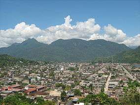
Tingo Maria National Park
| Tingo Maria National Park | |
|---|---|
| Parque Nacional Tingo María | |
|
IUCN category II (national park) | |
|
View of Pumarinri (or La Bella Durmiente), a limestone mountain range in the shape of a sleeping woman in Tingo Maria National Park | |
 Map of Peru | |
| Location | Huánuco Region, Peru |
| Coordinates | 9°22′37″S 75°59′53″W / 9.377°S 75.998°W[1]Coordinates: 9°22′37″S 75°59′53″W / 9.377°S 75.998°W[2] |
| Area | 4,777 hectares (18.44 sq mi) |
| Established | May 14, 1965 (by LEY-15574) |
| Governing body | SERNANP |
The Tingo Maria National Park (Spanish: Parque Nacional Tingo María) is located in the José Crespo Y Castillo District, Huánuco Region, Peru.[3] It was established on May 14,1965.[3] Its principal attraction is the Owl Cave (Spanish: Cueva de las Lechuzas) where the guacharos live. The park has an area of 4,777 hectares (18.44 sq mi)[3] with a mountain range named Pumarinri (Quechua for "cougar ear") or La Bella Durmiente (Spanish for Sleeping Beauty). National tourists and lovers of nature visit the park daily.
Four miles down the Huallaga river is the picturesque city of Tingo Maria; it has a paved airport which is served daily by jet and turbo prop airplanes. The park is under the control of SERNANP and the UNAS[4] with headquarters in Tingo Maria.
See also
References
- ↑ "Tingo María National Park". protectedplanet.net.
- ↑ "Tingo María National Park". protectedplanet.net.
- 1 2 3 "Tingo María" (in Spanish). SERNANP. Retrieved January 27, 2016.
- ↑ National University of the Forest
