Tivoli, New York
| Tivoli, New York | ||
| Village | ||
 Downtown Tivoli, looking east | ||
|
||
| Name origin: Jardin de Tivoli, Paris | ||
| Motto: A Community That Cares | ||
| Country | United States | |
|---|---|---|
| State | New York | |
| Region | Hudson Valley | |
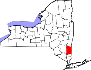
| County | Dutchess | |
| Town | Red Hook | |
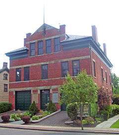
| Landmark | Watts De Peyster Fireman's Hall | |
| River | Hudson | |
| Elevation | 151 ft (46 m) | |
| Coordinates | 42°3′34″N 73°54′38″W / 42.05944°N 73.91056°WCoordinates: 42°3′34″N 73°54′38″W / 42.05944°N 73.91056°W | |
| Highest point | Northeast corner | |
| - elevation | 190 ft (58 m) | |
| - coordinates | 42°3′30″N 73°53′47″W / 42.05833°N 73.89639°W | |
| Lowest point | Sea level | |
| - location | Hudson River | |
| - elevation | 0 ft (0 m) | |
| Area | 4.24 km2 (2 sq mi) | |
| - land | 4.17 km2 (2 sq mi) | |
| Population | 1,118 (2010) | |
| Density | 268.1/km2 (694/sq mi) | |
| Incorporated | 1872 | |
| Government | Village Hall | |
| Mayor | Joel R. Griffith | |
| Timezone | Eastern (EST) (UTC-5) | |
| - summer (DST) | EDT (UTC-4) | |
| ZIP Code | 12583 | |
| Area code | 845 Exchange: 757 | |
| FIPS code | 36-74023 | |
| GNIS feature ID | 0967571 | |
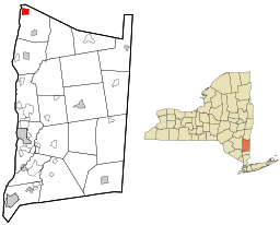
 Location of Tivoli, New York | ||
| Website: www | ||
Tivoli is a village in Dutchess County, New York, United States. The population was 1,118 at the 2010 census.[1] The village, which was incorporated in 1872 from parts of Upper Red Hook Landing and Madalin, is the northernmost settlement in the county, located in the northwest part of the town of Red Hook. It is part of the Poughkeepsie–Newburgh–Middletown, NY Metropolitan Statistical Area as well as the larger New York–Newark–Bridgeport, NY-NJ-CT-PA Combined Statistical Area. It is also entirely within the Hudson River Historic District, a National Historic Landmark. The village is accessible via New York State Route 9G at an intersection with Dutchess County Route 78.
A private liberal arts college, Bard College, is located just south of the village in the hamlet of Annandale-on-Hudson, and the Kaatsbaan International Dance Center[2] is located within the village boundaries.
History
The region was part of the Schuyler Patent, a 1788 patent defining some of the towns and villages in Dutchess County and the Poughkeepsie regional area. The village was formerly known as "Upper Red Hook Landing". An adjacent community, "Madalin", was contiguous to Upper Red Hook Landing. The village of Tivoli was incorporated in 1872, consolidating Madalin and Upper Red Hook Landing. The village government sits in an old firehouse which was constructed by General John Watts de Peyster.
Geography
Tivoli is located in the northwest corner of Dutchess County at 42°3′34″N 73°54′38″W / 42.05944°N 73.91056°W (42.059370, −73.910663).[3]
According to the United States Census Bureau, the village has a total area of 1.64 square miles (4.24 km2), of which 1.61 square miles (4.17 km2) is land and 0.03 square miles (0.07 km2), or 1.69%, is water.[1]
Transportation
Major roads
Several two-lane highways traverse Tivoli. County Route 78—formerly New York State Route 402—is known as Broadway, Route 78 within the village. CR 78 ends at the Hudson River. At one time a ferry crossed the Hudson from there to Saugerties in Ulster County.[4] The second highway, New York State Route 9G, runs along the eastern village border and has an intersection with CR 78.[5] Route 9G leads north 19 miles (31 km) to the city of Hudson and south 27 miles (43 km) to Poughkeepsie, the Dutchess County seat.
Public transportation
Tivoli is served by the route "C" bus run by Dutchess LOOP.[6][7]
Government

The government of Tivoli is made up of five elected officials, who meet at the Watts dePeyster Hall. The hall is part of the village municipal campus, and contains the village offices.[8] The current elected officials in Tivoli are:
| Elected position[8] | Current official[8] |
|---|---|
| Mayor | Joel R. Griffith |
| Deputy Mayor | Emily Majer |
| Trustees | Susan Ezrati, Jeanann Baldasty Schneider, Christopher Murphy |
Demographics
| Historical population | |||
|---|---|---|---|
| Census | Pop. | %± | |
| 1870 | 452 | — | |
| 1880 | 1,254 | 177.4% | |
| 1890 | 1,350 | 7.7% | |
| 1900 | 1,153 | −14.6% | |
| 1910 | 1,034 | −10.3% | |
| 1920 | 876 | −15.3% | |
| 1930 | 713 | −18.6% | |
| 1940 | 761 | 6.7% | |
| 1950 | 753 | −1.1% | |
| 1960 | 732 | −2.8% | |
| 1970 | 739 | 1.0% | |
| 1980 | 711 | −3.8% | |
| 1990 | 1,035 | 45.6% | |
| 2000 | 1,163 | 12.4% | |
| 2010 | 1,118 | −3.9% | |
| Est. 2015 | 1,099 | [9] | −1.7% |
As of the census[11] of 2000, there were 1,163 people, 487 households, and 261 families residing in the village. The population density was 662.1 people per square mile (255.1/km²). There were 531 housing units at an average density of 302.3 per square mile (116.5/km²). The racial makeup of the village was 95.70% White, 0.43% African American, 0.17% Native American, 0.95% Asian, 0.69% from other races, and 2.06% from two or more races. Hispanic or Latino of any race were 2.92% of the population.
There were 487 households out of which 30.0% had children under the age of 18 living with them, 40.7% were married couples living together, 9.4% had a female householder with no husband present, and 46.4% were non-families. Of all households 31.4% were made up of individuals and 8.0% had someone living alone who was 65 years of age or older. The average household size was 2.38 and the average family size was 3.10.
In the village the population was spread out with 23.8% under the age of 18, 16.8% from 18 to 24, 28.7% from 25 to 44, 20.5% from 45 to 64, and 10.2% who were 65 years of age or older. The median age was 34 years. For every 100 females there were 84.6 males. For every 100 females age 18 and over, there were 79.4 males.
The median income for a household in the village was $40,536, and the median income for a family was $53,393. Males had a median income of $41,375 versus $26,000 for females. The per capita income for the village was $20,478. About 6.2% of families and 17.5% of the population were below the poverty line, including 11.9% of those under age 18 and 3.8% of those age 65 or over.
See also
-
 Hudson Valley portal
Notes
- 1 2 "Geographic Identifiers: 2010 Demographic Profile Data (G001): Tivoli village, New York". U.S. Census Bureau, American Factfinder. Retrieved November 16, 2015.
- ↑ http://www.kaatsbaan.org/
- ↑ "US Gazetteer files: 2010, 2000, and 1990". United States Census Bureau. 2011-02-12. Retrieved 2011-04-23.
- ↑ Overview map of CR 78 (former NY 402) (Map). Cartography by NAVTEQ. Google Maps. Retrieved 2008-06-15.
- ↑ 1977-2007 I love New York state map (Map). I Love New York. 2007.
- ↑ http://www.co.dutchess.ny.us/CountyGov/Departments/MassTransit/looprtcmonsat.pdf
- ↑ http://www.dutchessny.gov/loopbus/
- 1 2 3 Village Government (Map). Tivoli, New York. Retrieved 2008-06-15.
- ↑ "Annual Estimates of the Resident Population for Incorporated Places: April 1, 2010 to July 1, 2015". Retrieved July 2, 2016.
- ↑ "Census of Population and Housing". Census.gov. Retrieved June 4, 2015.
- ↑ "American FactFinder". United States Census Bureau. Retrieved 2008-01-31.

