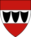
Třebíč
| Třebíč | |||
| Town | |||
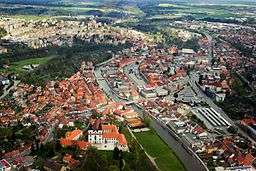 Aerial view of center of Třebíč | |||
|
|||
| Name origin: from name Třebek | |||
| Nickname: Třeb | |||
| Country | Czech Republic | ||
|---|---|---|---|
| Region | Vysočina | ||
| District | Třebíč | ||
| Commune | Třebíč | ||
| River | Jihlava | ||
| Elevation | 405 m (1,329 ft) | ||
| Coordinates | CZ 49°13′N 15°52′E / 49.217°N 15.867°ECoordinates: CZ 49°13′N 15°52′E / 49.217°N 15.867°E | ||
| Area | 57.6 km2 (22.2 sq mi) | ||
| Population | 36,880 (2015) | ||
| Density | 640/km2 (1,658/sq mi) | ||
| First mentioned | 1277 | ||
| Mayor | Pavel Janata | ||
| Timezone | CET (UTC+1) | ||
| - summer (DST) | CEST (UTC+2) | ||
| Postal code | 674 01 | ||
| UNESCO World Heritage Site | |||
| Name | Jewish Quarter and St. Procopius' Basilica in Trebíc | ||
| Year | 2003 (#27) | ||
| Number | 1078 | ||
| Region | Europe and North America | ||
| Criteria | ii, iii | ||
  Location in the Czech Republic | |||
| Wikimedia Commons: Třebíč | |||
| Statistics: statnisprava.cz | |||
| Website: www.trebic.cz | |||
Třebíč (Czech pronunciation: [ˈtr̝̊ɛbiːtʃ]; German: Trebitz) is a town in the Moravian part of the Vysočina Region of the Czech Republic.
Třebíč is situated 35 km southeast of Jihlava and 65 km west of Brno on the Jihlava River. Třebíč is from 392 to 503 metres above sea-level.
Třebíč has a temperate climate with occasional rains. Average annual temperature is 7.5°C, average temperature in July is 18.5°C and -3.4°C in January.
Třebíč is a regional centre with a population of approximately 40,000. In the age of expansion, Třebíč was third most important town in Moravia. The population growth started after World War II. Třebíč is an important regional center today.
There are many sights. The Jewish Quarter and St. Procopius Basilica is listed as a UNESCO World Heritage Site.
History and sights
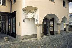
This includes the old Jewish Quarter and the largely Romanesque St Procopius' Basilica that incorporates some later gothic features, including a rare example of a ten-part or 'botanical' rose window. Such designs reflect the five or ten parts of the roseaceae family flowers and fruit, based on their five sepals and petals or the usual ten segments of their fruit. Botanical rose windows contrast with more complex Gothic windows that contain more segments (usually multiples of traditional gothic units of design - three trefoil, or four quatrefoil), or are based on ancient design inspiration from forerunners of the wheel of life which is now associated with eastern religions, or may allude to the Virgin Mary.
The famous Basilica originated in the early 12th century as a Benedictine monastery. It was so well endowed that it led to the establishment of a local commercial centre; the town of Trebic. The monastery was rebuilt during the reign of King Wenceslas I (1230–53), and again at the end of the fifteenth century. During the first half of the 16th century some of Trebic's historic monastic buildings were remodelled as a castle, and later renovated in baroque style.
In the early eighteenth century changes were introduced to the basilica by Czech architect, Frantisek Maxmilian Kanka; windows were enlarged, buttresses added, a south-west tower was rebuilt, and a new west front with two towers was constructed in a gothic baroque style.
The historic town of Trebic, which extends on both sides of the river Jihlava, was declared a Conservation Area in 1990. The Jewish Quarter and St. Procopius Basilica with the castle and gardens, are all included within the Trebic Conservation Area.
Gallery
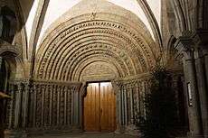 Portal of St Procopius' Basilica
 Interior of the St. Prokops Bazilique in Třebíč
 Abbacy of St Procopius' Basilica in Třebíč
- Interior of Jewish Synagogue, Třebíč
- Statue, Saints Cyril and Methodius
History in dates
- 1101 Establishment of Benedictine Monastery.
- 1277 The oldest deed mentioning the town of Třebíč.
- 1335 Conferring of town rights to Třebíč according to the royal town of Znojmo.
- 1338 First references of Jewish settlement.
- 1468 Třebíč was conquered and destroyed by Matthias Corvinus of Hungary.
- 19th century Expansion of tannery and shoemaking.
- 1871 Opening of Národní dům (National House), establishment of grammar school with Czech as teaching language (Gymnázium Třebíč).
- 1886 First train runs through Třebíč.
- 1930 Development of shoe making production and construction of workers' colonies - present Borovina
- 1970s - 80s The town is stigmated by the construction of new housing estates, population increases.
- 1990s Fast renovation of the town.
- 2003 Registration of Jewish Quarter and St. Procopius' Basilika into UNESCO List of Cultural and Natural Heritage
Demography
| Progress of population[1][2] | |||
|---|---|---|---|
| Year | Population | ||
| 1763 | 3 149 | ||
| 1772 | 3 439 | ||
| 1791 | 4 743 | ||
| 1799 | 5 010 | ||
| 1830 | 6 005 | ||
| 1835 | 6 731 | ||
| 1843 | 6 803 | ||
| 1849 | 7 800 | ||
| 1850 | 8 002 | ||
| 1869 | 10 328 | ||
| 1880 | 11 999 | ||
| 1890 | 13 726 | ||
| 1900 | 15 309 | ||
| 1910 | 16 347 | ||
| 1921 | 17 191 | ||
| 1930 | 17 555 | ||
| 1950 | 20 257 | ||
| 1960 | 20 387 | ||
| 1970 | 22 555 | ||
| 1980 | 29 017 | ||
| 1985 | 36 008 | ||
| 1991 | 38 355 | ||
| 2001 | 39 021 | ||
| 2005 | 38 715 | ||
| 2008 | 38 717 | ||
Town districts
- Borovina (526 houses, 5 864 inhabitant)
- Budíkovice (61 houses, 199 inhabitant)
- Horka Domky (1 158 houses, 7 788 inhabitant)
- Jejkov (91 houses, 270 inhabitant)
- Nové Dvory (987 houses, 16 657 inhabitant)
- Nové Město(161 houses, 1056 inhabitant)
- Pocoucov (59 houses, 183 inhabitant)
- Podklášteří (1 009 houses, 3 899 inhabitant)
- Ptáčov (66 houses, 212 inhabitant)
- Račerovice (49 houses, 155 inhabitant)
- Řípov (22 houses, 68 inhabitant)
- Slavice (80 houses, 246 inhabitant)
- Sokolí (44 houses, 88 inhabitant)
- Stařečka (202 houses, 539 inhabitant)
- Týn (203 houses, 1 171 inhabitant)
- Vnitřní Město (53 houses, 210 inhabitant)
- Zámostí (124 houses, 416 inhabitant)
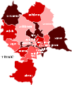 Map of town districts in Třebíč
Transit
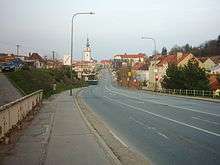
Important trade routes leading near Třebíč already in ancient times were called: Habry Route, Lovětín Route and Libice Route.
Today Třebíč is an important traffic junction of the region. The main roads crrossing Třebíč are I/23 (Brno - České Budějovice) and II/360, which connects Třebíč with the highway D1. Near the town is road II/405, which connect the town with capital town of Vysočina Region - Jihlava.
The railway has the east-west direction in Třebíč. This railway No. 240 connects Třebíč with cities Brno and Jihlava. One can find two stations here: Třebíč and Třebíč-Borovina.
Outside the town there is the small sport airport.
The trolley was projected in the history in Třebíč but has never been realised.
In Třebíč there are several segregated cycle facilities and in year 2009 there will be finished a new bike route leading from Jihlava to Raabs an der Thaya.
Culture
Festivals
- Theatre Třebíč (Divadelní Třebíč) - festival of Amateur theatre
- Šamajim - festival of Jewish culture
- Třebíč potato festival (Bramborobraní) - folklore festival - music and dance
- Jubilee Unesco (Oslavy Unesco) - jubilee celebration of town entrance to the UNESCO list
- Theatre 2-3-4 actors (Divadla 2-3-4 herců) - festival of professional theatre
- Zámostí - cultural and music festival[3]
- Concentus Moraviae - concerts of classical music
People
- born here
- Patrik Eliáš, ice hockey player
- Martin Erat, ice hockey player
- Pavel Padrnos, professional road racing cyclist
- Vladimir Sobotka, ice hockey player
- Jan Zahradníček, Czech poet, born in Mastník, near Třebíč
- Jan Syrový, Czechoslovak general and politician, prime minister (1938)
- Jaroslav Zvěřina, Czech politician
- Jindřich Svoboda (aviator) (1917–1942), a Czech bomber captain in the RAF
- Theodor Gebre Selassie, first black player to represent the Czech Republic at any level internationally
- Jitka Válková, Czech Republic, Top 15 at Miss Universe 2010
- other residents
- Leopold Löw, Moravia-born rabbi, received his preliminary education at the yeshibot of Trebitsch
- William Hosking, writer, lecturer
Schools
- Universities
- Secondary schools
- Gymnázium Třebíč (Gymnasium Třebíč)[5]
- Střední průmyslová škola Třebíč (Second industrial school Třebíč)[6]
- Katolické gymnázium Třebíč (Catholic gymnasium Třebíč)[7]
- Obchodní akademie Dr. Albína Bráfa[8]
- Vyšší odborná škola a Střední škola veterinární, zemědělská a zdravotnická Třebíč[9]
- Hotelová škola Třebíč[10]
- Střední škola stavební Třebíč[11]
- Střední škola řemesel Třebíč[12]
- Soukromá střední odborná škola a Střední odborné učiliště
Partnership towns[13]
References
- ↑ Soubor školních map 1:100 000 - OKRES TŘEBÍČ, Kolektiv autorů, Geodetický a kartografický ústav v Praze, n. p. for ONV Třebíč, 1987, First edition, 20/34 pages, language: czech
- ↑ Třebíč - Dějiny města II, Jan Janák, illustrations Božena and Josef Kremláček, Blok Brno for ZMM in Třebíč, 1981, First edition, 224 pages, language: czech
- ↑ Zamosti.cz Zamosti.cz
- ↑ ZMVS.cz (Czech) (German) (English)
- ↑ GTR.cz
- ↑ Spst.cz
- ↑ KGtrebic.cz
- ↑ Oatrebic.cz
- ↑ Szstrebic.cz
- ↑ Sosos.cz
- ↑ Spsstavebni.trebic.net
- ↑ Sour-tr.euweb.cz
- ↑ Outcome of the questionnaire with statement of partnership towns
External links
| Wikimedia Commons has media related to Třebíč. |
- Municipal website in English
- Trebic.cz/unesco - UNESCO in Třebíč town (cz, de, en, fr)
- Zamek-trebic.cz - Vysočina Museum in Třebíč (cz)
- Basilica of St. Procopius in Třebíč (en)
- Jewish Ghetto in Třebíč (en)

