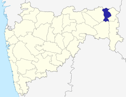
Tumsar
| Tumsar तुमसर | |
|---|---|
| city | |
 Tumsar Location in Maharashtra, India | |
| Coordinates: 21°22′50″N 79°44′50″E / 21.38056°N 79.74722°ECoordinates: 21°22′50″N 79°44′50″E / 21.38056°N 79.74722°E | |
| Country |
|
| State | Maharashtra |
| District | Bhandara |
| Government | |
| • MLA | Charan Waghmare |
| Elevation | 272 m (892 ft) |
| Population (2011)[1][2] | |
| • Total |
Town of Tumsar: 42,021 Taluka of Tumsar: 213,843 |
| Languages | |
| • Official | Marathi |
| Time zone | IST (UTC+5:30) |
| PIN | 441912 |
| Telephone code | 91-7183 |
| Vehicle registration | MH36 |
| CSC Tumsar | |
Tumsar is a town in the Bhandara district in the Indian state of Maharashtra. The main language of Tumsar is Marathi.
Transport
Tumsar's railway station is on the Tirodi Line. The main railway station, Tumsar Road, is in Dewhadi, 5 km away from the town on the Howrah-Nagpur-Mumbai line. Two trains connect Trivandrum with Tumsar, running 3-4 days a week.[3]
Demographics
In the 2011 census, Tumsar had a population of 42,021 people in 8,462 households,[1] while the population of the surrounding taluka was 213,843 people in 44,191 households.[2]
Religion
List of religions by number of people:
- Hinduism - 37,828
- Islam - 2,323
- Christianity 91
- Sikhism - 6
- Buddhism - 4,208
- Jainism - 159
- Others - 46
- Not stated - 208
References
- 1 2 View Population Details. The Registrar General & Census Commissioner, India, New Delhi, Ministry of Home Affairs, Government of India. Accessed July 2016.
- 1 2 Sub-District Details. The Registrar General & Census Commissioner, India, New Delhi, Ministry of Home Affairs, Government of India. Accessed July 2016.
- ↑ "Trains recently added to the Site". India Rail Info. Retrieved 2016-06-29.
 |
Pench National Park, Madhya Pradesh city Seoni | Balaghat(Madhya Pradesh) |  | |
| Ramtek(Nagpur district) | |
Wainganga River, Gondia | ||
| ||||
| | ||||
| Mohadi | Bhandara | Tirora(Gondia district) |
This article is issued from Wikipedia - version of the 11/30/2016. The text is available under the Creative Commons Attribution/Share Alike but additional terms may apply for the media files.
