Typhoon Sinlaku (2008)
| Typhoon (JMA scale) | |
|---|---|
| Category 4 (Saffir–Simpson scale) | |
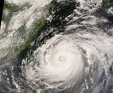
 Typhoon Sinlaku on September 10, 2008, approaching Taiwan at peak strength. | |
| Formed | September 8, 2008 |
| Dissipated | September 25, 2008 |
| (Extratropical after September 21) | |
| Highest winds |
10-minute sustained: 185 km/h (115 mph) 1-minute sustained: 230 km/h (145 mph) |
| Lowest pressure | 935 hPa (mbar); 27.61 inHg |
| Fatalities | 12 direct, 2 indirect, 10 missing |
| Damage | $1.1 billion (2008 USD) |
| Areas affected | Philippines, Taiwan, People's Republic of China, Japan |
| Part of the 2008 Pacific typhoon season | |
Typhoon Sinlaku, known in the Philippines as Typhoon Marce, was a typhoon which affected the Philippines, Taiwan, China and Japan. It was recognised as the 13th named storm and the ninth typhoon of the 2008 Pacific typhoon season by the Japan Meteorological Agency.
The name Sinlaku was one of the ten original names submitted to the WMOs Typhoon Committee for use from January 1, 2000 by Micronesia. It was last used in the 2002 Pacific typhoon season to name a tropical storm and is the name of a goddess worshipped on the island of Kosrae in Micronesia.[1] Note that the name is apparently shortened (a seemingly routine practice of making names easier to read to Westerners) from the original "Sin Laku."[2]
Meteorological history

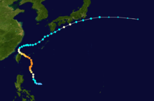
On September 7, 2008, a tropical disturbance formed to the northeast of Manila in the Philippines.[3] It was initially forecasted not to intensify into a tropical depression within 24 hours.[3] However it was upgraded to a tropical depression early the next morning with both PAGASA & the JMA designating it as a minor tropical depression with PAGASA naming the depression as Marce.[4][5] Meanwhile, the Joint Typhoon Warning Center (JTWC) issued a Tropical Cyclone Formation Alert on the developing depression.[6] Later that day PAGASA upgraded the depression to a tropical storm whilst the JMA started to issue full advisories on the depression. That afternoon the JTWC designated the depression as Tropical Depression 15W.[7][8] During that evening the depression had intensified into a tropical storm and was named Sinlaku by the JMA. The JTWC also upgraded the depression to a tropical storm that evening.[9][10][11]

Early on September 9 the JMA upgraded Sinlaku to a Severe Tropical Storm. [12] Whilst during that afternoon the JTWC reported that Sinlaku had intensified into a Typhoon, the JMA then upgraded Sinlaku to a typhoon later that day.[13][14] The JTWC then reported Sinlaku had intensified into a category two typhoon. During the next day Sinlaku continued to intensify and reached its maximum 1 minute sustained winds of 125 knots which made it a Category 4 typhoon. It stayed at this intensity until the next day when it started to weaken as it went through an eye wall replacement cycle. Sinlaku then struggled to come out of its eye wall replacement cycle and as a result weakened into a Category 3 typhoon. The weakening trend continued until on September 13 Typhoon Sinlaku made landfall on Taiwan as a Category 2 typhoon. It moved towards the North West through Taiwan and then turned towards the north east and moved back into the South China Sea and started moving slowly towards Japan.
Early on September 14, the JMA downgraded Sinlaku to a severe tropical storm. Meanwhile, the JTWC were reporting that Sinlaku was a weak Category 1 typhoon. Later that day PAGASA issued their final advisory on Sinlaku as Sinlaku moved out of its area of responsibility. Late the next day the JTWC downgraded Sinlaku to a Tropical storm and then early on September 16 the JMA then downgraded Sinlaku into a tropical storm whilst Sinlaku moved closer to Japan. On September 17 Sinlaku strengthened into a severe tropical storm whilst the JTWC reported that Sinlaku had regained Typhoon strength, However, later that day the JTWC downgraded sinlaku to a Tropical storm again. However early the next day the JTWC reported that Sinlaku had once again regained Typhoon intensity however the JTWC downgraded Sinlaku to a tropical storm. Early on September 20, the JTWC issued its final advisory on Tropical Storm 15W as the storm became extratropical. Later that day the JMA, downgraded Sinlaku to a tropical storm.[15] Early on September 21 the JMA downgraded Sinlaku to an extra tropical low as it moved further away from Japan.[16]
Preparations
Philippines
| Signals No.1 & 2 | Signal No.1 |
|---|---|
| Babuyan | Polillo Island |
| Batanes islands | CAR |
| Cagayan | Cagayan Valley |
| Isabela | Aurora |
On September 8 PAGASA started to issue Public Storm warnings on Typhoon Marce (Sinlaku). Pagasa immediately hoisted Public Storm warning 1 over parts of Luzon including the Bicol, Isabela, Aurora & Cagayan Regions.[5] Later that day PAGASA hoisted further Signal one's for otber parts of Luzon and raised the Public storm warning from No.1 to No.2 for Cagayan & Isabela [17] Early the next day PAGASA downgraded Signal No.2 to No.1 for Isabela & hoisted Signal No.2 for Babuyan as well as downgrading some of the No.1 signals for other parts of Luzon [18] Later that day PAGASA downgraded the signal from No.2 to No.1 for Cagayan and further downgraded some of the other signals.[19] They then kept these signals in place until late on September 10 when they downgraded the signal for Babuyan Island.[20] Late the next day they downgraded all of the signals except for Batanes Island which remained under Signal No.1, until early the next day when PAGASA removed the signal.[21][22]
Taiwan

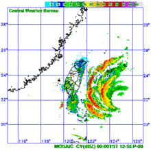
On September 10 the Central Weather Bureau (CWB) issued warnings for heavy rain in north Taiwan.[23] then on September 11 the CWB decided to issue sea warnings which meant that ships that were sailing within the Bashi Channel had to take extra precautions.[24] Land Warnings were then issued the next morning as Sinlaku moved closer to Taiwan.[25]
Japan
On September 9 the JMA started to issue Storm warnings for Naha on Okinawa and the seas south of Okinawa.[26] Later that day the JMA upgraded the storm warnings to Typhoon warnings whilst Sinlaku moved further north [27] During the next day the Joint Typhoon Warning Center raised the Tropical Cyclone Condition of Readiness (TCCOR) from TCCOR 4 to TCCOR 3 for Okinawa which meant that wind speeds greater than 50 knots were possible within 48 hours.[28][29] The JMA kept these issuing the typhoon warnings until September 14 when they downgraded it to a Storm warning [30] The JTWC kept the TCCOR in force until September 15 when they lowered TCCOR 3 to TCCOR 4 which meant that wind speeds greater than 50 knots were possible within 72 hours.[29][31] the JMA also upgraded their storm warnings to typhoon warnings however these typhoon warnings were downgraded to storm warnings later that day [32][33] Late on September 17 as Sinlaku moved closer to Japan the JMA added the Moji & Yokohama areas to the warnings [34] Early on September 19 the JMA added Otaru and Kushiro to the storm warnings [35] Later that day the JMA revised their storm warnings by removing the warnings for Kushiro, Moji, Naha & Otaru.[36]
Impact
| Precipitation | Storm | Location | Ref. | ||
|---|---|---|---|---|---|
| Rank | mm | in | |||
| 1 | 3,060 | 120.47 | Morakot 2009 | Alishan, Chiayi | [37] |
| 2 | 2,319 | 91.30 | Nari 2001 | Wulai, New Taipei | [38] |
| 3 | 2,162 | 85.12 | Flossie 1969 | Beitou, Taipei | [37] |
| 4 | 1,987 | 78.23 | Herb 1996 | Alishan, Chiayi | [39] |
| 5 | 1,774 | 69.84 | Saola 2012 | Yilan City | [40] |
| 6 | 1,700 | 66.93 | Lynn 1987 | Taipei | [41] |
| 7 | 1,672 | 65.83 | Clara 1967 | Dongshan, Yilan | [42] |
| 8 | 1,611 | 63.43 | Sinlaku 2008 | Heping, Taichung | [43] |
| 9 | 1,561 | 61.46 | Haitang 2005 | Sandimen, Pingtung | [44] |
| 10 | 1,546 | 60.87 | Aere 2004 | Miaoli County | [45] |
Sinlaku brought torrential and almost endless rain over most of Luzon from September 8 to the 11th. It caused floods especially in the province of Zambales, forcing some people to evacuate. At least 12 people were killed and another 10 were reported as missing in Taiwan. Two others were found in a river as officials searched for the missing. They're considered to have been killed by an event related to Sinlaku.[46] A large section of a 2,000 ft bridge collapsed with five people on it after heavy rain caused supports to break. Three other bridges were washed out. Three people were killed after a large landslide over a tunnel caused it to collapse.[47] The storm caused at least $22.2 million in damages to agriculture.[46] About 120,000 residences lost power during the storm. During the storm, 1,000 people were evacuated from low-lying areas which were at risk from flooding.[48]
See also
References
- ↑ "The meaning of new tropical cyclone names in 2004". HKO. Retrieved 2008-09-10.
- ↑ "Reversing Paradigm" (in Korean). Retrieved 6 March 2013.
- 1 2 "ABPW10 PGTW 07-09-08". JTWC. Retrieved 2008-09-10.
- ↑ "JMA Advisory 07-09-08 00Z". JMA. Retrieved 2008-09-10.
- 1 2 "PAGASA Advisory 07-09-08 03Z". PAGASA. Archived from the original on September 8, 2008. Retrieved 2008-09-10.
- ↑ "Tropical Cyclone Formation Alert". JTWC. Retrieved 2008-09-10.
- ↑ "PAGASA Advisory 08-09-08 09Z". PAGASA. Archived from the original on September 8, 2008. Retrieved 2008-09-10.
- ↑ "JMA Advisory 08-09-08 06Z". JMA. Archived from the original on September 9, 2008. Retrieved 2008-09-10.
- ↑ "JTWC Advisory 08-09-08 15Z". JTWC. Retrieved 2008-09-10.
- ↑ "JMA Advisory 08-09-08 18Z". JMA. Retrieved 2008-09-10.
- ↑ "JTWC Advisory 08-09-08 21Z". JTWC. Retrieved 2008-09-10.
- ↑ "JMA Advisory 09-09-08 06Z". JMA. Retrieved 2008-09-10.
- ↑ "JMA Advisory 09-09-08 18z". JMA. Retrieved 2008-09-10.
- ↑ "JTWC Advisory 09-09-08 15Z". JTWC. Retrieved 2008-09-10.
- ↑ "JMA Advisory 20-09-08 18z". JMA. Retrieved 2008-09-21.
- ↑ "JMA Advisory 21-09-08 00z". JMA. Retrieved 2008-09-21.
- ↑ "PAGASA Advisory 08-09-08 15Z". PAGASA. Archived from the original on September 8, 2008. Retrieved 2008-09-23.
- ↑ "PAGASA Advisory 09-09-08 09Z". PAGASA. Archived from the original on September 9, 2008. Retrieved 2008-09-23.
- ↑ "PAGASA Advisory 09-09-08 21Z". PAGASA. Archived from the original on September 9, 2008. Retrieved 2008-09-23.
- ↑ "PAGASA Advisory 10-09-08 21Z". PAGASA. Archived from the original on September 10, 2008. Retrieved 2008-09-24.
- ↑ "PAGASA Advisory 11-09-08 21Z". PAGASA. Archived from the original on September 11, 2008. Retrieved 2008-09-13.
- ↑ "PAGASA Advisory 12-09-08 09Z". PAGASA. Archived from the original on September 16, 2008. Retrieved 2008-09-13.
- ↑ "CWB issues warnings for Sinlaku". Taiwan News. 2008-09-11. Retrieved 2008-09-14.
- ↑ "CWB watching typhoon after issuing sea warning". China Post. 2008-09-12. Retrieved 2008-09-14.
- ↑ "Brace for the typhoon:CWB". China Post. Retrieved 2008-09-14.
- ↑ "JMA WWJP81 Warning 09-09-08 03z". JMA. Retrieved 2008-09-17.
- ↑ "JMA WWJP81 Warning 09-09-08 15z". JMA. Retrieved 2008-09-17.
- ↑ "TCCOR 3". JTWC. Archived from the original on September 10, 2008. Retrieved 2008-09-10.
- 1 2 "Kadena braces for Typhoon Sinlaku". Kadena Air Base. Retrieved 2008-09-15.
- ↑ "JMA WWJP81 Warning 14-09-08 03z". JMA. Retrieved 2008-09-17.
- ↑ "Typhoon Sinlaku Update". Kadena Air Base. Retrieved 2008-09-15.
- ↑ "JMA WWJP81 Warning 15-09-08 03z". JMA. Retrieved 2008-09-17.
- ↑ "JMA WWJP81 Warning 15-09-08 21z". JMA. Retrieved 2008-09-17.
- ↑ "JMA WWJP81 Warning 17-09-08 21z". JMA. Retrieved 2008-09-17.
- ↑ "JMA WWJP25 Warning 19-09-08 06z". JMA. Retrieved 2008-09-20.
- ↑ "JMA WWJP25 Warning 19-09-08 18z". JMA. Retrieved 2008-09-20.
- 1 2 Central Weather Bureau (2010). "侵台颱風資料庫". Retrieved October 19, 2011.
- ↑ Unattributed (September 9, 2009). "莫拉克颱風暴雨量及洪流量分析" (PDF). Water Resources Agency, Ministry of Economic Affairs, Republic of China. Retrieved July 17, 2011.
- ↑ Unattributed (September 9, 2009). "莫拉克颱風暴雨量及洪流量分析" (PDF). Water Resources Agency, Ministry of Economic Affairs, Republic of China. Retrieved July 17, 2011.
- ↑ Chen Zhi (August 2, 2012). "Typhoon Saola dumps heavy downpours around Taiwan". Xinhua General News. Retrieved August 2, 2012.
- ↑ Joint Typhoon Warning Center; Naval Pacific Meteorology and Oceanography Center (1988). Annual Tropical Cyclone Report: 1987 (PDF) (Report). United States Navy, United States Air Force. Retrieved July 1, 2014.
- ↑ Lianshou, Chen. Topic 2.1 Observing and forecasting rainfall. Fifth International Workshop on Tropical Cyclones. Retrieved August 4, 2012.
- ↑ "Typhoon Sinlaku Central emergency operation center No.12" (PDF). Central emergency operation center. September 16, 2008. Retrieved January 13, 2009.
- ↑ Chiu Yu-Tzu (July 20, 2005). "Haitang fizzles out, leaves Taiwan wet". Taipei Times. Retrieved April 11, 2010.
- ↑ Padgett, Gary. "Monthly Global Tropical Cyclone Summary: November 2004". Retrieved June 10, 2012.
- 1 2 Xinhua News Agency (September 17, 2008). "China: Typhoon death toll rises to 12 in Taiwan, more missing". ReliefWeb. Retrieved March 19, 2009.
- ↑ Associated Press (September 16, 2008). "Powerful Typhoon Sinlaku leaves 11 dead in Taiwan". USA Today. Retrieved March 19, 2009.
- ↑ Annie Huang (September 14, 2008). "Typhoon Sinlaku floods low-lying areas of Taiwan". Guardian Unlimited. Retrieved March 19, 2009.
External links
| Wikimedia Commons has media related to Typhoon Sinlaku (2008). |
- JMA General Information of Typhoon Sinlaku (0813) from Digital Typhoon
- JMA Best Track Data of Typhoon Sinlaku (0813) (Japanese)
- JMA Best Track Data (Graphics) of Typhoon Sinlaku (0813)
- JMA Best Track Data (Text)
- JTWC Best Track Data of Typhoon 15W (Sinlaku)
- 15W.SINLAKU from the U.S. Naval Research Laboratory
