U.S. Route 35 in Ohio
| ||||
|---|---|---|---|---|
|
Route of US 35 in southern Ohio in red | ||||
| Route information | ||||
| Maintained by ODOT | ||||
| Length: | 174.33 mi[1] (280.56 km) | |||
| Existed: | 1926 – present | |||
| Major junctions | ||||
| West end: |
| |||
|
| ||||
| East end: |
| |||
| Location | ||||
| Counties: | Preble, Montgomery, Greene, Fayette, Ross, Jackson, Gallia | |||
| Highway system | ||||
| ||||

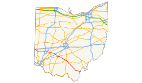
U.S. Route 35 is a United States highway running from northern Indiana to Charleston, West Virginia. Within the state of Ohio, it runs roughly southeast-northwest from the state line near New Paris, Ohio to the Silver Memorial Bridge across the Ohio River at Gallipolis.
Route description
US 35 enters Ohio from the west in concurrency with Interstate 70, departing at that route's Exit 1 just across the state line.The road angles southeasterly into Eaton, then runs due east-west to Drexel, at which point it becomes a limited access expressway. It continues as a freeway through the east side of Dayton, except a small portion east of Dayton, also bypassing Xenia to the south, Jamestown to the north, and Washington Court House to the south. It then bypasses Chillicothe to the north and east, partially in concurrency with US 23, then angles southeasterly again, with the freeway portion ending at Richmond Dale. From there southeasterly and easterly to Gallipolis, it is a divided highway with a mix of interchanges and at-grade intersections.
History
Before the adoption of the U.S. highway system in 1926, the route was known in its entirety as SR 11.[2] By 1966, the first freeway portion of the route began construction, comprising the Chillicothe bypass.[3] Freeway portions on the east side of Dayton and south side of Xenia were completed by 1971,[4] and around Washington Court House by 1974.[5]
Major intersections
All exits are unnumbered.
| County | Location | mi[1] | km | Destinations | Notes |
|---|---|---|---|---|---|
| Preble | Jefferson–Jackson township line | 0.00 | 0.00 | Indiana state line | |
| 1.66 | 2.67 | Eastbound exit and westbound entrance; exit 1 on I-70; east end of I-70 overlap | |||
| Jackson Township | 2.38 | 3.83 | Southern terminus of SR 320 | ||
| Eaton | 11.42 | 18.38 | Western end of SR 122 overlap; no right turn for trucks from eastbound US 35 to westbound SR 122 | ||
| 11.68 | 18.80 | Northern terminus of SR 732 | |||
| 11.92 | 19.18 | Eastern end of SR 122 overlap | |||
| West Alexandria | 17.22 | 27.71 | |||
| Montgomery | Jefferson Township–Trotwood municipal line | 30.22 | 48.63 | Southern terminus of SR 49; western end of expressway | |
| Dayton | 32.59 | 52.45 | Gettysburg Avenue | ||
| 34.31 | 55.22 | James H. McGee Boulevard | |||
| 35.30 | 56.81 | Exits to southbound I-75 and entrances from northbound I-75 also provide complete access to Stewart Street | |||
| Bridge over the Great Miami River | |||||
| 35.97 | 57.89 | Perry Street, Ludlow Street | |||
| 36.19 | 58.24 | ||||
| 36.94 | 59.45 | Keowee Street, Wayne Avenue | No direct access from northbound Keowee Street to westbound US 35; westbound exit is attached to Steve Whalen Boulevard exit | ||
| 37.84 | 60.90 | Steve Whalen Boulevard | |||
| 39.00 | 62.76 | Smithville Road | |||
| Greene | Beavercreek | Western terminus of SR 835 | |||
| Linden Avenue | Eastbound exit and westbound entrance | ||||
| Westbound uses collector/distributor lane. Exits 13A-B on I-675. | |||||
| Separate eastbound exit for SR 835/Research Boulevard; eastern terminus of SR 835 | |||||
| Eastern end of freeway | |||||
| Xenia Township–Xenia municipal line | Interchange | ||||
| Xenia | Western end of freeway | ||||
| Lower Bellbrook Road | |||||
| Xenia Township–Xenia municipal line | |||||
| Xenia Township | Bickett Road | Eastern terminus of BUS US 35 | |||
| Silvercreek Township | Old US 35 — Jamestown | ||||
| Fayette | Jefferson Township | Western terminus of SR 435; eastbound exit and westbound entrance | |||
| Westbound exit and eastbound entrance | |||||
| Union Township | Palmer Road | ||||
| Ross | Concord Township | ||||
| County Road 87 — Frankfort | |||||
| Union Township | County Road 550 — Pleasant Valley | ||||
| Westbound exit and eastbound entrance | |||||
| Chillicothe | |||||
| Westbound exit and eastbound entrance; west end of US 23 overlap | |||||
| Scioto Township | Eastbound exit and westbound entrance; east end of US 23 overlap | ||||
| Westbound exit and eastbound entrance | |||||
| Scioto–Liberty township line | East end of US 50 overlap | ||||
| Jefferson Township | Vigo Road, Watson Road — Richmond Dale | ||||
| Western end of freeway | |||||
| Jackson | Coal Township | County Road 84, Chillicothe Pike, Jackson Business Route | Jackson Business Route signed eastbound only; CR 84 and Chillicothe Pike signed westbound only | ||
| Lick Township | |||||
| Pattonsville Road, Broadway Street | |||||
| Jackson | |||||
| Bloomfield Township | Grade separation; southern terminus of SR 327 | ||||
| Gallia | Raccoon Township | Eastern terminus of SR 279 | |||
| Eastern end of freeway | |||||
| Springfield Township | |||||
| Eastbound exit and westbound entrance | |||||
| Green–Gallipolis township line | No eastbound exit | ||||
| Gallipolis Township | Eastbound exit and westbound entrance; western terminus of SR 735 | ||||
| Westbound exit and eastbound entrance | |||||
| Gallipolis | 174.33 | 280.56 | Silver Memorial Bridge over the Ohio River | ||
1.000 mi = 1.609 km; 1.000 km = 0.621 mi
| |||||
References
- 1 2 "DESTAPE". Ohio Department of Transportation. July 3, 2014. Retrieved February 5, 2015. Preble, Montgomery, Greene, Fayette, Ross, Jackson, Gallia.
- ↑ Ohio Department of Highways and Public Works (August 1925). Map of Ohio Showing State Routes (MrSID) (Map). 1:760,320. Columbus: Ohio Department of Highways and Public Works. OCLC 5673562.
- ↑ Ohio Department of Highways (1966). Official Highway Map of Ohio (MrSID) (Map). Columbus: Ohio Department of Highways. § G13. OCLC 5673562.
- ↑ Ohio Department of Highways (1971). Official Highway Map of Ohio (MrSID) (Map). 1:554,400. Columbus: Ohio Department of Highways. §§ C12–D12. OCLC 5673562.
- ↑ Ohio Department of Transportation (1974). Official Highway Map of Ohio (MrSID) (Map). 1:554,400. Columbus: Ohio Department of Transportation. § F12. OCLC 5673562.
| Previous state: Indiana |
Ohio | Next state: West Virginia |