Ugarchin Point
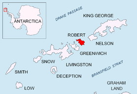
Location of Robert Island in the South Shetland Islands.
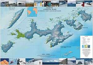
Topographic map of Livingston Island, Greenwich, Robert, Snow and Smith Islands.
Ugarchin Point (Bulgarian: нос Угърчин, ‘Nos Ugarchin’ \'nos u-g&r-'chin\) is a point on the northeast coast of Robert Island in the South Shetland Islands, Antarctica projecting 300 m into Nelson Strait. Named after the town of Ugarchin in northern Bulgaria.
Location
The point is located at 62°22′01″S 59°28′12″W / 62.36694°S 59.47000°WCoordinates: 62°22′01″S 59°28′12″W / 62.36694°S 59.47000°W, which is 4.7 km west of Smirnenski Point and 4.2 km southeast of Newell Point (Bulgarian early mapping in 2009).
Maps
- L.L. Ivanov. Antarctica: Livingston Island and Greenwich, Robert, Snow and Smith Islands. Scale 1:120000 topographic map. Troyan: Manfred Wörner Foundation, 2009. ISBN 978-954-92032-6-4
References
This article includes information from the Antarctic Place-names Commission of Bulgaria which is used with permission.
This article is issued from Wikipedia - version of the 11/21/2015. The text is available under the Creative Commons Attribution/Share Alike but additional terms may apply for the media files.