Upper Darling Range Railway
| Upper Darling Range Railway | |
|---|---|
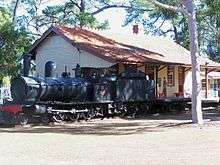 G118 at the Kalamunda Historical Village on the site of Kalamunda station | |
| Overview | |
| System | Western Australian Government Railways |
| Status | Dismantled |
| Termini |
Midland Junction Karragullen |
| Operation | |
| Opened | July 1891 |
| Closed | 22 July 1949 |
| Technical | |
| Line length | 35 kilometres |
| Track gauge | 1,067 mm (3 ft 6 in) |
The Upper Darling Range Railway (also known as the Upper Darling Range Branch) was a branch railway from Midland Junction, Western Australia, that rose up the southern side of the Helena Valley and on to the Darling Scarp via the Kalamunda Zig Zag. At the time of construction it was the only section of railway in Western Australia to have had a zig zag formation.
History
Completed in July 1891, the Upper Darling Range Railway line was built by the Canning Jarrah Timber Company to supply railway sleepers to Perth's growing railway system. It ran from Midland Junction railway station through to the Darling Ranges and up into Kalamunda. It was later extended to Canning Mills and in 1912 to Karragullen.[1] From Pickering Brook, a line branched off to Bartons Mill.[2][3]
On 1 July 1903, the line was taken over by the Western Australian Government Railways and became known as the Upper Darling Range Branch. The last service ran on 22 July 1949 with the line formally closed with the passing of the Railways (Upper Darling Range) Discontinuance Act in 1950 and dismantled in 1952.[2][3][4][5]
| Upper Darling Range Railway | ||||||||||||||||||||||||||||||||||||||||||||||||||||||||||||||||||||||||||||||||||||||||||||||||||||||||||||||||||||||||||||||||||||||||||||||||||||||||||||||||||
|---|---|---|---|---|---|---|---|---|---|---|---|---|---|---|---|---|---|---|---|---|---|---|---|---|---|---|---|---|---|---|---|---|---|---|---|---|---|---|---|---|---|---|---|---|---|---|---|---|---|---|---|---|---|---|---|---|---|---|---|---|---|---|---|---|---|---|---|---|---|---|---|---|---|---|---|---|---|---|---|---|---|---|---|---|---|---|---|---|---|---|---|---|---|---|---|---|---|---|---|---|---|---|---|---|---|---|---|---|---|---|---|---|---|---|---|---|---|---|---|---|---|---|---|---|---|---|---|---|---|---|---|---|---|---|---|---|---|---|---|---|---|---|---|---|---|---|---|---|---|---|---|---|---|---|---|---|---|---|---|---|---|---|
| ||||||||||||||||||||||||||||||||||||||||||||||||||||||||||||||||||||||||||||||||||||||||||||||||||||||||||||||||||||||||||||||||||||||||||||||||||||||||||||||||||
Stopping places
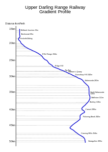
Named stopping places and locations on the line included:[6]
| Name | Previous name(s) | Distance from Perth | Height above sea level | ||
|---|---|---|---|---|---|
| Midland Junction station | Helena Vale | 15 km | 9.3 mi | 15 m | 49 ft |
| Bushmead (now under Roe Highway) | Waterhall | 17 km | 11 mi | 26 m | 85 ft |
| Rifle Range | 23 km | 14 mi | 104 m | 341 ft | |
| Poison Gully Creek (scene of 1904 crash) | |||||
| Number 1 Points Ridge Hill (lower section of Zig Zag) | 27 km | 17 mi | |||
| Number 2 Points Statham's Quarry | Perth City Council siding from 1920 | 28 km | 17 mi | ||
| Number 3 Points | |||||
| Number 4 Points (upper section of Zig Zag) | Possibly known as The Knoll | ||||
| Gooseberry Hill | 30 km | 19 mi | 242 m | 794 ft | |
| Kalamunda | Stirk's Landing | 32 km | 20 mi | 242 m | 794 ft |
| South Kalamunda | Guppy's Siding | 35 km | 22 mi | 283 m | 928 ft |
| Walliston | Wallis's Crossing | 37 km | 23 mi | 311 m | 1,020 ft |
| Bickley | (named Heidelberg between 1904 and 1915) | 38 km | 24 mi | 318 m | 1,043 ft |
| Carmel | Green's Landing | 40 km | 25 mi | 286 m | 938 ft |
| Pickering Brook | Pickering Junction | 42 km | 26 mi | 282 m | 925 ft |
| Canning Mills | Canning Timber Station | 48 km | 30 mi | 254 m | 833 ft |
| Karragullen | 50 km | 31 mi | 300 m | 980 ft | |
References
- ↑ Upper Darling Range Extension Act 1911 Government of Western Australia 9 January 1912
- 1 2 Bromby, Robyn (1988). Australian Rail Annual 1988. Sutherland: Sherbourne Sutherland Publishing. pp. 115–120. ISBN 1 86275 004 1.
- 1 2 History of the Railway Pickering Brook Heritage Group
- ↑ Railways (Upper Darling Range) Discontinuance Act Government of Western Australia 29 December 1950
- ↑ Complaints About New Railway Bill The West Australian 1 December 1950 page 4
- ↑ Part of this table is sourced from:- Slee, John (1979) Cala Munnda pp.55-56
Further reading
- Gunzburg, Adrian (1967) Upper Darling Range Railway: WAGR held at Battye Library
- Price, Eric T. (1983) The Canning jarrah line, 1891-1903 Western Australia : E.T. Price
- Slee, John. (1979) Cala Munnda : a home in the forest : a history of Kalamunda Kalamunda, W.A. : Shire of Kalamunda. ISBN 0-9595831-0-6
- Steele, Ken.(1993) Zig Zag to Kalamunda : the story of the Upper Darling Range Railway Lesmurdie, W.A.: Drillmark Publications Division. ISBN 0-646-16323-X
- Watson, Lindsay (1995)The Railway History Of Midland Junction : Commemorating The Centenary Of Midland Junction, 1895-1995 Swan View, W.A : L & S Drafting in association with the Shire of Swan and the Western Australian Light Railway Preservation Association.
- Webb, E.G. (Eric Godfrey) & Kalamunda and Districts Historical Society (1996). Rails in the hills : a history of the railway from Midland to Karragullen, 1891-1949 Kalamund & Districts Historical Society, Kalamunda, W.A