Washington State Route 243
| ||||
|---|---|---|---|---|
|
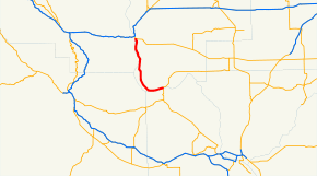
SR 243 highlighted in red. | ||||
| Route information | ||||
| Auxiliary route of SR 24 | ||||
| Defined by RCW 47.17.465 | ||||
| Maintained by WSDOT | ||||
| Length: | 28.26 mi[1] (45.48 km) | |||
| Existed: | 1964[2] – present | |||
| Major junctions | ||||
| South end: |
| |||
| East end: |
| |||
| Highway system | ||||
| ||||
State Route 243 (SR 243) is a 28.26-mile (45.48 km) long state highway in the U.S. state of Washington, located entirely within Grant County and serving Desert Aire, Mattawa, Beverly and Vantage. The roadway, which roughly parallels the Columbia River, begins at SR 24 southwest of Desert Aire and continues north past the Priest Rapids Dam and Wanapum Dam to SR 26 south of Vantage. The road was established originally as a branch of Secondary State Highway 7C (SSH 7C) in 1957. In 1964, the SSH 7C branch became SR 243 even though the road between SR 24 and Beverly was not complete until 1981.
Route description
State Route 243 (SR 243) begins at an intersection with SR 24 southwest of Desert Aire and north of the Hanford Site and Vernita Bridge. From the terminus, the highway travels west and northwest along the Columbia River to the Priest Rapids Dam and Desert Aire to turn north past Mattawa into Beverly. In Beverly, where it crosses railroad tracks formerly belonging to the Chicago, Milwaukee, St. Paul and Pacific Railroad west of the Beverly Railroad Bridge.[1][3] After leaving Beverly, the roadway passes the Wanapum Dam to end at SR 26,[4][5] south of its interchange with Interstate 90 (I-90).[6] The busiest segment of SR 243 in 2007 was between SR 24 and Desert Aire, with a daily average of 4,600;[7] in 1970, the same area was the busiest segment with a daily average of 950.[8]
History
The first state-maintained highway to take the current route of SR 243 was a branch of Secondary State Highway 7C (SSH 7C), established in 1957; the branch ran from SSH 11A to SSH 7C.[9] By 1963, only the Beverly–SSH 7C portion of the highway was completed;[3] the 1964 highway renumbering renumbered SSH 7C to SR 26, the branch to SR 243 and SSH 11A to SR 24.[2][10] SR 24, SR 26 and SR 243 were all partially incomplete until 1981.[3][11]
Major intersections
The entire route is in Grant County.
| Location | mi[1] | km | Destinations | Notes | |
|---|---|---|---|---|---|
| | 0.00 | 0.00 | |||
| | 28.26 | 45.48 | |||
| 1.000 mi = 1.609 km; 1.000 km = 0.621 mi | |||||
References
- 1 2 3 Washington State Department of Transportation (2006). "State Highway Log: Planning Report, SR 2 to SR 971" (PDF). Retrieved June 30, 2009.
- 1 2 Washington State Legislature. "RCW 47.17.465: State route No. 243". Retrieved June 30, 2009.
- 1 2 3 United States Geological Survey (1963). Walla Walla, 1963 (Map). 1:250,000. University of Texas at Austin. Retrieved June 30, 2009.
- ↑ Google (June 30, 2009). "State Route 243" (Map). Google Maps. Google. Retrieved June 30, 2009.
- ↑ Washington State Highways, 2008–2009 (PDF) (Map) (2008–09 ed.). 1:842,000. Cartography by United States Geological Survey. Washington State Department of Transportation. 2008–09. § F6. Retrieved June 30, 2009. Check date values in:
|date=(help) - ↑ Washington State Department of Transportation (January 27, 2006). "SR 90 – Exit 147; Junction SR 26" (PDF). Retrieved June 30, 2009.
- ↑ Washington State Department of Transportation (2007). "2007 Annual Traffic Report" (PDF). Retrieved June 30, 2009.
- ↑ Washington State Highway Commission, Department of Highways (1970). "Annual Traffic Report, 1970" (PDF). Washington State Department of Transportation. pp. 160–161. Retrieved June 30, 2009.
- ↑ Washington State Legislature (1957). "Chapter 172". Session Laws of the State of Washington. Session Laws of the State of Washington (1957 ed.). Olympia, Washington. Retrieved June 30, 2009.
- ↑ C. G. Prahl (December 1, 1965). "Identification of State Highways" (PDF). Washington State Highway Commission, Department of Highways. Retrieved June 30, 2009.
- ↑ United States Geological Survey (1981). Walla Walla, 1981 (Map). 1:250,000. University of Texas at Austin. Retrieved June 30, 2009.

