Waskahegan Trail

The Waskahegan Trail is a walking/hiking trail that runs through and around Edmonton, Alberta, Canada. It is 309 km and runs through a mix of public and private land. Landowners are paid nothing. Their permission is given on the understanding that it can be withdrawn at any time for any reason. The trail is managed by a volunteer board, the Waskahegan Trail Association (WTA).
History
The beginnings of the trail started in 1967 with Fred Dorward, the trail's founder, pitching the idea to the Oil Capital Kiwanis group who provided funding and support. Other people and organizations involved at this time were the Edmonton Regional Planning Commission, Edmonton Parks and Recreation, the Alberta Department of Youth, Alberta Public Works, the Canadian Hostelling Association, the Scouts Association, Alberta Travel, Elk Island National Park and Grant MacEwan.
The trail was named in a contest in 1967 by D.B. Remington. Waskaheegan is Plains Cree for "house", in reference to the nearby Fort Edmonton trading post. At the same time in 1967, the Regional Trails Committee was formed to promote the Trail in the Edmonton Journal and set up the group's bylaws. WTA was 'born' at 7:40 pm, March 20, 1969 at a meetings of the Regional Trails Committee. Work in earnest began in 1973 with 100 kilometres (62 mi) of trail being built and the first guide book published.
Current route


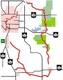
Although the trail is more or less circular in shape, its starting point is in northeast Edmonton at the intersection of the river and 144th Avenue. From this point it runs southwest to the Whitemud and Blackmud Creeks, ending at Ellerslie Road, the first gap. This gap ends at Saunders Lake (directly east of the Edmonton International Airport), south to Coal Lake in the Wetaskiwin area, then east along the Battle River from Gwynne to Camrose. North of Camrose is the second gap, after which the trail continues north from Miquelon Lake Provincial Park through Ministik Lake Bird Sanctuary, the Hastings Lake area, and the Cooking Lake - Blackfoot Recreation Area to Elk Island National Park. It then continues west along Ross Creek to Fort Saskatchewan. The third and final gap is between Fort Saskatchewan and the starting point in Edmonton.
Trees and tall shrubs in the Waskahegan area
| Conifers | |||||
| Deciduous trees |
|
Mammals of the Waskahegan area
| Shrews | |||||
| Hares | |||||
| Bats | |||||
| Rodents |
| ||||
| Carnivores |
| ||||
| Ungulates |
References
- WTA website
- The Waskahegan Trail Guide Book, 2009 ed.