Weston-sub-Edge railway station
| Weston-sub-Edge | |
|---|---|
|
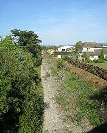
Station site in 2005. | |
| Location | |
| Place | Weston-Sub-Edge |
| Area | Cotswold |
| Grid reference | SP116417 |
| Operations | |
| Original company | Great Western Railway |
| Post-grouping |
Great Western Railway Western Region of British Railways |
| Platforms | 2 |
| History | |
| 1 August 1904 | Opened as Bretforton & Weston-sub-Edge |
| 1 May 1907 | Renamed Weston-sub-Edge |
| 25 September 1950 | Closed to goods |
| 7 March 1960 | Closed to passengers |
| Disused railway stations in the United Kingdom | |
|
Closed railway stations in Britain A B C D–F G H–J K–L M–O P–R S T–V W–Z | |
|
| |

Weston-sub-Edge railway station is a disused station on the Honeybourne Line from Stratford-upon-Avon to Cheltenham which served the village of Weston-Sub-Edge in Gloucestershire between 1904 and 1960.
History
On 9 July 1859, the Oxford, Worcester and Wolverhampton Railway opened a line from Stratford-upon-Avon to Honeybourne.[1][2] The OW&W became the West Midland Railway in 1860 and was acquired by Great Western Railway in 1883 with a view to combining it with the Birmingham to Stratford Line to create a high-speed route from the Midlands to the South West.[3][4] The GWR obtained authorisation in 1899 for the construction of a double-track line between Honeybourne and Cheltenham and this was completed in stages by 1908.[5]
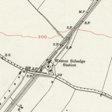
As the first station on the new line, Weston-sub-Edge was opened on 1 August 1904.[6] Initially known as Bretforton and Weston-sub-Edge until 1 May 1907,[6] the station was a mile from Weston-Sub-Edge and 3 miles (4.8 km) from Bretforton.[7][8] It was located immediately to the north of the bridge carrying the B4035 road over the line from which a footpath led down to the 'Up' platform.[7] The 400-foot (120 m) platforms were equipped with the usual lamps, nameboards and fencing.[7] A 27-lever signal box was provided on the 'Up' side to the south of the platform and it controlled a siding capable of holding 15 wagons, as well as access to the small goods yard, equipped with a small goods shed, 6-ton crane and weighbridge, which handled mainly agricultural and, in particular, meat for use in the production of animal glue.[9][10][11] Average tonnage handled was around 3,000 tons a year in the 1920s, which began to fall off in the 1930s before picking up again in the Second World War when it reached a peak of 15,366 in 1941.[12] The principal generator of wartime traffic was the airfield established to the north-west of the station behind the signalbox; the airfield was known as Honeybourne and its personnel used the station.[13]
A stationmaster's house was located adjacent to the goods yard on the 'Down' side, although Weston-sub-Edge only had a stationmaster until 1932 after which the station came under the control of the Broadway stationmaster.[14] Adjoining the house was accommodation for other staff: a ganger and platelayer.[13] The goods yard closed on 25 September 1950, followed soon after by the signalbox on 8 October 1950.[7] From this point, the station became a large unstaffed halt until its closure on 7 March 1960 with the withdrawal of local passenger trains on the line.[15][13][16][6]
| Preceding station | Disused railways | Following station | ||
|---|---|---|---|---|
| Honeybourne Line closed, station open |
Great Western Railway Honeybourne Line |
Willersey Halt Line and station closed | ||
| |
||||
| Honeybourne Line closed, station open |
Gloucestershire Warwickshire Railway | Broadway Line and station closed | ||
Present and future
Little trace remains of Weston-sub-Edge station.[12] The 'Up' platform building was dismantled and re-erected at Carrog on the Llangollen Railway whilst the trackbed and road bridge remain as part of a footpath and cycleway.[17][12]
The Gloucestershire Warwickshire Railway aims to reopen the line through Weston-sub-Edge as part of an extension of its line to Honeybourne.[18] This might even include rebuilding and reopening the station site itself, once fundraising and support from locals nearby could begin.
References
- ↑ Yorke 2009, p. 82.
- ↑ Maggs & Nicholson 1985, p. 7.
- ↑ Kingscott 2009, p. 97.
- ↑ Oppitz 2004, p. 33.
- ↑ Oppitz 2004, pp. 33-35.
- 1 2 3 Quick 2009, p. 407.
- 1 2 3 4 Baker 1994, p. 81.
- ↑ Yorke 2009, pp. 85-85.
- ↑ Baker 1994, p. 81-81.
- ↑ Maggs & Nicholson 1985, p. 36.
- ↑ Mitchell & Smith 2005, fig. 40.
- 1 2 3 Mitchell & Smith 2005, fig. 42.
- 1 2 3 Baker 1994, p. 82.
- ↑ Baker 1994, pp. 80-81.
- ↑ Maggs & Nicholson 1985, pp. 36, 60.
- ↑ Mitchell & Smith 2005, fig. 41.
- ↑ Siviter 2003, p. 80.
- ↑ Crowder, Ian. "A Perfect Stop. At Toddington. And Broadway. And Honeybourne?". Gloucestershire Warwickshire Railway. Retrieved 2014-10-30.
Sources
- Baker, Audie (1994). The Stratford on Avon to Cheltenham Railway. Grasscroft, Oldham: Irwell Press. ISBN 978-1-871608-62-5.
- Butt, R.V.J. (1995). The Directory of Railway Stations. Yeovil: Patrick Stephens Ltd. ISBN 1-85260-508-1. R508.
- Clinker, C.R. (October 1978). Clinker's Register of Closed Passenger Stations and Goods Depots in England, Scotland and Wales 1830-1977. Bristol: Avon-Anglia Publications & Services. ISBN 0-905466-19-5.
- Kingscott, Geoffrey (2009). Lost Railways of Warwickshire. Newbury, Berkshire: Countryside Books. ISBN 978-1-84674-174-6.
- Maggs, Colin G.; Nicholson, Peter (1985). The Honeybourne Line: The continuing story of the Cheltenham to Honeybourne and Stratford upon Avon Railway. Cheltenham, Glos.: Line One Publishing. ISBN 978-0-907036-12-8.
- Mitchell, Victor E.; Smith, Keith (August 2005) [1998]. Stratford upon Avon to Cheltenham. Country Railway Routes. Midhurst: Middleton Press. ISBN 1-901706-25-7.
- Oppitz, Leslie (2004) [2002]. Lost Railways of Herefordshire & Worcestershire. Newbury, Berkshire: Countryside Books. ISBN 978-1-85306-754-9.
- Quick, Michael (2009) [2001]. Railway passenger stations in Great Britain: a chronology (4th ed.). Oxford: Railway and Canal Historical Society. ISBN 978-0-901461-57-5. OCLC 612226077.
- Siviter, Roger (2003) [1997]. The Gloucestershire Warwickshire Railway. Kettering, Northants: Past & Present Publishing. ISBN 1-85895-208-5.
- Yorke, Stan (2009). Lost Railways of Gloucestershire. Newbury, Berkshire: Countryside Books. ISBN 978-1-84674-163-0.
Coordinates: 52°04′25″N 1°49′55″W / 52.07358°N 1.83181°W
