Whangaparaoa Peninsula


Whangaparāoa Peninsula is a suburban area about 25 km north of Auckland in New Zealand. It had 30,672 residents in 2013,[1] many of them in the eponymous town of Whangaparāoa on its southern side.[2] It is part of the Hibiscus Coast.
Geography
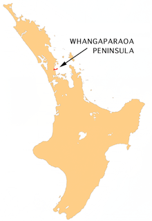
The peninsula is in the northern North Island, close to the base of the North Auckland Peninsula. Whangaparāoa is Māori for "Bay of Whales", and pods of orca and dolphin are regularly spotted in the waters off the peninsula. The peninsula is mostly urbanised and is in the Northern Auckland Zone of the Auckland urban area, as defined by Statistics New Zealand. Since 2010, it has been part of the Albany Ward and the Hibiscus and Bays Local Board of the Auckland Region.
Until relatively recently a sparsely inhabited rural area, it is now populated with a large retired community, along with young families and couples, the city lying 25 kilometres to the south. The suburb of Gulf Harbour, four kilometres from the tip of the peninsula where the Gulf Harbour Country Club is located is one of the last suburbs to be developed and is quickly increasing in population.[3]
Auckland's Northern Motorway (State Highway One) was extended to Orewa at the end of the 1990s, reducing journey time into the city and making it more popular for commuters. The proposed Penlink road (including a bridge over the Weiti River from Stanmore Bay to Stillwater) would provide a quicker route between the peninsula and central Auckland.[4]
The peninsula stretches east for 11 kilometres into the Hauraki Gulf, to the north of East Coast Bays. Tiritiri Matangi Island is three kilometres off its eastern tip. The town of Whangaparāoa is on the southwestern shore, and is regarded as the start of the Hibiscus Coast.
Communities include Red Beach, Stanmore Bay, Manly, Tindalls Bay, Army Bay, Gulf Harbour, Matakatia Bay, and Arkles Bay. At the end of the peninsula is Shakespear Regional Park. The New Zealand Defence Force owns part of this area, which has been used as a resettlement camp for refugees.
In the past twenty years a township has developed on the high land above Stanmore Bay and at the proposed Penlink intersection, including a shopping centre, a movie theatre, a bowling alley, a library and community centre. While the area was once relatively remote, the shopping facilities, including two supermarkets, have made living on the extremities of the peninsula more convenient, especially as the central city is now approximately 45 minutes away during off-peak periods.
Association football
The peninsula is home to football (soccer) club Hibiscus Coast AFC, which competes in the Lotto Sport Italia NRFL Division 2.
Transportation
Hibiscus Coast is served by Auckland Transport bus routes operated by AT Metro to destinations including Hibiscus Station [5] and central Auckland. Ferries operated by 360 Discovery run between Gulf Harbour and central Auckland daily, and to Tiritiri Matangi.
Education
Whangaparāoa College is the main college. It was formed from Hibiscus Coast Intermediate School in 2005, and first had all years 7 to 13 attending in 2009.
Other schools:
- Wentworth College and Primary[6](Gulf Harbour)
- Whangaparāoa Primary
- Stanmore Bay Primary
- Gulf Harbour School
- Red Beach Primary
- Orewa College
- KingsWay School
See also
References
- ↑ http://www.stats.govt.nz/StatsMaps/Home/People%20and%20households/2013-census-quickstats-about-a-place-map.aspx
- ↑ "Auckland Places - Whangaparāoa Peninsula". Te Ara Encyclopedia of New Zealand. Government of New Zealand. Retrieved 3 March 2010.
- ↑ http://www.gulfharbourcountryclub.co.nz/layouts/terraces2/Template.aspx?page=splash
- ↑ https://at.govt.nz/projects-roadworks/penlink/
- ↑ https://at.govt.nz/media/1232844/hibiscus-coast-new-network-oct-2015-map-v2.pdf
- ↑ http://www.wentworth.school.nz/
Coordinates: 36°38′S 174°46′E / 36.633°S 174.767°E