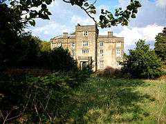
Winstanley, Greater Manchester
| Winstanley | |
 Winstanley Hall |
|
 Winstanley |
|
| Population | 11,264 (2011 Census) |
|---|---|
| OS grid reference | SD531051 |
| Metropolitan borough | Wigan |
| Metropolitan county | Greater Manchester |
| Region | North West |
| Country | England |
| Sovereign state | United Kingdom |
| Post town | WIGAN |
| Postcode district | WN3 |
| Dialling code | 01942 |
| Police | Greater Manchester |
| Fire | Greater Manchester |
| Ambulance | North West |
| EU Parliament | North West England |
| UK Parliament | Makerfield |
|
|
Coordinates: 53°31′22″N 2°40′38″W / 53.5229°N 2.6772°W
Winstanley is an area of the Metropolitan Borough of Wigan, in Greater Manchester, England.[1] Historically in Lancashire, the area is now a residential suburb, and has a total population of 15,849, reducing at the 2011 census to 11,264.[2]
Transport
Train services to Wigan, Manchester and Kirkby are available at the nearby Pemberton railway station. The main road in the Winstanley area is the A571 (St.Helens to Wigan). Nearby is the A49, which gives access to the M6 motorway.
Local schools
- Highfield St. Matthew's CofE Primary School
- St. Aidan's Catholic Primary School, Wigan
- Winstanley Community Primary School
- Winstanley College
- Hawkley Hall High School
Adjacent places
- Billinge 'Chapel End'
- Billinge 'Higher End'
- Orrell
- Pemberton
See also
References
- ↑ "Greater Manchester Gazetteer". Greater Manchester County Record Office. Place Names T to W. Archived from the original on 18 July 2011. Retrieved 17 June 2008.
- ↑ "Wigan ward population 2011". Retrieved 11 January 2016.
External links
This article is issued from Wikipedia - version of the 1/11/2016. The text is available under the Creative Commons Attribution/Share Alike but additional terms may apply for the media files.