Young, Saskatchewan
| Young | |
|---|---|
| Village | |
|
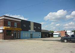
Main Street | |
 Young  Young Location of Young in Saskatchewan | |
| Coordinates: 51°28′N 105°26′W / 51.46°N 105.44°W | |
| Country | Canada |
| Province | Saskatchewan |
| Region | Saskatchewan |
| Founded | 1908 |
| Post Office Established | 1909-04-01 |
| Village Incorporated | June 7, 1910 |
| Government | |
| • Mayor | Brian Rowan |
| • Governing body | Young Village Council |
| Area | |
| • Land | 2.51 km2 (0.97 sq mi) |
| Population (2011)[1] | |
| • Total | 239 |
| • Density | 95.2/km2 (247/sq mi) |
| Time zone | CST |
| Postal code | S0K 4Y0 |
| Area code(s) | 306 |
| Highways | Highway 2 |
| Website | Official Site |
| [2][3] | |
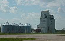
Young is a village in Saskatchewan. The economy is dominated by local agriculture and the nearby Mosaic Potash mine.[4]
History
Young came into being with the coming of the Grand Trunk Pacific Railroad and at one time hoped to be the hub of four railroads. It was incorporated into a town in 1910, named for F.G. Young, land agent. Wide streets were laid for a growing town with sights on becoming a city. Business flourished: stores, hotel, billiard hall, barber shop, bank, doctor, drug store, no less than three lumber yards, livery barns, blacksmith shop, three churches and a school.

A train engineer took note of the rock formations near town. He came back to develop a huge limestone kiln that produced 1000 bushels of lime a day. Concrete formed the base of this structure that stood 53 feet high with a trestle 200 feet long. The remains can still be seen at the north-west end of 2nd Avenue, just beyond the Senior housing.
The far-sighted and ambitious pioneers who started the town may have had their dreams toned down somewhat as Young did not become the hub of the railroads and the large town and city never came its way. The present residents still have some of that enthusiasm flowing through their veins. For a village of less than 300 people, it has a store, service station, post office, Credit Union, Insurance agent, restaurant, two churches, private caterers and a school.
On the social side, the 3 sheet curling rink with artificial ice and hockey arena are the centre of activity in the winter. The swimming pool, golf course, ball diamonds and the ever improving playground are the places to be in the summer. Its school has a shop, home economics, computer room, photography, art program and gymnasium.[5]
A fire destroyed the village's oldest building, a former hotel, bar and popular meeting place for residents. The blaze at the Young Hotel started shortly before 3 a.m. on November 12, 2011. The hotel was built in 1910.[6]
Demographics
| Canada census – Young, Saskatchewan community profile | |||
|---|---|---|---|
| 2011 | 2006 | 2001 | |
| Population: | 239 (-9.1% from 2006) | 263 (-12.0% from 2001) | 299 (-6.6% from 1996) |
| Land area: | 2.51 km2 (0.97 sq mi) | 2.51 km2 (0.97 sq mi) | 2.51 km2 (0.97 sq mi) |
| Population density: | 95.2/km2 (247/sq mi) | 104.8/km2 (271/sq mi) | 119.2/km2 (309/sq mi) |
| Median age: | 53.8 (M: 53.7, F: 53.9) | 49.9 (M: 49.8, F: 50.0) | 43.8 (M: 44.4, F: 43.1) |
| Total private dwellings: | 150 | 150 | 152 |
| Median household income: | $n/a | $28,236 | $25,286 |
| References: 2011[7] 2006[8] 2001[9] | |||
References
- ↑ "2011 Community Profiles". Statistics Canada. Government of Canada. Retrieved 2014-08-21.
- ↑ National Archives, Archivia Net. "Post Offices and Postmasters". Retrieved 2014-08-21.
- ↑ Government of Saskatchewan, MRD Home. "Municipal Directory System". Archived from the original on January 15, 2016. Retrieved 2014-08-21.
- ↑ "Economy of Young". Village of Young. Retrieved 2011-03-06.
- ↑ "History of Young". Village of Young. Retrieved 2011-03-06.
- ↑ "Young's century-old hotel building destroyed". CBC News. Retrieved 2013-02-09.
- ↑ "2011 Community Profiles". Canada 2011 Census. Statistics Canada. July 5, 2013. Retrieved 2013-02-03.
- ↑ "2006 Community Profiles". Canada 2006 Census. Statistics Canada. March 30, 2011. Retrieved 2011-03-06.
- ↑ "2001 Community Profiles". Canada 2001 Census. Statistics Canada. February 17, 2012. Retrieved 2011-03-06.
External links
| Wikimedia Commons has media related to Young, Saskatchewan. |
| North: Viscount | ||
| West: Allan | Young | East: Watrous |
Coordinates: 51°45′54″N 105°44′39″W / 51.76500°N 105.74417°W
