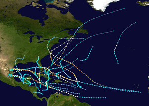
1933 Florida–Mexico hurricane
| Category 1 hurricane (SSHWS/NWS) | |
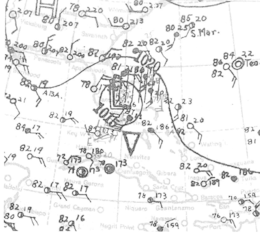 | |
| Formed | July 24, 1933 |
|---|---|
| Dissipated | August 5, 1933 |
| Highest winds |
1-minute sustained: 90 mph (150 km/h) |
| Lowest pressure | 975 mbar (hPa); 28.79 inHg |
| Fatalities | 39 total |
| Damage | $3 million (1933 USD) |
| Areas affected | Leeward Islands, Turks and Caicos Islands, The Bahamas, Florida, Texas, Mexico |
| Part of the 1933 Atlantic hurricane season | |
The 1933 Florida–Mexico hurricane was the first of two Atlantic hurricanes to strike the Treasure Coast region of Florida in the very active 1933 Atlantic hurricane season. It was one of two storms that year to inflict hurricane-force winds over South Texas, causing significant damage there; the other occurred in early September. The fifth tropical cyclone of the year, it formed east of the Lesser Antilles on July 24, rapidly strengthening as it moved west-northwest. As it passed over the islands, it attained hurricane status on July 26, producing heavy rains and killing at least six people. Over the next three days, it moved north of the Caribbean, paralleling the Turks and Caicos Islands and the Bahamas. The storm produced extensive damage and at least one drowning as it crossed the Bahamas. On July 29, the cyclone came under the influence of changing steering currents in the atmosphere, which forced the storm into Florida near Hobe Sound a day later. A minimal hurricane at landfall, it caused negligible wind damage as it crossed Florida, but generated heavy rains along its path, causing locally severe flooding. The storm turned west, weakened to below hurricane status, and later exited the state north of Charlotte Harbor on July 31.
Once over the eastern Gulf of Mexico, the storm shifted its course to the west-southwest and gradually recovered its intensity. The path of the storm brought it close to the mouth of the Rio Grande in early August. Few ships encountered the small storm as it regained hurricane status on August 4, just a day before striking northern Mexico with winds of 90 mph (145 km/h)—making it close to a modern-day Category 2 hurricane on the Saffir-Simpson hurricane wind scale. Striking close to the border between the United States and Mexico, the storm caused extensive damage in both countries. Winds damaged buildings and crops in Tamaulipas and the southern regions of Texas, with heavy losses to citrus production in the Rio Grande Valley. While only one person died in the United States, heavy rains led to catastrophic flooding that claimed at least 31 lives in northern Mexico; the worst-hit areas were in and near the city of Monterrey. While monetary losses in Mexico were unclear, the storm did at least $3,000,000 in damages in the United States, measured in contemporary U.S. dollars.
Historical context
The July storm was not the last to damage the Treasure Coast of Florida in 1933: a much stronger cyclone in September, with winds of 125 mph (200 km/h), extensively damaged the same area that the July storm affected. This storm overshadowed memories of the earlier hurricane, and would be remembered as among the worst on the Treasure Coast as late as the 1980s.[1][2] The occurrence of two hurricanes on the east coast of Florida in the same season is a relatively rare event in historical records, but not unprecedented: for instance, forensic research by weather historian David M. Ludlum suggests that two or more hurricanes in 1837 may have affected the region. Citing reports from William Reid in Law of Storms (1838), Ludlum noted that two hurricanes affected Central and Northeast Florida on August 1–2 and September 6, respectively, while other storms, potentially hurricanes, may have done so later in September. The September hurricane struck between St. Augustine and Jacksonville. Incidentally, the 1837 Atlantic hurricane season was apparently very active, like 1933; as in 2004, a record four hurricanes hit the state of Florida, including the infamous Racer's Storm in October.[3][4]
Meteorological history
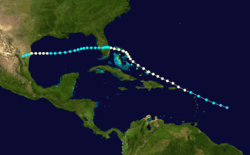
At 12:00 UTC on July 24, HURDAT initialized a tropical depression some 430 miles (690 km) east of Saint Lucia in the Windward Islands.[5] (This was at the time that another tropical system formed over 450 mi (725 km) east of Bermuda.) Prior to reanalysis in 2012, official records indicated formation at 12:00 UTC on July 25; however, examination of observations from ships and land stations revealed a closed low a day earlier.[6] Upon generation, the depression moved generally west-northwest, toward the eastern Caribbean, becoming a tropical storm at 00:00 UTC on July 25.[5] However, ships and weather stations did not observe gales until later that day, so the winds in HURDAT were interpolated, but based on available data, the storm strengthened steadily.[6] At 16:00 UTC, the British steamship Daytonian recorded a pressure of 1,012 mb (29.87 inHg), followed by peak winds of Force 9, about 45 mph (72 km/h), from the east.[7] Around that time, the island of Antigua also experienced gales and a pressure of 1,002 mb (29.59 inHg) as the storm made landfall with winds of 60 to 70 mph (95 to 110 km/h).[6] A barometer on Saba measured 983 mb (29.02 inHg), implying maximum sustained winds of 85 mph (140 km/h);[8] based on this, the storm was posthumously upgraded to hurricane status at 00:00 UTC on July 26, 12 hours earlier than once designated in HURDAT.[6]
As the storm neared Saint Thomas, the island experienced northeast winds of 60 mph (97 km/h).[9] On its west-northwest course, the storm—now equivalent to a Category 1 hurricane—missed Puerto Rico to its northeast.[5] On July 27, the cyclone brushed Grand Turk and the Caicos, producing winds visually estimated at 85 mph (137 km/h) on the former island, with a peripheral pressure of 995 mb (29.37 inHg).[9] The hurricane gradually bent to the northwest as it followed the arc of the eastern Bahamas.[5] After 15:00 UTC on July 28, the Norwegian steamship Noreg encountered southeast winds of 70 mph (110 km/h), yet pressures only dipped to 1,002 mb (29.58 inHg).[7] The storm struck Cat Island, Bahamas, around 18:00 UTC with winds of 80 mph (130 km/h); the next day, the storm made another landfall on the Abaco Islands with the same winds. During this time, the storm turned to the west-northwest, nearing the east coast of Florida;[5] this was likely due to a robust subtropical ridge in the area.[10]
Based on ship reports, the storm made its only landfall in the United States on Jupiter Island, between Port Salerno and Hobe Sound, Florida, around 16:00 UTC on July 30.[5] Some hours earlier, the American steamship El Almirante encountered hurricane-force winds—the only such instance at sea in the storm—concurrent with a pressure of 998 mb (29.46 inHg).[7][11] Another ship nearby made a reading of 992 mb (29.29 inHg) coincident with winds of 50 mph (80 km/h), hinting that it was taken inside the eye of the storm; calculations by researchers determined that the central pressure was 988 mb (29.18 inHg) at the time and at landfall in Florida.[6] While this supported winds of only tropical storm force (70 mph (110 km/h)), the storm had a small radius of outermost closed isobar embedded in a ridge of high pressure, so winds in Florida were deemed to be 75 mph (120 km/h), affirming earlier reports that listed the storm as a hurricane at landfall.[6] After landfall, the storm weakened to a tropical storm and moved slowly westward across the south-central peninsula, passing over the northern end of Lake Okeechobee early on July 31. The center of the compact tropical cyclone then passed slightly north of Punta Gorda and reached the Gulf of Mexico, between Venice and Englewood, with winds of 45 mph (75 km/h).[5]
From this point, few ships were near the center of the storm with which to accurately discern its location and intensity, though data on August 1–2 confirmed a weaker cyclone than earlier.[9] At 00:00 UTC on August 1, the storm began a persistent west-southwest motion that continued for the rest of its life cycle. A few ships on August 1–3 noted modest gales of 40 mph (64 km/h), with the lowest pressure on weather maps being 1,004 mb (29.65 inHg) at 12:00 UTC on August 3.[6] Based on this pressure, reanalysis inferred that the storm began gradually restrengthening a day earlier, reaching 65 mph (100 km/h) at the time of the reading. Although the storm regained hurricane status at 00:00 UTC on August 4, due to the sparsity of ship data, weather forecasters at the time assumed the storm only contained gale-force winds.[9] For a day, the storm briefly angled to the west as it neared the Mexico–United States border, reaching its final and strongest peak of 90 mph (150 km/h) late on August 4.[5] Anemometers in Brownsville, Texas, verified a landfall near Playa Lauro Villar, Tamaulipas, just south of the Rio Grande, near 01:00 UTC on August 5. Based on the data, scientists ascertained a radius of maximum wind of about 30 mi (45 km) as the eye made landfall.[6] Barometers in Brownsville showed pressures of 981 to 982 mb (28.98 to 29 inHg), attesting a central pressure of 975 mb (28.79 inHg) in the eye.[6][8][12] Now hooking west-southwest, the storm quickly atrophied as it moved inland and vanished over easternmost Nuevo León by 18:00 UTC on August 5.[5]
Preparations
Although the storm affected several Caribbean islands, the Turks and Caicos, and the Bahamas, preparations there, if any, were unclear.[9] Residents across Puerto Rico boarded up windows and secured roofs in anticipation of damaging winds.[13] Governor Robert Hayes Gore placed the Hurricane Relief Organization and Red Cross on standby.[14] As the storm neared Florida, the United States Weather Bureau—later the National Weather Service—posted storm warnings between Miami and Titusville. These were later extended to include the west coast of the state from Punta Rassa to Tarpon Springs.[9] At the time, forecasters were unaware that the storm was of hurricane status; this unawareness extended to the storm's passage over the Gulf of Mexico. Forecasters only issued storm warnings for part of the Texas coast, including the cities of Brownsville and Freeport.[9]
Upon news of the storm, businesses in West Palm Beach boarded up vulnerable, expensive plate glass windows.[15] Fearing flooding, authorities were empowered by Florida governor David Sholtz to evacuate over 4,200–5,000 residents, most of whom were black farm workers, from low-lying areas around Lake Okeechobee to elevated locations. Most of the evacuees left by train, prompted by fears of washouts on the track beds.[16][17] A day before the storm, the lake level reached 17 feet (5.2 m), heightening officials' concerns about flooding and spurring the evacuations. Several railway companies lent free transport to their passengers, and trains were conveniently stationed around the lake.[16] The evacuations took place in the communities of Belle Glade, Pahokee, Canal Point, Okeechobee, and Clewiston. Relief organizations and local mayors distributed milk, biscuits, and coffee to evacuees.[18] On the west coast of the state, some residents covered their windows, but many others did not, anticipating little damage from the weak storm. Citizens received radio updates from the Weather Bureau, which gave the position and movement of the storm.[19] Some beachfront residents, such as in Sarasota, left their homes for safety, while boaters secured their vessels.[20][21]
In Texas, the Weather Bureau notified people early enough to allow mass evacuations: most coastal residents and camping visitors evacuated the vulnerable islands as the storm neared. Between 60–70% of Port Isabel's 500 residents left before the storm, with the remainder sheltering in a sturdy brick store on the highest land available.[22]
Impact
Throughout the hurricane's path from the Caribbean, to Florida, and finally into Texas and Mexico, 39 people were killed. Thirty-one deaths occurred in Mexico,[23] six in Saint Kitts,[24] and one in both the Bahamas and Texas.[25][12] Although figures from Mexico were unavailable, total losses from the storm in the United States reached about $3 million, inclusive of Florida and Texas, though figures for the latter state varied from $500,000 to $1.75 million, according to various sources.[26][27][28][29]
Caribbean
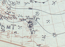
As it passed over the Lesser Antilles, the storm caused at least six deaths on the island of Saint Kitts—then known as Saint Christopher Island[30]—and the Virgin Islands reported torrential rains,[24] though no damage was reported. The barometer dipped to 1,005 mb (29.69 inHg) as the storm bypassed the islands to the south.[30] Crops and farm fencing on Saint Croix sustained some damage, though overall effects were limited. Coincidentally, the storm arrived the day after Hurricane Supplication Day, a local tradition marking the opening of hurricane season on the fourth Monday in July.[31] In the Bahamas, winds of 84 mph (135 km/h) swept the Abaco Islands early on July 29, but caused only minimal damage there.[32] Other reports indicated more severe damage elsewhere in the islands, including across the Turks and Caicos Islands,[33] and one death from drowning.[25] The American schooner Adams, anchored off Grand Turk, was dragged out to sea by the hurricane's waves.[33]
Florida
Wind damage was generally minimal as the small hurricane crossed Florida, except to citrus crops and snapped vegetation in some areas. According to a survey by local fire officials, the calm eye was observed from Hobe Sound to the edge of Stuart, during which passage "hardly a needle in pine trees along the side of the road could be seen moving."[34] Peak winds estimated or registered at 60 to 70 mph (97 to 113 km/h) affected the coast between Stuart and Fort Pierce.[26][35] The winds downed several telegraph poles and destroyed a structure at Stuart, but otherwise little damage resulted.[34] Initial reports from Fort Pierce signaled no uprooted trees.[20] Farther south, apart from a snapped coconut palm, the town of Palm Beach evinced little damage to foliage.[36] In Fort Pierce, heavier losses to grapefruit were accounted at about 25%, especially in exposed groves, and some trees suffered total loss of fruit. Shrubs and roofs in the city were damaged as well, but power and water services were quickly revived as the worst of the storm passed.[37] Final losses to citrus in the Indian River region were tallied at 10–20%, with much greater tolls locally. Avocado and mango trees also sustained significant damage.[35] A minimum pressure of 1,004 mb (29.66 inHg) occurred in Stuart, the same as in Jupiter—both unusually high for a hurricane,[34] though likely related to the storm's small size.[6] In fact, contemporary meteorologists concluded that the storm had only hit Florida at tropical storm strength, with top winds of 70 mph (113 km/h) in Stuart.[20][35]
Despite the relatively modest winds, prolific rains attended the cyclone. A rain gauge at the Palm Beach Post office in West Palm Beach counted 12.01 inches (305 mm) on July 30–31, setting a 24-hour record at that location—3.19 in (81 mm) above the daily maximum for the week of the 1928 Okeechobee hurricane. This established a monthly record as well, the total being 23.28 in (591 mm) for July.[38] Ultimately, totals exceeding 15.25 in (387 mm) fell over a two-day span,[15] with a storm total of 15.7 in (399 mm).[10] Other rain gauges, such as one that blew over in Fort Pierce, failed to measure the true totals, which were likely underestimated.[35] The deluge turned lawns into "small lakes," overflowed curbs on Royal Palm Way for two blocks, and left up to 1 foot (0.30 m) of water in the streets of Royal Park, a neighborhood in Palm Beach. Floodwaters submerged all but the highest land on a nearby golf course, which was navigable only by boat.[36] The copious rains submerged roads and rural countryside in Palm Beach, Martin, and St. Lucie counties, but did not render highways impassible for traffic.[39][40] However, roads in the Jupiter area could only be traversed "with great difficulty," and water stood 2.5 ft (0.76 m) deep on parts of Dixie Highway. Floodwaters shut down a bridge in town, and aside from a West Palm Beach commuter, bus drivers were the only motorists on flooded roads.[41] The Post described the predicament of Matt Platt, the commuter from West Palm Beach, as he entered Jupiter:
Trains were getting through but travel by car in any direction was almost taboo. [...] Water ... at times was up to the lights on his car, [and he] was the only person to drive into the town Monday [July 31]...
–Palm Beach Post, August 1, 1933[41]
Reports from Jupiter detailed a town almost "cut off" by floodwaters.[42] A washout affected a 70-foot (21 m) section of track bed on the Florida East Coast Railway in Port Salerno, halting three passenger trains for a combined 7.5 hours.[39][41] Nearby, floodwaters stranded two Florida Motor Lines buses as water rose to cover the floors. Relief vehicles later transported passengers on their way.[41] African-American communities in Stuart reported severe flooding as well, and torrential rains formed potholes in streets in West Palm Beach.[15][41] The rains demonstrated that local communities could be stranded, causing funds to be expedited toward bridge repairs on the Loxahatchee River near Jupiter.[43] As late as August 2, floodwaters remained 1.5 to 2 ft (0.46 to 0.61 m) deep along Military Trail near West Palm Beach.[44] Flooding in some areas was the worst since a hurricane in October 1924.[36] Winds disrupted communications with small settlements, and Stuart was unreachable for many hours.[20] Loose branches falling on power lines temporarily disrupted electricity in Palm Beach, where flooding affected low-lying ground. The effects were similar to those attending earlier storms.[20] Sewers in West Palm Beach backed up, causing water to seep over Dixie Highway at several spots. The water also submerged an FEC railroad siding and was 1.5 ft (0.46 m) deep at the east end of the Royal Park bridge. Several cars were stranded while attempting to navigate flooded streets.[20] Despite inconveniences, residents made good humor of the elements: newspapers noted that a parrot lost shortly before the storm was spotted in a tree, uninjured, and returned to its owner.[45]
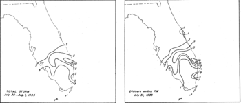
Inland, the storm caused no appreciable effects as it mostly crossed sparsely settled areas.[20][35] Winds at Okeechobee reached 40 to 50 mph (64 to 80 km/h) as the center moved south of that town early on July 31.[16][20] Heavy rains extended over the area, with 24-hour amounts of 12.02 in (305 mm) in Indiantown and 15.6 in (396 mm) at a water transport lock.[35] Additional heavy rains fell over the west coast of Florida, but to a lesser extent than on the east; as was the case elsewhere, notable wind damage was almost non-existent.[10][35] Little immediate damage from wind and rain resulted in the Everglades and near Lake Okeechobee. Winds peaked at 30 mph (48 km/h) in Pahokee, along the lake's eastern shore, and the lake level rose 18 in (457 mm) on July 30–31, which was not enough to induce flooding, although the Kissimmee River, which fed into Lake Okeechobee, rose steadily, owing to heavy rains.[16] The Weather Bureau office in Tampa recorded peak winds of 39 mph (63 km/h).[35] In St. Petersburg, citizens enjoyed a refreshing northeast breeze that removed dead fronds from palms, uprooted scattered plants, and sent waves splashing over seawalls. An anemometer operated by United States Airways at Grand Central Airport, a now-defunct airport on Weedon Island,[46] clocked 40 mph (64 km/h) winds.[19]
Texas and Mexico
As the hurricane affected Brownsville, strong winds—estimated at 80 to 90 mph (130 to 140 km/h)[47]—rent apart tree limbs, tore off roofs, and cracked plate glass windows. Debris covered streets in nearby Port Isabel, where waterfront fishing huts were wrecked. High seas also destroyed many structures on South Padre Island and partly submerged Padre and Brazos islands.[22][48] High tides eroded 500 ft (150 m) of highway on Brazos.[47] Almost no building in Port Isabel went unscathed,[22] with poorly built structures flattened;[47] among the worst hit were at a development company. Early reports confirmed that airborne glass from the local courthouse mildly injured a man in Brownsville.[22] The storm also disrupted communications between the Texas mainland and the barrier islands, where high tides stranded 25–30 campers and a detachment of cavalry from Fort Brown.[22] Two hangars in Brownsville collapsed from the winds as well.[27] A smokestack at a canning facility in La Feria collapsed under the strain of high winds.[47] Water levels along the Rio Grande rose by 14 ft (4.3 m), though the river ultimately fell short of flood stage and spared surrounding areas of damage.[49] The storm ruined between 8–10% of the citrus crop in the Rio Grande Valley, and caused at least one death in Texas.[12][50] Localized losses to the citrus crop reached 25% and upwards of 50% of the cotton crop was blown away in the lower valley region.[47] Total crop damage reached $2 million.[28]
In Mexico, the storm produced torrential rains that resulted in severe flooding, particularly in riparian areas along and near the Santa Catarina River in Monterrey, where at least 31 people died as floods made more than a quarter of the city inaccessible.[23] The collapse of a bridge isolated the Colonia Independencia.[51] Raging waters destroyed 300 homes in one section alone, forcing occupants to flee, and the number of homeless reached the "thousands."[23][52] Governor Lázaro Cárdenas and Mayor Calles called upon all city and state facilities for relief efforts. Many people required evacuation by boat in what were described as "thrilling rescues."[51] The effects of the storm prostrated electrical and communications lines as well as trees in the city.[51] Nearer to the coast, strong winds severely damaged the famed Teatro Reforma, a theater dating to the Maximilian era of the 1860s, in Matamoros, Tamaulipas, where many homes were destroyed.[22]
See also
- 1909 Monterrey hurricane – Caused catastrophic flooding along the Santa Catarina River in Mexico, claiming 4,000 lives
- 1924 Cuba hurricane – Produced heavy rainfall over parts of South Florida, including the worst flooding in some areas until July 1933
- 1933 Treasure Coast hurricane – Was the second hurricane to hit the Treasure Coast in 1933, delivering stronger winds and more adverse effects to the area
- 1933 Cuba–Brownsville hurricane – Was a former Category 5 cyclone that hit South Texas within 24 hours of the preceding storm with 125 mph (205 km/h) winds
References
- ↑ Barnes, Jay (1998). Florida's Hurricane History (1st ed.). Chapel Hill: University of North Carolina Press. pp. 142–144. ISBN 0-8078-4748-8.
- ↑ Williams, John M.; Duedall, Iver W. (2002). Florida Hurricanes and Tropical Storms, 1871–2001 (2nd ed.). Gainesville: University Press of Florida. p. 19. ISBN 0-8130-2494-3.
- ↑ Ludlum, David M. (1963). Early American Hurricanes, 1492–1870. Boston: American Meteorological Society. pp. 124–127. ISBN 0-933876-16-5.
- ↑ Ludlum 1963, pp. 143–147
- 1 2 3 4 5 6 7 8 9 National Hurricane Center; Hurricane Research Division (July 6, 2016). "Atlantic hurricane best track (HURDAT version 2)". United States National Oceanic and Atmospheric Administration. Retrieved December 5, 2016.
- 1 2 3 4 5 6 7 8 9 10 "Documentation of Atlantic Tropical Cyclones Changes in HURDAT (1933 Storm 5 - 2012 Revision)". Atlantic Oceanographic and Meteorological Laboratory. Hurricane Research Division. Retrieved November 27, 2015.
- 1 2 3 "Ocean Gales and Storms, July 1933" (PDF). Monthly Weather Review. 61: 209. July 1933. Bibcode:1933MWRv...61..209.. doi:10.1175/1520-0493(1933)61<209a:OGASJ>2.0.CO;2. Retrieved November 27, 2015.
- 1 2 Dunn, G. E. (December 1933). "Tropical Storms of 1933" (PDF). Monthly Weather Review. 61: 362–363. Bibcode:1933MWRv...61..362D. doi:10.1175/1520-0493(1933)61<362:TSO>2.0.CO;2. Retrieved November 27, 2015.
- 1 2 3 4 5 6 7 Mitchell, Charles L. (July 1933). "Tropical Disturbances of July 1933" (PDF). Monthly Weather Review. 61: 200–201. Bibcode:1933MWRv...61..200M. doi:10.1175/1520-0493(1933)61<200b:TDOJ>2.0.CO;2. Retrieved November 27, 2015.
- 1 2 3 Schoner, R. W.; S. Molansky (July 1956). Rainfall Associated with Hurricanes (and Other Tropical Disturbances) (PDF) (Technical report). National Hurricane Research Project. 3.
- ↑ McDonald, W. F. (July 1933). "North Atlantic Ocean" (PDF). Monthly Weather Review. 61: 208–209. Bibcode:1933MWRv...61..208M. doi:10.1175/1520-0493(1933)61<208:NAO>2.0.CO;2. Retrieved November 28, 2015.
- 1 2 3 Norquest, C. E. (August 1933). "General Summary". Climatological Data. 38: 57–64.
- ↑ "Storm Nears Puerto Rico". The Brownsville Herald. 42 (20). San Juan, Puerto Rico. Associated Press. July 26, 1933. p. 1. Retrieved December 24, 2015 – via Newspapers.com.

- ↑ "Hurricane Moves Toward [Puerto] Rico". Delaware County Daily Times. San Juan, Puerto Rico. United Press. July 25, 1933. p. 1. Retrieved December 24, 2015 – via Newspapers.com.

- 1 2 3 "City Taking Stock Of Water Damage". Palm Beach Post. August 1, 1933.
- 1 2 3 4 "Residents Return to Everglades as Storm Goes Past". Palm Beach Post. August 1, 1933.
- ↑ "Tropical Storm Nears Florida". Port Arthur News. July 30, 1933.
- ↑ "Evergladers Give Experiences During Week-End 'Storm Trip'". Palm Beach Post. August 1, 1933.
- 1 2 "High Winds Blow Over City, Cause Little Damage". St. Petersburg Times. 51 (54). August 1, 1933. Retrieved November 29, 2015.
- 1 2 3 4 5 6 7 8 "Tropical Storm Hits Coast Near Stuart Sunday". Palm Beach Post. July 31, 1933.
- ↑ "Fort Myers Prepares for Tropical Blow". Palm Beach Post. Associated Press. July 31, 1933.
- 1 2 3 4 5 6 "Texas Coastal Towns Lashed by Hurricane". St. Petersburg Times. 51 (58). Associated Press. August 5, 1933. Retrieved November 29, 2015.
- 1 2 3 "Seven Persons Killed in Flood after Storm". St. Petersburg Times. 51 (60). Associated Press. August 7, 1933. Retrieved November 29, 2015.
- 1 2 "Six Are Reported Killed in St. Christopher Blow". Palm Beach Post. July 26, 1933.
- 1 2 "Storm Hits Bahamas". Bismarck Tribune. July 28, 1933.
- 1 2 "Severe Local Storms" (PDF). Monthly Weather Review. 61: 216–218. July 1933. Bibcode:1933MWRv...61..216.. doi:10.1175/1520-0493(1933)61<216:SLSJ>2.0.CO;2. Retrieved November 28, 2015.
- 1 2 "Severe Local Storms" (PDF). Monthly Weather Review. 61: 248–249. August 1933. Bibcode:1933MWRv...61..248.. doi:10.1175/1520-0493(1933)61<248:SLSA>2.0.CO;2. Retrieved December 20, 2015.
- 1 2 "Hurricane Does Big Damage In the Brownsville Section". The Weimar Mercury. 45 (38). Weimar, Texas. August 11, 1933. p. 1. Retrieved December 24, 2015 – via Newspapers.com.

- ↑ David Roth (January 17, 2010). Texas Hurricane History (PDF) (Report). National Weather Service, Weather Prediction Center. Retrieved December 24, 2015.
- 1 2 "Heavy Gale Lashes Virgin Islands". The Brownsville Herald. 42 (20). Saint Thomas, Virgin Islands. Associated Press. July 26, 1933. p. 1. Retrieved December 24, 2015 – via Newspapers.com.

- ↑ "Hurricane Passes Virgin Islands Also Misses Puerto Rico". Evening Report. 43 (227). Saint Thomas, Virgin Islands. International News Service. July 26, 1933. p. 2. Retrieved December 24, 2015 – via Newspapers.com.

- ↑ "No Loss of Life". St. Petersburg Times. 51 (52). Associated Press. July 30, 1933. Retrieved December 20, 2015.
- 1 2 "Damage Done by Storm in Bahamas". Denton Record-Chronicle. 32 (299). Turks Island. Associated Press. July 28, 1933. p. 1. Retrieved December 24, 2015 – via Newspapers.com.

- 1 2 3 "Storm Center Goes Inland Near Stuart Early Sunday Afternoon". Palm Beach Post. July 31, 1933.
- 1 2 3 4 5 6 7 8 Bennett, W. J. (July 1933). "General Summary". Climatological Data. 37: 25–28.
- 1 2 3 "Streets Flooded, Golf Course In Palm Beach Resembles Lakes". Palm Beach Post. August 1, 1933.
- ↑ "Citrus Is Damaged in Fort Pierce Area". Palm Beach Post. August 1, 1933.
- ↑ "Rain Records Are Broken Here With 12 Inches in Day". Palm Beach Post. August 1, 1933.
- 1 2 "Disturbance Passes into Gulf with Wind Velocity Diminished". Palm Beach Post. Associated Press. August 1, 1933.
- ↑ "Storm Travels West Out over Gulf of Mexico". St. Petersburg Times. 51 (54). Associated Press. August 1, 1933. Retrieved November 29, 2015.
- 1 2 3 4 5 "Jupiter Virtually Marooned With Water Flooding Highway". Palm Beach Post. August 1, 1933.
- ↑ "Record Rain Falls". St. Petersburg Times. 51 (54). Associated Press. August 1, 1933. Retrieved November 29, 2015.
- ↑ "Jupiter Bridge Repair Is Included in Budget". Palm Beach Post. August 3, 1933.
- ↑ "Western Sections Are Under Water". Palm Beach Post. August 3, 1933.
- ↑ "Missing Parrot Found Perched in Mango Tree". Palm Beach Post. July 31, 1933.
- ↑ The Weedon Island Story (PDF) (3rd ed.). Tarpon Springs: Pinellas County Department of Environmental Management, Environmental Lands Division. April 2005. p. 33. Retrieved November 29, 2015.
- 1 2 3 4 5 "Citrus and Cotton Crops Bore Brunt Of Loss From Storm". Corsicana Semi-Weekly Light. 48. Brownsville, Texas. August 5, 1933. p. 3. Retrieved December 24, 2015 – via Newspapers.com.

- ↑ "Hurricane Hits Texas Coast with Increased Force". Palm Beach Post. Associated Press. August 5, 1933.
- ↑ "Fear Of Floods On Rio Grande Is Believed Past". The Bonham Daily Favorite. 41 (31). Brownsville, Texas. Associated Press. August 7, 1933. p. 1. Retrieved December 24, 2015 – via Newspapers.com.

- ↑ "Texas Citrus Hit By Tropical Wind". St. Petersburg Times. 51 (59). Associated Press. August 6, 1933. Retrieved November 29, 2015.
- 1 2 3 "Mexico Flood Drowns Seven". The Salt Lake Tribune. Mexico City, Mexico. Associated Press. August 6, 1933. p. 1. Retrieved December 24, 2015 – via Newspapers.com.

- ↑ "11 Drown in Flood". St. Petersburg Times. 51 (62). Associated Press. August 9, 1933. Retrieved November 29, 2015.
