Alberta Highway 36
| ||||
|---|---|---|---|---|
| Veterans Memorial Highway | ||||
 | ||||
| Route information | ||||
| Length: | 681 km (423 mi) | |||
| Major junctions | ||||
| South end: |
| |||
|
| ||||
| North end: |
| |||
| Location | ||||
| Specialized and rural municipalities: | Warner No. 5 County, Taber M.D., Newell County, Special Area No. 2, Paintearth No. 18 County, Flagstaff County, Beaver County, Minburn No. 27 County, Two Hills No. 21 County, St. Paul No. 19 County, Smoky Lake County, Lac La Biche County | |||
| Towns: | Taber, Vauxhall, Killam, Viking, Two Hills | |||
| Villages: | Warner, Vilna | |||
| Highway system | ||||
|
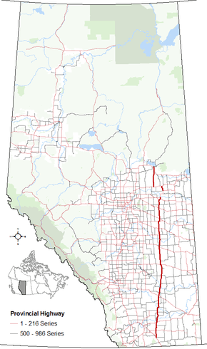
Provincial highways in Alberta
| ||||

.svg.png)
Alberta Provincial Highway No. 36, also named Veterans Memorial Highway,[1] is a north-south highway located in eastern Alberta, Canada. It extends from Highway 4 near the Village of Warner in the south to Highway 55 within the Hamlet of Lac La Biche in the north.[2] Lac La Biche County is lobbying the Government of Alberta to renumber Highway 881 to Highway 36 from Lac La Biche north to Highway 63 south of Fort McMurray.[3][4]
Major intersections
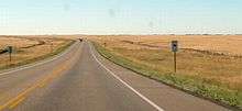
Southbound, south of Vauxhall
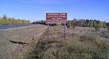
Northbound, south of Lac La Biche, marking the divide between the Arctic basin, and the Hudson Bay basin.
From south to north:
| Rural/specialized municipality | Location | km | mi | Destinations | Notes |
|---|---|---|---|---|---|
| County of Warner No. 5 | Warner | 0 | 0.0 | 4th Avenue | Hwy 36 begins |
| | 1 | 0.62 | |||
| Wrentham | 27 | 17 | |||
| M.D. of Taber | | 36 | 22 | Crosses Chin Lakes | |
| | 45 | 28 | |||
| Taber | 57 | 35 | Hwy 36 branches east Hwy 3 concurrency begins | ||
| 60 | 37 | Hwy 36 branches north Hwy 3 concurrency ends | |||
| | 80 | 50 | Crosses Oldman River | ||
| | 84 | 52 | |||
| Vauxhall | 93 | 58 | Hwy 524 concurrency begins | ||
| | 98 | 61 | Hwy 524 concurrency ends | ||
| | 104 | 65 | |||
| ↑ / ↓ | | 114 | 71 | Crosses Bow River | |
| County of Newell | | 116 | 72 | ||
| | 118 | 73 | UAR 110 west – Scandia | ||
| | 130 | 81 | |||
| | 143 | 89 | |||
| | 153 | 95 | |||
| | 160 | 99 | Interchange proposed[5] | ||
| | 166 | 103 | |||
| Duchess | 172 | 107 | |||
| | 190 | 120 | |||
| ↑ / ↓ | | 191 | 119 | Crosses Red Deer River | |
| Special Area No. 2 | | 213 | 132 | ||
| | 233 | 145 | |||
| | 259 | 161 | |||
| | 273 | 170 | Hwy 36 branches west Hwy 9 concurrency begins | ||
| | 275 | 171 | Hwy 36 branches north Hwy 9 concurrency ends | ||
| | 279 | 173 | Township Road 312 – Hanna | ||
| | 288 | 179 | |||
| County of Paintearth No. 18 | | 339 | 211 | ||
| | 342 | 213 | Hwy 599 concurrency begins | ||
| | 344 | 214 | Hwy 599 concurrency ends | ||
| ↑ / ↓ | | 366 | 227 | Crosses Battle River | |
| Flagstaff County | | 368 | 229 | ||
| | 379 | 235 | UAR 137 west – Galahad | ||
| | 385 | 239 | |||
| Killam | 408 | 254 | |||
| Beaver County | | 434 | 270 | Hwy 36 branches east Hwy 26 concurrency begins | |
| | 437 | 272 | Hwy 36 branches north Hwy 26 concurrency ends | ||
| Viking | 446 | 277 | |||
| 447 | 278 | ||||
| County of Minburn No. 27 | | 484 | 301 | Interchange proposed[6] | |
| | 497 | 309 | |||
| County of Two Hills No. 21 | Two Hills | 517 | 321 | Hwy 36 branches east Hwy 45 concurrency begins | |
| | 521 | 324 | Hwy 36 branches north Hwy 45 concurrency ends | ||
| Duvernay | 527 | 327 | Hwy 29 concurrency begins | ||
| ↑ / ↓ | Brosseau | 529 | 329 | Crosses North Saskatchewan River | |
| County of St. Paul No. 19 | | 548 | 341 | ||
| | 558 | 347 | |||
| St. Brides | 560 | 350 | Hwy 29 concurrency ends | ||
| Ashmont | 576 | 358 | Hwy 36 branches west Hwy 28 concurrency begins | ||
| | 583 | 362 | |||
| Smoky Lake County | | 598 | 372 | ||
| Vilna | 599 | 372 | UAR 116 north | ||
| | 607 | 377 | Hwy 36 branches north Hwy 28 concurrency ends | ||
| Kikino Metis Settlement | 632 | 393 | UAR 213 west – Kikino | ||
| Lac La Biche County | | 660 | 410 | Hwy 55 concurrency begins | |
| Lac La Biche | 681 | 423 | 100 Street north | Hwy 55 concurrency ends Hwy 36 ends | |
1.000 mi = 1.609 km; 1.000 km = 0.621 mi
| |||||
References
- ↑ Province of Alberta (2005-11-11). "Highway 36 renamed Veterans Memorial Highway". Retrieved 2010-01-27.
- ↑ Google (November 4, 2016). "Highway 36 in Alberta" (Map). Google Maps. Google. Retrieved November 4, 2016.
- ↑ "Topics for Ministers Meetings" (PDF). Lac La Biche County. March 2013. Retrieved September 2, 2013.
- ↑ "2015 Provincial Highway 1-216 Progress Chart" (PDF). Alberta Transportation. March 2015. Archived (PDF) from the original on April 10, 2016. Retrieved October 12, 2016.
- ↑ "Figure 4.6 - Freeway Corridor Management Plan: Highway 1, Calgary to Saskatchewan" (PDF) (Map). Alberta Infrastructure and Transportation. McElhanney Consulting Services Ltd. February 21, 2006. Retrieved November 10, 2016.
- ↑ "Highway 16/Highway 36 Interchange Planning Study - Proposed Diamond Interchange Ultimate Stage" (PDF) (Map). Alberta Infrastructure and Transportation. Al-Terra Engineering. Retrieved November 10, 2016.
This article is issued from Wikipedia - version of the 11/10/2016. The text is available under the Creative Commons Attribution/Share Alike but additional terms may apply for the media files.