Arkansas Highway 16
| ||||
|---|---|---|---|---|
 | ||||
| Route information | ||||
| Maintained by AHTD | ||||
| Length: | 260.8 mi[1] (419.7 km) | |||
| Existed: | 1924 – present | |||
| Major junctions | ||||
| West end: |
| |||
|
| ||||
| East end: |
| |||
| Location | ||||
| Counties: | Benton, Washington, Madison, Newton, Pope, Searcy, Van Buren, Cleburne, White | |||
| Highway system | ||||
| ||||

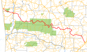
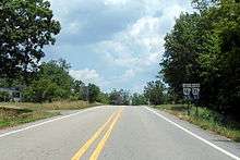
Highway 16 (AR 16, Ark. 16, and Hwy. 16) is an east–west state highway in north Arkansas. The route of 260.77 miles (419.67 km) runs from US Route 412/Highway 59 (US 412/AR 59) in Siloam Springs east across to US Route 67 Business/Highway 36 (US 67B/AR 36) in Searcy.[2][3] With the exception of overlaps of 10 miles (16 km) through Fayetteville, Highway 16 is a narrow, winding, 2-lane road.[1]
Route description
AR 16 begins at US 412/AR 59 in Siloam Springs. It winds south through Ozark National Forest and enters Fayetteville as Wedington Drive. AR turns south at Fulbright Expressway and becomes 15th Street with AR 112 in Fayetteville, passing Baum Stadium. Exiting town, AR 16 meets AR 74 near Elkins and AR 23 in St. Paul.[4][5] The route continues to run along the north edge of Ozark National Forest through unincorporated communities. AR 16 meets AR 21 in Fallsville and briefly exits the forest. Continuing through Ozark National Forest, AR 16 meets AR 7 and AR 123.
Exiting the forest, AR 16 winds before meeting US 65/AR 9/AR 330 north of Clinton. AR 16 and AR 9 concur until Shirley, when AR 16 joins AR 110 and begins south to Fairfield Bay. Crossing Greers Ferry Lake and entering Greers Ferry, AR 16 and AR 110 split, with AR 16 adding AR 92 and AR 225 continuing south. AR 16 meets AR 25/AR 107 (Heber Springs Road) southwest of Pearson. The route continues east, becoming Pangburn Road and running to Pangburn. The route runs south where it meets US 67 BUS/AR 36 and terminates.
Major intersections
| County | Location | mi | km | Destinations | Notes |
|---|---|---|---|---|---|
| Benton | Siloam Springs | ||||
| | |||||
| Washington | Fayetteville | West end of I-49 / US 62 / US 71 overlap; AR 16 west follows exit 64 | |||
| East end of I-49 / US 62 / US 71 overlap; west end of AR 180 overlap; AR 16 east follows exit 62 | |||||
| East end of AR 180 overlap; west end of AR 112 overlap | |||||
| East end of AR 112 overlap | |||||
| Elkins | |||||
| Madison | Crosses | ||||
| Combs | |||||
| Brashears | West end of AR 23 overlap | ||||
| | East end of AR 23 overlap | ||||
| Newton | Fallsville | West end of AR 21 overlap | |||
| Edwards Junction | East end of AR 21 overlap | ||||
| | West end of AR 7 overlap | ||||
| | |||||
| | West end of AR 123 overlap | ||||
| Pope | Sand Gap | East end of AR 7 / AR 123 overlap | |||
| Searcy | Witts Spring | ||||
| Pope | | West end of AR 27 overlap | |||
| | East end of AR 27 overlap | ||||
| Van Buren | Clinton | West end of US 65 / AR 9 overlap | |||
| North end of US 65 overlap | |||||
| | |||||
| Shirley | East end of AR 9 overlap | ||||
| | |||||
| Cleburne | Greers Ferry | West end of AR 92 overlap | |||
| Higden | |||||
| | East end of AR 92 overlap | ||||
| | |||||
| | West end of AR 25 overlap | ||||
| | |||||
| | West end of AR 5 overlap | ||||
| | East end of AR 5 / AR 25 overlap | ||||
| West Pangburn | |||||
| White | Pangburn | ||||
| | |||||
| | |||||
| Searcy | |||||
1.000 mi = 1.609 km; 1.000 km = 0.621 mi
| |||||
Siloam Springs spur
| |
|---|---|
| Location: | Siloam Springs |
| Length: | 0.43 mi (0.7 km) |
Highway 16S (AR 16S, Ark. 16S, Hwy. 16S, and Kenwood Road) is an east–west state highway spur route in Siloam Springs. The route of 0.43 miles (0.69 km) runs from US Route 412/Highway 59 (US 412/AR 59) east to Highway 16.[2] Locally posted as East Kenwood Road, it serves as a short connector route for traffic eastbound on U.S. 412 to access eastbound Highway 16 or for traffic westbound on Highway 16 to access westbound U.S. 412.
References
- 1 2 "[Arkansas] State Highways 2009 (Database)." April 2010. AHTD: Planning and Research Division. Database. Retrieved March 9, 2011.
- 1 2 General Highway Map, Benton County, Arkansas (PDF) (Map). 1:62500. Cartography by Planning and Research Division. Arkansas State Highway and Transportation Department. September 7, 2010. Retrieved February 2, 2012.
- ↑ General Highway Map, White County, Arkansas (PDF) (Map). 1:62500. Cartography by Planning and Research Division. Arkansas State Highway and Transportation Department. July 24, 2008. Retrieved February 2, 2012.
- ↑ Arkansas State Highway and Transportation Department. AHTD Washington County map Retrieved on June 18, 2009.
- ↑ Arkansas State Highway and Transportation Department. AHTD Madison County map Retrieved on June 18, 2009.