Balfour, Mpumalanga
| Balfour | |
|---|---|
|
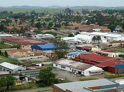
Skyline photo of central Balfour | |
 Balfour  Balfour  Balfour
| |
| Coordinates: 26°39′S 28°35′E / 26.650°S 28.583°ECoordinates: 26°39′S 28°35′E / 26.650°S 28.583°E | |
| Country | South Africa |
| Province | Mpumalanga |
| District | Gert Sibande |
| Municipality | Dipaleseng |
| Established | 1898 |
| Area[1] | |
| • Total | 12.06 km2 (4.66 sq mi) |
| Population (2011)[1] | |
| • Total | 3,201 |
| • Density | 270/km2 (690/sq mi) |
| Racial makeup (2011)[1] | |
| • Black African | 50.2% |
| • Coloured | 1.4% |
| • Indian/Asian | 9.4% |
| • White | 38.4% |
| • Other | 0.6% |
| First languages (2011)[1] | |
| • Afrikaans | 38.6% |
| • Zulu | 23.1% |
| • English | 15.4% |
| • Sotho | 12.3% |
| • Other | 10.7% |
| Postal code (street) | 2410 |
| PO box | 2410 |
| Area code | 017 |
Balfour is a small gold mining and maize farming town in Mpumalanga, South Africa.
The town and post office, some 80 km southeast of Johannesburg, were established on the farms Vlakfontein No. 101 and No. 108 which belonged to Frederick Stuart McHattie, and named McHattiesburg after him in 1897. Proclaimed on 16 February 1898, it was renamed Balfour on 15 February 1905, after Arthur James Balfour, Prime Minister of Great Britain, 1902-1905, who visited South Africa in that year.[2]
References
- 1 2 3 4 "Main Place Balfour". Census 2011.
- ↑ Raper, Peter E. (1987). Dictionary of Southern African Place Names. Internet Archive. p. 68. Retrieved 28 August 2013.
![]() Media related to Balfour at Wikimedia Commons
Media related to Balfour at Wikimedia Commons
This article is issued from Wikipedia - version of the 8/17/2016. The text is available under the Creative Commons Attribution/Share Alike but additional terms may apply for the media files.

.svg.png)