Cabin Branch Pyrite Mine Historic District
|
Cabin Branch Pyrite Mine Historic District | |
|
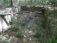
Bin ruins in the Cabin Branch Pyrite Mine Historic District, May 2007 | |
   | |
| Location | Prince William Forest Park, Triangle, Virginia |
|---|---|
| Coordinates | 38°34′36″N 77°21′02″W / 38.57667°N 77.35056°WCoordinates: 38°34′36″N 77°21′02″W / 38.57667°N 77.35056°W |
| Area | 68 acres (28 ha) |
| Built | 1889 |
| NRHP Reference # | 02001517[1] |
| VLR # | 076-0289 |
| Significant dates | |
| Added to NRHP | December 12, 2002 |
| Designated VLR | June 12, 2002[2] |
Cabin Branch Pyrite Mine Historic District is a national historic district located at Prince William Forest Park, Triangle, Prince William County, Virginia. It encompasses 4 contributing sites and 42 contributing structures associated with the Cabin Branch pyrite mine. The pyrite mine opened in 1889, and remained in operation until 1919 or 1920. The property includes a number of capped mine shafts, and the remains of a commissary building and an old mill; and mine structures, including crusher house, mill, mechanical and support buildings, numerous rail lines.[3]
It was added to the National Register of Historic Places in 2002.[1]
References
- 1 2 National Park Service (2010-07-09). "National Register Information System". National Register of Historic Places. National Park Service.
- ↑ "Virginia Landmarks Register". Virginia Department of Historic Resources. Retrieved 5 June 2013.
- ↑ Kay Fanning (October 2000). "National Register of Historic Places Inventory/Nomination: Cabin Branch Pyrite Mine Historic District" (PDF). Virginia Department of Historic Resources. and Accompanying photo
This article is issued from Wikipedia - version of the 11/30/2016. The text is available under the Creative Commons Attribution/Share Alike but additional terms may apply for the media files.


