National Register of Historic Places listings in King William County, Virginia
Location of King William County in Virginia
This is a list of the National Register of Historic Places listings in King William County, Virginia.
This is intended to be a complete list of the properties and districts on the National Register of Historic Places in King William County, Virginia, United States. The locations of National Register properties and districts for which the latitude and longitude coordinates are included below, may be seen in a Google map.[1]
There are 19 properties and districts listed on the National Register in the county, including 1 National Historic Landmark.
- This National Park Service list is complete through NPS recent listings posted December 2, 2016.[2]
Current listings
| [3] |
Name on the Register[4] |
Image |
Date listed[5] |
Location |
City or town |
Description |
|---|
| 1 |
Burlington |
Upload image |
000000001978-01-30-0000January 30, 1978
(#78003023) |
Address Restricted
|
Aylett |
|
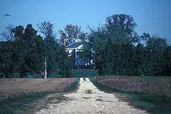
| 2 |
Chelsea |
|
000000001969-11-12-0000November 12, 1969
(#69000253) |
N of jct. of Chelsea Rd. and Rte. 30
37°35′48″N 76°49′46″W / 37.596667°N 76.829444°W / 37.596667; -76.829444 (Chelsea) |
West Point |
|
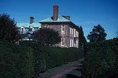
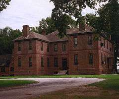
| 3 |
Chericoke |
Upload image |
000000001980-09-08-0000September 8, 1980
(#80004195) |
W of Falls on VA 666
37°38′07″N 77°06′47″W / 37.635278°N 77.113056°W / 37.635278; -77.113056 (Chericoke) |
Falls |
|
| 4 |
Elsing Green |
|
000000001969-11-12-0000November 12, 1969
(#69000252) |
SW of jct. of SR 632 and 623
37°36′25″N 77°02′19″W / 37.606944°N 77.038611°W / 37.606944; -77.038611 (Elsing Green) |
Tunstall |
|
| 5 |
Horn Quarter |
|
000000001980-06-09-0000June 9, 1980
(#80004196) |
NW of Manquin on VA 614
37°46′33″N 77°18′42″W / 37.775883°N 77.311611°W / 37.775883; -77.311611 (Horn Quarter) |
Manquin |
|
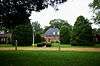
| 6 |
King William County Courthouse |
|
000000001969-10-01-0000October 1, 1969
(#69000251) |
Rte. 619, off VA 30
37°41′17″N 77°00′48″W / 37.688056°N 77.013333°W / 37.688056; -77.013333 (King William County Courthouse) |
King William |
|
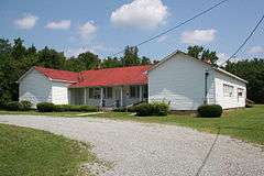
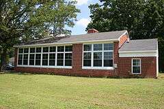
| 7 |
King William Training School |
|
000000002006-09-19-0000September 19, 2006
(#06000872) |
18627 King William Rd.
37°41′50″N 77°02′11″W / 37.697222°N 77.036389°W / 37.697222; -77.036389 (King William Training School) |
King William |
|
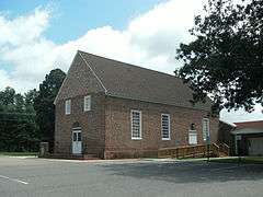
| 8 |
Mangohick Church |
|
000000001972-12-05-0000December 5, 1972
(#72001402) |
VA 638, S of VA 30
37°48′28″N 77°16′21″W / 37.807778°N 77.2725°W / 37.807778; -77.2725 (Mangohick Church) |
Mangohick |
|
| 9 |
Mount Columbia |
Upload image |
000000001989-01-19-0000January 19, 1989
(#88003208) |
Off VA 649, 2.7 mi. W of VA 605
37°42′51″N 77°11′14″W / 37.714167°N 77.187222°W / 37.714167; -77.187222 (Mount Columbia) |
Manquin |
|
| 10 |
Pamunkey Indian Reservation Archaeological District |
Upload image |
000000001982-09-16-0000September 16, 1982
(#82004567) |
Address Restricted
|
Lanesville |
|
| 11 |
Roseville Plantation |
|
000000002007-08-08-0000August 8, 2007
(#07000800) |
3736 Herring Creek Rd
37°51′09″N 77°15′31″W / 37.852503°N 77.258608°W / 37.852503; -77.258608 (Roseville Plantation) |
Aylett |
|
| 12 |
Seven Springs |
|
000000001980-05-06-0000May 6, 1980
(#80004194) |
W of Enfield
37°44′49″N 77°13′44″W / 37.746944°N 77.228889°W / 37.746944; -77.228889 (Seven Springs) |
Enfield |
|
| 13 |
Sharon Indian School |
|
000000002007-07-27-0000July 27, 2007
(#07000764) |
13383 King William Rd.
37°44′03″N 77°06′51″W / 37.734167°N 77.114167°W / 37.734167; -77.114167 (Sharon Indian School) |
King William |
|
| 14 |
St. John's Church |
|
000000001973-04-24-0000April 24, 1973
(#73002214) |
N of Sweet Hall on VA 30
37°36′58″N 76°55′17″W / 37.616111°N 76.921389°W / 37.616111; -76.921389 (St. John's Church) |
Sweet Hall |
|
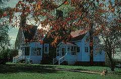
| 15 |
Sweet Hall |
|
000000001977-11-07-0000November 7, 1977
(#77001490) |
S of King William
37°34′12″N 76°54′11″W / 37.57°N 76.903056°W / 37.57; -76.903056 (Sweet Hall) |
King William |
|
| 16 |
West Point Historic District |
|
000000001996-10-03-0000October 3, 1996
(#96001051) |
Kirby, Main, and Lee Sts. from 1st through 13th Sts.
37°31′55″N 76°47′50″W / 37.531944°N 76.797222°W / 37.531944; -76.797222 (West Point Historic District) |
West Point |
|
| 17 |
Windsor Shades |
|
000000001978-05-22-0000May 22, 1978
(#78003025) |
SW of Sweet Hall off VA 30
37°34′13″N 76°54′35″W / 37.570278°N 76.909722°W / 37.570278; -76.909722 (Windsor Shades) |
Sweet Hall |
|
| 18 |
Wyoming |
Upload image |
000000001980-02-08-0000February 8, 1980
(#80004197) |
N of Studley on VA 615
37°43′23″N 77°17′11″W / 37.723056°N 77.286389°W / 37.723056; -77.286389 (Wyoming) |
Studley |
|
| 19 |
Zoar |
Upload image |
000000002007-06-22-0000June 22, 2007
(#06000065) |
VA 608, Upshaw Rd.
37°47′13″N 77°06′46″W / 37.78685°N 77.112861°W / 37.78685; -77.112861 (Zoar) |
Aylett |
|
See also
References
- ↑ The latitude and longitude information provided in this table was derived originally from the National Register Information System, which has been found to be fairly accurate for about 99% of listings. For about 1% of NRIS original coordinates, experience has shown that one or both coordinates are typos or otherwise extremely far off; some corrections may have been made. A more subtle problem causes many locations to be off by up to 150 yards, depending on location in the country: most NRIS coordinates were derived from tracing out latitude and longitudes off of USGS topographical quadrant maps created under the North American Datum of 1927, which differs from the current, highly accurate WGS84 GPS system used by most on-line maps. Chicago is about right, but NRIS longitudes in Washington are higher by about 4.5 seconds, and are lower by about 2.0 seconds in Maine. Latitudes differ by about 1.0 second in Florida. Some locations in this table may have been corrected to current GPS standards.
- ↑ "National Register of Historic Places: Weekly List Actions". National Park Service, United States Department of the Interior. Retrieved on December 2, 2016.
- ↑ Numbers represent an ordering by significant words. Various colorings, defined here, differentiate National Historic Landmarks and historic districts from other NRHP buildings, structures, sites or objects.
- ↑ National Park Service (2008-04-24). "National Register Information System". National Register of Historic Places. National Park Service.
- ↑ The eight-digit number below each date is the number assigned to each location in the National Register Information System database, which can be viewed by clicking the number.
|
|---|
|
Lists
by county | | |
|---|
|
Lists
by city | |
|---|
|
| Other lists | |
|---|
|
|

.jpg)
.jpg)
.jpg)