Calamvale, Queensland
| Calamvale Brisbane, Queensland | |||||||||||||
|---|---|---|---|---|---|---|---|---|---|---|---|---|---|
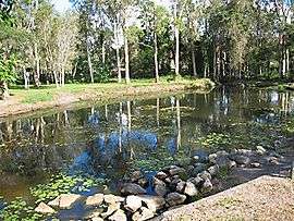
 Part of the Golden Pond wetlands at Calamvale | |||||||||||||
| Population | 15,291 (2011 census)[1] | ||||||||||||
| Postcode(s) | 4116 | ||||||||||||
| Location | 18 km (11 mi) from Brisbane GPO | ||||||||||||
| LGA(s) | City of Brisbane | ||||||||||||
| State electorate(s) |
Electoral district of Algester Electoral district of Stretton | ||||||||||||
| Federal Division(s) | Moreton, Oxley | ||||||||||||
| |||||||||||||
Calamvale is a suburb on the south side of the City of Brisbane, Queensland, Australia.[2] A relatively large suburb, it adjoins Stretton, Parkinson, Sunnybank Hills, Acacia Ridge, Algester and Drewvale. It is 18 kilometres (11 mi) from the Brisbane central business district and close to the Karawatha Forest.
History
Calamvale was named after James Calam, an early settler and prominent landowner in the area. The Calam family built their homestead on a hill at the top of Calam Road near Beaudesert Road. The area was known as Calamvale long before it was officially listed as a suburb in 1972. In 1984, the Calams sold the homestead to the McGuire family, who built the Calamvale Hotel on the land. Urbanisation took place in the early 1990s, and development took place in several stages.
Demographics
The suburb has a medium-high average income per household. The population of Calamvale in 1996 was 6,053; by 2001 it had risen to 9,011, and by 2004 the population was 9,836. The predominant age group in Calamvale is 20–29 years.
Households in Calamvale are primarily couples with children who are likely to be repaying between $1000 and $1200 per month on mortgage repayments. In general, people in Calamvale work in professional occupations. In 1996, 71% of the homes in Calamvale were owner-occupied, compared with 67% in 2001. The median house price for the calendar year 2005 was $359,750.
At the 2011 census the population of Calamvale was 15,291, 50.9% female and 49.1% male.
The median age of the Calamvale population was 31 years of age, 6 years below the Australian median.
44.3% of people living in Calamvale were born in Australia, compared to the national average of 69.8%; the next most common countries of birth were China 8.3%, New Zealand 5.2%, Taiwan 3.7%, India 3.4%, Hong Kong 2.9%.
49.1% of people spoke only English at home; the next most popular languages were 13.1% Mandarin, 6.9% Cantonese, 2.2% Korean, 1.8% Hindi, 1.8% Vietnamese.
Education
The schools in Calamvale include Calamvale Community College (which combines a primary and a secondary school), Stretton State College (Prep year to Year 10), and Calamvale Special School.
Sporting
The Calamvale Leopards are the local Australian Football League team.
Transport
No train stations are in Calamvale, although Altandi and Runcorn train stations are only about a five-minute drive away. Travel to the Brisbane CBD is roughly 30 minutes (off-peak) by car, 40–55 minutes by bus, and 30–45 minutes by train from Runcorn and Altandi railway stations.
Calamvale is serviced by nine bus routes operated by Brisbane Transport and Park Ridge Transit, as listed below. It is in Zone 5 of the TransLink zoning scheme.
Other services
There is a police station and several churches, including:
- Coptic Orthodox Church of St Mary and St Joseph
- Salvation Army Worship Centre
- Trinity Independent Baptist Church
- Resurrection Life Ministries on Beaudesert Road
Golden Pond wetlands
An eco-friendly feature of Calamvale is the Golden Pond Wetlands attached to Calamvale Creek.
A natural creek (part of a longer channel known as Scrubby Creek, but locally known as Calamvale Creek) and a riparian wetland run through the lower part of Calamvale. In the late 1990s, two constructed wetlands relying on storm water runoff were built upstream of the creek on each side of Golden Avenue. They are known as the Golden Pond wetlands.
The wetlands and creek, collectively called the Golden Pond wetland system, provide a small wildfowl habitat and a storm water treatment train designed to improve the quality of storm water runoff as it progresses down the creek.[3]
Treatment train
The treatment train is made up of several parts, and purifies water as it flows through each part.
An upstream storm water drainage channel runs into a sediment basin, which collects the heaviest sediments and allows better-quality water to flow into Wetland 1. Water flows through a gross pollutant trap into Wetland 2, which was originally a small farm dam on the south side of the Golden Avenue road bridge. Overflow water from Wetland 2 runs into a natural riparian wetland fringed with melaleucas, and this runs into a natural creek with small lagoons.
Wildlife
The Calamvale wetlands and creek provide a home and a retreat for ducks, egrets, cormorants, spoonbills, herons, water dragons, turtles, eels, and a large number of other wildfowl and animals.[4]
Water quality
Environmental engineers from Brisbane’s Griffith University have conducted numerous studies on water quality at the creek and wetlands, and have presented papers at conferences internationally on the design and effectiveness of the treatment train.[5]
Notable people
Actor Russell Dykstra grew up in the suburb, frequently entertaining commuters on the local 141 bus with his self-styled pantomimes while taking the long commute into St Laurence's College in South Brisbane as a schoolboy from 1979 to 1981.
References
- ↑ Katherine Feeney (2 August 2012). "Brisbane booming in the middle and round the edges". Brisbane Times. Fairfax Media. Retrieved 2 August 2012.
- ↑ "Calamvale (entry 47596)". Queensland Place Names. Queensland Government. Retrieved 22 September 2015.
- ↑ Margaret Greenway. Stormwater Treatment Trains in Subtropical Australia — Wetland and Pond Systems: How effective are they in improving water quality and enhancing ecosystem biodiversity?. Retrieved 2 August 2012.
- ↑ Critters of Calamvale Creek. Retrieved 2 August 2012.
- ↑ Golden Pond wetland system, Calamvale: research papers. Retrieved 2 August 2012.
External links
Coordinates: 27°37′26″S 153°03′00″E / 27.62389°S 153.05000°E