Canton of Armentières
| Canton of Armentières | |
|---|---|
| French canton | |
|
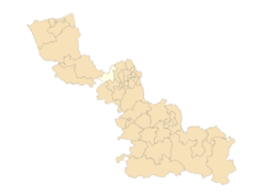
Map of the canton of Armentières within the Nord department | |
| Country | France |
| Region | Hauts-de-France |
| Department | Nord |
| Arrondissement | Lille |
| Seat | Armentières |
| Communes | 11 |
| Area¹ | |
| • Total | 79.53 km2 (30.71 sq mi) |
| Population (2012) | |
| • Total | 64,936 |
| • Density | 820/km2 (2,100/sq mi) |
| ¹ French Land Register data, which exclude estuaries, and lakes, ponds, and glaciers larger than 1 km2. | |
The Canton of Armentières is a canton of the Nord département in France.
Since the French canton reorganisation which came into effect in March 2015, the communes of the canton of Armentières are:[1]
- Armentières (chief town)
- Bois-Grenier
- Capinghem
- La Chapelle-d'Armentières
- Deûlémont
- Erquinghem-Lys
- Frelinghien
- Houplines
- Pérenchies
- Prémesques
- Warneton
References
Coordinates: 50°40′27″N 2°54′28″E / 50.67417°N 2.90778°E
This article is issued from Wikipedia - version of the 11/18/2016. The text is available under the Creative Commons Attribution/Share Alike but additional terms may apply for the media files.
