Cape St. Francis
| Cape St. Francis | |
|---|---|
|
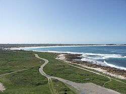
View of Cape St. Francis from the Seal Point Lighthouse | |
 Cape St. Francis  Cape St. Francis  Cape St. Francis
| |
| Coordinates: 34°11′49″S 24°50′17″E / 34.19694°S 24.83806°ECoordinates: 34°11′49″S 24°50′17″E / 34.19694°S 24.83806°E | |
| Country | South Africa |
| Province | Eastern Cape |
| District | Sarah Baartman |
| Municipality | Kouga |
| Area[1] | |
| • Total | 4.38 km2 (1.69 sq mi) |
| Population (2011)[1] | |
| • Total | 342 |
| • Density | 78/km2 (200/sq mi) |
| Racial makeup (2011)[1] | |
| • Black African | 3.5% |
| • Coloured | 1.8% |
| • White | 94.7% |
| First languages (2011)[1] | |
| • English | 55.6% |
| • Afrikaans | 42.1% |
| • Xhosa | 1.8% |
| • Other | 0.6% |
Cape St. Francis (Afrikaans: Kaap St Francis) is a village in South Africa, situated on a headland in the Eastern Cape Province. It is popular for its clean beaches and as a surfing location.
The village is home to a Penguin Rescue and Rehabilitation Center as well as the Seal Point Lighthouse.[2]
The Irma Booysen Floral Reserve is the home to many species of flowers and plants.
The adjacent village, St Francis Bay, was the site of "ten-million-to-one" surfing waves seen in the 1966 surf/travel documentary, The Endless Summer.
Cape St. Francis is now known as one of the best surfing locations. Given its geological location, it is susceptible to swell year round from large low pressure systems that form between Antarctica and the southern tip of Africa. When large south west swell wrap around the coastline of the region and the prevailing offshore winds come up, the surfing is as good as it gets.
See also
- Port St. Francis
- St. Francis Bay
- Venpet-Venoil collision
References
- 1 2 3 4 "Main Place Cape St. Francis". Census 2011.
- ↑ http://www.penguin-rescue.org.za

.svg.png)