Centro, Montevideo
| Centro | |
|---|---|
| Barrio | |
|
The Edificio Rex and the El Entrevero fountain in Plaza Fabini | |
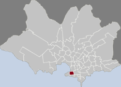
 Location of Centro in Montevideo | |
| Coordinates: 34°54′13″S 56°11′18″W / 34.90361°S 56.18833°WCoordinates: 34°54′13″S 56°11′18″W / 34.90361°S 56.18833°W | |
| Country |
|
| Department | Montevideo Department |
| City | Montevideo |
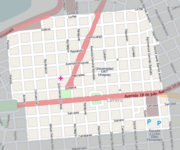
Centro is the inner city barrio (neighbourhood or district) of Montevideo, Uruguay. Its main avenue is 18 de Julio Avenue. It is delimited by La Paz Str. to the North, Florida Str. (North of 18 de julio Av.) and Andes Str. (South of 18 de Julio Av.) to the West, Canelones Str. to the South and Barrios Amorin Str. to the East. It used to be the main commercial venue of the city, but after the opening of the first malls, many small stores started closing down. Now, that process is being reverted and the area is coming back to life.
History

Because of the military origins of Montevideo, it had been forbidden to build anything permanent in the area outside the walls of the city up to the time that Uruguay gained Independence. That area was called Campo de Marte or ejido (common). Around 1750, the colonial Gobernación Política y Militar de Montevideo traced the limits of the forbidden area at "a canonball's reach" from the city's fortifications by a line or "cordón". Eventually, Cordón became the name of the area outside the Campo de Marte.[1]
In 1829, four years after the declaration of Independence, the National Assembly decided to pull down the fortifications of the Ciudad Vieja and extend the city to form the "Ciudad Nueva". At the time, the population of Montevideo was around 14,000. The plans for some additional 160 city blocks were drawn by military engineer Don José María Reyes. That extension is the actual barrio of Centro. The plans included a new square, which in 1840 took on the name Plaza Cagancha, while the names of the streets were given by Andrés Lamas from 1843 on. The development of this area was very slow due to the "Guerra Grande" of 1839-1852. In 1867 a pillar with the statue of Peace (La Paz) was erected in the centre of Plaza Cagancha.
Squares and buildings
Along 18 de Julio Avenue there are two central and frequented squares: Plaza Fabini, commonly called Plaza del Entrevero because of the sculpture of its main fountain, called "The Entrevero", by José Belloni, and Plaza Cagancha, commonly called Plaza Libertad. The former is mostly used as a relaxation area and the latter is mostly a place where craftsmen and other small vendors exhibit their work and products for sale.
One of the most architecturally notable buildings of the Centro, is the Palacio Lapido, designed by Juan Aubriot and built in 1933, a National Heritage Site since 1989.[2] Other National Heritage Sites of the Centro are the Jockey Club, the Sala Zitarrosa on Plaza Fabini, the Ateneo de Montevideo and the Palacio Piria (seat of the Supreme Court) on Plaza Cagancha, the Palacio Santos (seat of the Uruguayan Ministry of Foreign Affairs) and the Mercado de la Ambundancia. The Centro is also home to the Palacio Municipal, the building of the City Hall, with a wide public area in front of it featuring an impressive copy of Michaelangelo's David.
Places of worship
Several temples have been built in this important neighbourhood.
- St. Michael Garicoits Church, popularly known as "Iglesia de los Vascos" (Roman Catholic, Betharram Fathers)
- Church of St. Joseph and St. Maximilian Kolbe, also known as "Conventuales" (Roman Catholic, Conventual Franciscans)
- Central Methodist Church (Methodist)
- Uruguayan Jewish Community (Synagogue)
- New Jewish Congregation (Conservative synagogue)
- Vaad Ha'ir (Synagogue)
- Uruguay Islamic Center (Muslim)
Street map and main attractions
|
|
|
See also
Notes
External links
| Wikimedia Commons has media related to Centro, Montevideo. |


