Islands of Shanghai
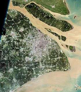
The islands of Shanghai are those under the jurisdiction of the Shanghai municipal government. They comprise three large inhabited islands and a shifting number of smaller, uninhabited ones. Most are alluvial islands in the Yangtze River Delta in China, although a number of islands in Hangzhou Bay off Jinshan District are also administered by Shanghai. The alluvial islands are relatively young and their number varies over time. In 2006, the city's 19 uninhabited islands covered 226.27 square kilometers (87.36 sq mi), with a total coastline length of 309 kilometers (192 mi).[1]
The Yangshan area of the Port of Shanghai is also located on two islands, Greater and Lesser Yangshan in Hangzhou Bay, but these are administered as part of Zhejiang's Shengsi County.
Chongming County
All three inhabited islands of Shanghai are alluvial islands in the Yangtze estuary between the Municipality of Shanghai and Jiangsu Province. They are administered as Chongming County, with its seat at Chengqiao on Chongming Island. The county was added to Shanghai from Jiangsu in 1958 and remains mostly rural: In 2008, its registered population of 693 000 included 450 300 farmers.[2]
Chongming Island (1,267 km2 or 489 sq mi[2]) is now the second-largest island of mainland China (after Hainan). The natural expansion of the island has been greatly accelerated by reclamation projects, which doubled its size between 1950 and 2010. This growth caused it to absorb the former island of Yonglongsha, creating a long pene-exclave of Jiangsu on its northern shore administered as the townships of Haiyong and Qilong. The island was connected to Changxing by the Yangtze Bridge in 2009[3] and to Qidong in Jiangsu by the Chongqi Bridge in 2011.[4] The Chonghai Bridge, to Haimen in Jiangsu, remains under construction[5] and plans for Shanghai's S7 (Huchong) Expressway call for the creation of a bridge directly from Baoshan District to Chengqiao.
Changxing Island (88.54 km2 or 34.19 sq mi[6]) lies between Chongming and Shanghai in the southern channel of the Yangtze opposite the mouth of the Huangpu, the major river of central Shanghai. It is connected to Chongming by the Yangtze Bridge and Shanghai's Pudong New Area by the Yangtze Tunnel.
Hengsha Island (55.74 km2 or 21.52 sq mi[6]) lies to Changxing's east and is connected with the mainland and other islands by ferry service.
Pudong New Area
Jiuduansha is an intertidal wetland. The 114.6 km2 (44.2 sq mi) area above sea level comprises four major shoals: Upper, Middle, Lower, and South Jiuduansha.[7][8] These shoals and the waters surrounding them to a depth of 6 meters or 20 feet (occupying an additional 308.6 km2 or 119.2 sq mi) form the Jiuduansha Wetland Nature Reserve, a nationally-protected area of Shanghai.[7] The shoals began forming during the Yangtze floods of the late 1940s and early 1950s,[7] but were developed and protected as a replacement for the wetlands of eastern Pudong during the construction of Shanghai's international airport in the 1990s.[10] The cordgrass introduced in 1995 has succeeded in stabilizing the shoals but is now considered to be highly invasive, displacing the native reeds and bullrushes[11][12] and degrading parts of the wetlands.[10] A wetland museum, as well as a Science Popularization Park on about 5 square kilometers (1.9 sq mi) of the island, are planned to increase public awareness and support.[10]
Jinshan District
Dajinshan Island (t 大金山島, s 大金山岛, p Dàjīnshān Dǎo, lit. "Greater Gold Mountain Island"), Xiaojinshan Island ("Lesser Gold Mountain Island"), and Fushan Island in Jinshan District are nature reserves under city jurisdiction.[1] They are located in Hangzhou Bay. Dajinshan has the highest point in Shanghai with an elevation of 103.4 meters (339 ft).
See also
References
- 1 2 China Daily
- 1 2 "Chongming County" in the Encyclopedia of Shanghai, pp. 50 ff. Shanghai Scientific & Technical Publishers (Shanghai), 2010. Hosted by the Municipality of Shanghai.
- ↑ "Bridge-Tunnel Linking Chongming Island Opens to Traffic". Shanghai Daily. 31 Oct 2009. Accessed 3 Nov 2009.
- ↑ "'长江入海第一桥'崇启大桥24日正式建成通车" ["'Chángjiāng Rùhǎi Dì Yī Qiáo' Chóngqǐ Dàqiáo 24 Rì Zhèngshì Jiànchéng Tōngchē", "Chongqi Bridge, the 'First Bridge of the Yangtze Delta', Officially Opens to Traffic on the 24th"]. 中国广播网 [Zhōngguó Guǎngbōwǎng]. 24 Dec 2011. (Chinese)
- ↑ "Major Construction Completed on Chongqi Bridge". People's Daily. 21 Sept 2011. Accessed 19 Oct 2011.
- 1 2 Shanghai Statistical Bureau Yearbook 2007
- 1 2 3 "Overview". The Shanghai Jiuduansha Wetland Nature Reserve (Shanghai), 2014.
- ↑ Also known by the Mandarin form of their Chinese names: Shangsha, Zhongsha, Xiasha, and Jiangyanansha.[9] The last is named for its proximity to the site of the 1948 explosion and sinking of the SS Kiangya.
- ↑ "Introduction". The Shanghai Jiuduansha Wetland Nature Reserve (Shanghai), 2014.
- 1 2 3 "Fourth Island Wetland Emerging", pp. 1–2. Shanghai Daily. 8 Dec 2009. Hosted at China.org.
- ↑ Pratolongo, Paula & al. "Temperate Coastal Wetlands: Morphology, Sediment Processes, and Plant Communities" in Coastal Wetlands: An Integrated Ecosystem Approach, p. 105. Elsevier (Amsterdam), 2009.
- ↑ Scott, David B. Coastal Wetlands of the World: Geology, Ecology, Distribution, and Applications, pp. 229 f. Cambridge University Press (Cambridge), 2014.
External links
- "Islands and Shoals of Shanghai" at the Office of Shanghai Chronicles (Chinese)
