Cheruthoni
| Cheruthoni ചെറുതോണി | |
|---|---|
| village | |
|
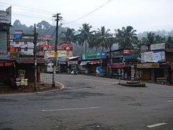
Cheruthoni junction | |
 Cheruthoni  Cheruthoni Location in Kerala, India | |
| Coordinates: 9°46′25″N 77°2′07″E / 9.77361°N 77.03528°ECoordinates: 9°46′25″N 77°2′07″E / 9.77361°N 77.03528°E | |
| Country |
|
| State | Kerala |
| District | Idukki |
| Government | |
| • Type | Panchayath |
| Languages | |
| • Official | Malayalam, English |
| Time zone | IST (UTC+5:30) |
| PIN | 685602 |
| Vehicle registration | KL-06 |
| Nearest city | Kattappana |
Cheruthoni is a town on the Cheruthoni River, a major tributary of the Periyar River, the second longest river in Kerala state, South India. The area is known for its dams, which provide hydroelectric power to the region.
Location

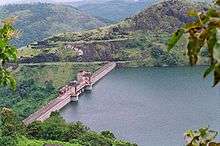
The town is adjacent to the famous Idukki Arch Dam and the Cheruthoni dam. These dams, along with the Kulamavu Dam, form the Idukki Reservoir. Cheruthoni is part of Vazhathope Panchayat, in the Idukki District. Other villages adjacent to Cheruthoni include Vazhathope, Thadiyanpadu, Karimban, Manjappara, Maniyarankudi, Bhoomiyamkulam, Peppara, Manjikkavala and Painavu.
Origin
Following a famine in the 1940s, the government allowed farmers to migrate to unoccupied arable lands in the mountains, where they cleared the land for agriculture. Later, the region was identified as an ideal spot for a hydroelectric project. The Hindustan Construction Company was contracted to build the dams on behalf of the Kerala State Electricity Board. At this point, Cheruthoni began to grow.
History
During the 1960s, a majority of the people living in Cheruthoni were not Keralites, but Sikhs from Punjab (who constituted the workforce of Hindustan Construction Company) and manual laborers from neighbouring Tamil Nadu.
