Clapham's Ferry
|
Clapham's Ferry | |
 | |
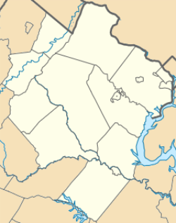   | |
| Location | 44344 E. Spinks Ferry Rd., Leesburg, Virginia |
|---|---|
| Coordinates | 39°13′19″N 77°27′52″W / 39.22194°N 77.46444°WCoordinates: 39°13′19″N 77°27′52″W / 39.22194°N 77.46444°W |
| Area | 354.9 acres (143.6 ha) |
| Architectural style | Federal |
| NRHP Reference # | 97001076[1] |
| VLR # | 053-0071 |
| Significant dates | |
| Added to NRHP | September 4, 1997 |
| Designated VLR | March 19, 1997[2] |
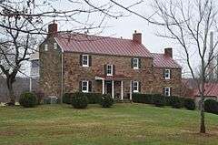
Clapham's Ferry, also known as Spinks Ferry, Lost Corner Farm, and Riverside, is a historic home located near Leesburg, Loudoun County, Virginia. It consists of a 2 1/2-story, three bay, Federal style main block of red sandstone, with a two-story sandstone kitchen addition built about 1849. It has a standing seam metal gable roof. Also on the property are the contributing log kitchen building, meat house, bank barn, corn crib, and tenant house. The property is also historically significant as the site of an early ferry crossing connecting Loudoun County, Virginia, with Maryland.[3]
It was listed on the National Register of Historic Places in 1997.[1]
References
- 1 2 National Park Service (2010-07-09). "National Register Information System". National Register of Historic Places. National Park Service.
- ↑ "Virginia Landmarks Register". Virginia Department of Historic Resources. Retrieved 5 June 2013.
- ↑ Nathaniel Palmer Neblett (January 1997). "National Register of Historic Places Inventory/Nomination: Clapham's Ferry" (PDF). Virginia Department of Historic Resources. and Accompanying photo

This article is issued from Wikipedia - version of the 11/30/2016. The text is available under the Creative Commons Attribution/Share Alike but additional terms may apply for the media files.