Climate of Argentina
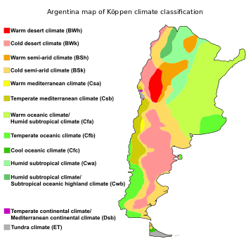
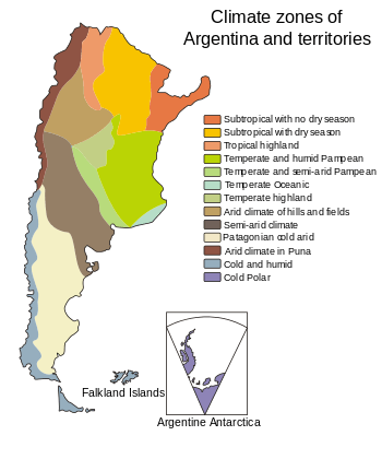
The climate of Argentina is a complex subject: the vast size of the country and considerable variation in altitude make for a wide range of climate types. Argentina has four seasons: winter (June–August), spring (September–November), summer (December–February) and autumn (March–May), all featuring different weather conditions. Summers are the warmest and wettest season in most of the country except in most of Patagonia where it is the driest season. Winters are normally mild in the north, cool in the center and cold in the southern parts with the latter experiencing frequent frost and snow. Because southern parts of the country are moderated by the surrounding oceans, the cold is less intense and prolonged than areas at comparable latitudes in the northern hemisphere. Spring and autumn are transition seasons that generally feature mild weather.
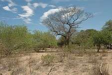
Many regions have different, often contrasting, microclimates. In general, northern parts of the country are characterized by hot, humid, rainy summers and mild winters with periodic droughts. Mesopotamia, in the northeast is characterized by high temperatures and abundant precipitation throughout the year with droughts being uncommon. West of this lies the Chaco region, which is the warmest region in Argentina. Precipitation in the Chaco region decreases westwards, resulting in the vegetation changing from forests in the east to shrubs in the west. Northwest Argentina is predominantly dry and hot although the rugged topography makes it climatically diverse, ranging from the cold, dry Puna to thick jungles. The center of the country, which includes the Pampas to the east and the drier Cuyo region to the west has hot summers with occasional tornadoes and thunderstorms, and cool, dry winters. Patagonia, in the southern parts of the country has a dry climate with warm summers and cold winters characterized by strong winds throughout the year and one of the strongest precipitation gradients in the world. High elevations at all latitudes experience cooler conditions, and the mountainous zones can see heavy snowfall.
The geographic and geomorphic characteristics of Argentina tend to create extreme weather conditions, often leading to natural disasters that negatively impact the country both economically and socially. The Pampas, where many of the large cities are located, has a flat topography and poor water drainage, making it vulnerable to flooding. Severe storms can lead to tornados, damaging hail, storm surges, and high winds, causing extensive damage to houses and infrastructure, displacing thousands of people and causing significant loss of life. Extreme temperature events such as heat waves and cold waves impact rural and urban areas by negatively impacting agriculture, one of the main economic activities of the country, and by increasing energy demand, which can lead to energy shortages.
Argentina is vulnerable and will likely be significantly impacted by climate change. Temperatures have increased in the last century while the observed changes in precipitation are variable, with some areas receiving more and other areas less. These changes have impacted river flow, increased the frequency of extreme weather events, and led to the retreat of glaciers. Based on the projections for both precipitation and temperatures, these climatic events are likely to increase in severity and create new problems associated with climate change in the country.
Seasons
In Argentina, the climate is divided into four, well defined seasons: winter, spring, summer and autumn.[3]
Winter
.jpg)
In winter (June–August), the northern parts of Argentina are generally warm, the central parts mild, and the southern parts cold with frequent frost and snow. The climate of the southern parts of the country is moderated by the surrounding oceans, resulting in cold weather that is less intense and prolonged than at comparable latitudes in the northern hemisphere.[4] The northern parts of the country have the warmest temperatures, with an average of 14 °C (57 °F); the central parts are cooler, with an average of 10 °C (50 °F). In the extreme south, mean temperatures are below 4 °C (39 °F). At higher altitudes in the Andes, average winter temperatures are below 0 °C (32 °F). June and July temperatures are normally similar to each other; however, in August temperatures see a rise of about 2 °C (4 °F).[5]
Precipitation varies widely during the winter months. The highest are in the extreme northern part of the Littoral region and northwestern parts of Patagonia,[note 2] where mean winter precipitation exceeds 250 mm (10 in). Most of the humid Pampas, averages between 75 and 200 mm (3 and 8 in) while in the north, in areas bordering the Andes, it averages less than 10 mm (0.4 in).[5]
Spring
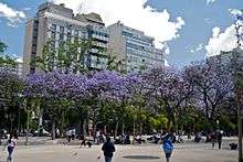
Spring (September–November) is similar to autumn, with mild days and cool nights. During mid-October a large variety of wild and urban flora are in bloom. Temperatures range from 20 °C (68 °F) in the north to 14 °C (57 °F) in the center, and 8 to 14 °C (46 to 57 °F) in most of Patagonia. Tierra del Fuego Province and the higher altitudes of the Andes have the coolest springs, with mean temperatures below 8 °C (46 °F). Temperatures grow warmer as spring progresses.[8]
During spring, precipitation in the country varies, with the greatest amounts being in northern Buenos Aires Province and the Littoral region, where the average precipitation exceeds 250 mm (10 in). Arid regions (Arid Diagonal) have the lowest spring precipitation, with an average precipitation of less than 50 mm (2 in).[8]
Summer
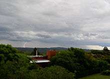
In summer (December–February), temperatures range from an average of 26 °C (79 °F) in the north to a mean of 20 °C (68 °F) in the center of the country except for the southeastern parts of Buenos Aires Province, where temperatures are cooler in summer due to the maritime influence.[2] In the extreme south of the country, the temperature averages 12 °C (54 °F); at very high altitudes, the average is below 10 °C (50 °F).[9]
During summer, mean precipitation varies throughout the country: the eastern parts of Salta Province, Jujuy Province, northern Tucumán Province and all of Misiones Province are the wettest, receiving more than 400 mm (16 in) of precipitation during the season.[6][9] Most of the Littoral region and Buenos Aires Province, average between 200 and 300 mm (8 and 12 in).[9] On the other hand, the Patagonia region is dry, with precipitation averaging less than 50 mm (2 in) – and occasionally below 25 mm (0.98 in) – much lower than other regions;[6][9] Patagonia receives a monthly precipitation of 10 to 25 mm (0.4 to 1.0 in). In the central and northern parts of the country, January is usually the wettest month, with an average monthly precipitation of 100 mm (4 in) in most places, even exceeding 200 mm (8 in) in some places.[6]
Autumn
Autumn (March–May) is generally mild. Some forests and vineyards display red and orange autumn foliage, especially in mid-April. Frost arrives notably earlier in the south and later in the north. Mean temperatures can exceed 22 °C (72 °F) in the northern parts of the country, while they can touch 16 °C (61 °F) in most of the central parts of the country, and less than 6 °C (43 °F) at the higher altitudes.[10] As autumn progresses, mean temperatures fall in all regions, with March warmer than May. In the north, mean temperatures range from 24 °C (75 °F) in March to 18 °C (64 °F) in May. In the central parts of the country, mean temperatures in March are between 18 and 22 °C (64 and 72 °F), dropping to 10 and 14 °C (50 and 57 °F) in May. The mean temperature in Tierra del Fuego Province in the extreme south is 10 °C (50 °F), and occasionally lower.[11]
Precipitation is highest in northeast Argentina and lowest in the Patagonia and Cuyo regions.[note 3][10] In northeast Argentina, mean precipitation can exceed 400 mm (16 in) while in most of Buenos Aires Province and northwest Argentina,[note 4] mean autumn precipitation ranges between 200 and 500 mm (8 and 20 in).[10][11] In most of the western parts of northwest Argentina, Patagonia (except for western Patagonia where precipitation is higher, averaging 100 to 200 mm (4 to 8 in)) and Cuyo regions, precipitation can average less than 50 mm (2 in).[10] In the northwest, precipitation decreases as autumn progresses, ushering in the dry season. For example, in Tucuman Province, March averages more than 200 mm (8 in) of precipitation while May averages less than 50 mm (2 in). In contrast, precipitation increases in Patagonia, particularly in the western parts where May precipitation can exceed 100 mm (4 in).[11]
Factors that influence the climate
Different meteorological factors affect the Argentine climate.[3] Some of these factors are local while others come from other countries.[3]
Geographic factors
The most important geographical factors that influence the climate of Argentina are latitude, elevation, and distance from the sea.[13]:6 With Argentina extending from 22oS to 55oS, there are differences in the amount of incoming solar radiation and the amount of daylight received in each season, which affects temperature.[13]:6 Thus, temperatures decrease from north to south due to the differences in latitudes.[3]
Although the centre and the eastern parts of the country are mostly flat, the west is mountainous.[4] Both the Andes and Sierras Pampeanas affect the climate of Argentina, leading to differences in temperature, pressure, and spatial distribution of precipitation depending on the topography and altitude.[13]:8 Here, the Andes exert an important influence on the climate.[13]:7 Owing to the higher altitudes of the Andes north of 40oS, they completely block the normal westerly flow, preventing low pressure systems containing moisture from the Pacific Ocean from coming in.[14][13]:7[15] Thus, much of Argentina north of 40oS is dominated by wind circulation patterns from the South Atlantic High.[14][15] South of 40oS, the Andes are lower in altitude, allowing much of Patagonia to be dominated by westerly winds and air masses from the Pacific Ocean.[14][15] However, the north–south orientation of the Andes creates a barrier for humid air masses originating from the Pacific Ocean.[16][17] This is because they force these air masses upwards, cooling adiabactically.[14][16][17] Most of the moisture is dropped on the Chilean side, causing abundant precipitation and cloudiness while on the Argentine side, the air warms adiabatically, causing it to become drier as it descends.[16][17] Thus, an extensive rain–shadow is present in much of Patagonia, causing it to receive very little precipitation.[14][16][17] The Sierras Pampeanas influences the climate on a much smaller scale than the Andes.[13]:7-8
Distance from the sea is another important geographic factor.[13]:8 Owing to the shape of the country, the close proximity to the ocean means that most of the country, excluding the north is moderated by the surrounding oceans, leading to lower thermal amplitudes than comparable latitudes in the northern hemisphere.[14] The two main currents that impact the climate of Argentina are the Brazil Current from the north and the Malvinas Current from the south (a branch of the Antarctic Circumpolar Current).[18] The Brazil Current transports warm subtropical waters southwards while the Malvinas Current transports cold, subantarctic waters northwards.[19] The Malvinas Current cools the coastal areas,[20][21] particularly during winter when the current is more stronger.[19] Thus, coastal areas of the Pampas have cooler summers and a longer frost period owing to the cold Malvinas Current.[22] As well, it is the main factor in making Tierra del Fuego colder than at comparable latitudes in the northern hemisphere in Europe since it is influenced by the cold Malvinas Current rather than the warm North Atlantic Current.[23]:17
Atmospheric Circulation
The South Atlantic High and the South Pacific High both influence the pattern of winds in Argentina.[3] Owing to the greater high of the Andes at latitudes north of 40oS, much of Argentina is dominated by wind circulation patterns from the South Atlantic High.[14][15] The South Atlantic High transports moisture from the Atlantic Ocean to Argentina.[3][24] This occurs throughout the year due to the atmospheric pressure being lower on land than in the ocean.[25] Much of the north and central parts of the country are affected by the South Atlantic High, with a strong influence in the eastern parts than in the west.[3] This is due to the eastern parts being more frequently affected by the South Atlantic High, causing precipitation to decrease westwards.[14]
Throughout the year, the South Pacific High influences the climate by bringing cold, moist air masses originating from Patagonia.[26][27] During the most intense cold waves, they form when a transient high pressure system located in the South Pacific Ocean moves eastwards to the southern tip of South America.[28][29] As it begins to move, this high pressure system strengthens the South Pacific High and is forced to move southwards to south of 40oS where the Andes are shorter in height.[30] As well, an upper level ridge forms over the South Pacific Ocean along with an upper level trough extending from subtropical latitudes to the South Atlantic Ocean.[31][30] At the same time, a low pressure system forms over the South Atlantic Ocean which eventually strengthens.[29][31][30] The formation a cold front associated with it moves to the northeast owing to the topographic barrier that the Andes forms.[32] The passage of the cold front to the northeast leads to the movement of the high pressure system from the South Pacific Ocean into the southern tip of South America.[28][32][33] All of these conditions lead to strong anticyclogenesis to the east of the Andes and thus, the high pressure system intensifies as it enters southern Argentina.[28][30][32] When both the high pressure system (over southern Argentina) and low pressure system strengthen, it creates a very strong pressure gradient that draws cold air from the south, strengthening southerly winds.[29][31][32] Owing to the topographic barrier of the Andes, it forces and channels the cold air to accumulate on the eastern side of the Andes.[30] This generates an ageostropic component from the south (due to a reduction in the Coriolis force caused by accumulation of cold air on the eastern side of the Andes) that draw this cold air northwards, which is driven by this pressure gradient.[29][32] Cold air can move northwards until 18oS when the blocking effect of the Andes is smaller due to a change in its orientation.[29] Overall, these conditions results in the coldest temperatures due to the cold masses from high latitudes being pulled northwards.[34] A weaker cold wave occurs when the South Pacific High remains over the ocean and does not have a migratory high pressure system originating from the South Pacific High that moves east of the Andes (it builds over the Andes).[34] Although this occurs throughout the year, during winters, it leads to cold temperatures while during summer, it leads to strong and deep convections.[31] These convections are responsible for about 50% of summer precipitation south of 25oS.[30]
The Chaco Low is a semi–permanent low pressure system situated east of the Andes that is approximately located between 20oS and 30oS during summer (displaced to the north in winter).[35] It is stronger in the summer than in winter due to a combination of high insolation, dry surface conditions, and southward displacement of the South Atlantic and South Pacific High (this makes it difficult for cold fronts to enter at lower latitudes).[26][35] The Chaco Low interacts with the South Atlantic High, generating a pressure gradient that draws moist air from the northeast to coastal and central regions of Argentina.[35][36] It also forces easterly winds from the Amazon basin to move southward, which is reinforced by the funneling effect from both the Andes and the Brazilian Plateau.[25] The Chaco Low brings large amounts of moisture that favour the development of convective thunderstorms during summer, reaching as far south as 35oS.[25] This movement of air from the north owing to the interaction between the Chaco Low and the South Atlantic high is the strongest in summer when the Chaco Low is at its strongest.[26] These winds bring hot, humid tropical air from the north.[26][37] Sustained and intense winds from the north are responsible for severe weather events such as heat waves and severe convection.[26] During winter, the Chaco Low weakens as a result of lower insolation.[26] This is partly responsible for the decrease in winter precipitation over much of Argentina (in addition to northward displacement of westerlies) due to a weaker transport of air masses from the tropics.[26][36] This excludes areas south of 40oS where it is dominated by westerlies.[25]
El Niño and La Niña
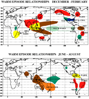
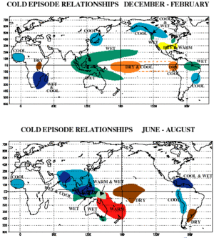
The El Niño–Southern Oscillation leads to changes in the atmospheric circulation patterns (also known as teleconnections).[38] Although the exact mechanisms are unknown, the impacts of the changes in atmospheric circulation patterns caused by the El Niño–Southern Oscillation are more clearly observed in the more humid eastern parts of the country (between Uruguay and southern Brazil).[38] During El Niño events, precipitation is more higher than normal while during La Niña events, precipitation is lower than normal in the Pampas.[39] In general, El Niño tends to increase precipitation during late spring and summer, particularly in the north.[40]:8 The impacts of La Niña in the eastern parts of the country (northeast and the Pampas) are observed in winter where precipitation is lower.[41]:5–6 In Northwest Argentina, El Niño events are associated with a strong reduction in rainfall during summer.[42] In contrast, La Niña events increase precipitation in northwest Argentina.[43] In the central–western parts of Patagonia, spring precipitation tends to be lower during La Niña events and higher during El Niño events.[16] Summer precipitation exhibits an opposite pattern where La Niña years involve wetter summers while El Niño years featuring drier summers.[16] On the Andes in central western Argentina, precipitation is higher during El Niño year.[41]:6
In general, La Niña events are associated with lower temperatures (particularly colder winters) in the Pampas.[41]:12 During winter, frosts are more common during La Niña events compared to El Niño events. This is due to a stronger southerly flow during La Niña events caused by a higher concentration of high pressure systems in the South Pacific and an increase in cyclonic activity (more low pressure systems) in the South Atlantic.[41]:12 This creates conditions that are favourable for bringing cold air from the south, particularly when there is a formation of a high pressure system over Patagonia (associated with the passage of a front) that is responsible for bringing cold air from the south.[41]:12 Thus, invasions of cold air from the south are more common during La Niña events.[41]:12 In contrast, warm spells in the Pampas and northern parts of the country are more intense and frequent during El Niño events.[31] This is due to stronger westerly winds south of 40oS, leading to less frequent incursions of cold air from the south while enhancing winds from the north that bring in warm air.[31] Although La Niña events lead to colder winters with more frequent incursions of cold air in both the north and central parts of the country, it leads to more frequent and intense warm spells in the last months of the year.[31][41]:13 In other regions, El Niño events lead to more frequent and intense warm spells in Northwest Argentina (during autumn), northeast Argentina (during spring) and central Argentina (during summer).[41]:13 Cold air anomalies arising from El Niño events are observed during spring and are the result of an increase in rainfall that lead to reductions in insolation.[25] For the southern parts of the country, El Niño events are associated with more intense and frequent cold spells during the coldest months.[31] In summer, El Niño events are associated with warmer summer temperatures in the southern parts of the country.[16]
Antarctic Oscillation
The Antarctic Oscillation, also known as the Southern Hemisphere Annular Mode is the main factor in tropospheric circulation variability south of 20oS and is characterized by pressure anomalies with one situated in the Antarctic and one situated in a band at around 40–50oS around the globe.[25] It mainly affects middle and high latitudes in the Southern Hemisphere.[44] It is characterized by the north–south displacement of the westerly wind belt that circle around Antarctica.[44] Such variation in the position of the westerly wind belt affects the intensity and position of cold fronts and mid latitude storm systems and is partly responsible for variation in precipitation in the southern parts of Argentina.[44][45] The Antarctic Oscillation is characterized by two phases: a positive and a negative phase.[44] A positive phase is when the westerly wind belt is displaced to the south.[44] The positive phase occurs when there is increased surface pressure over the southern parts of the South American continent and decreased pressure in Antarctica.[25][44] This results in stronger westerly winds in the southern parts of the country while preventing cold fronts from penetrating inland, producing more stable conditions.[44][45] Furthermore, the positive phase leads to warmer conditions south of 40oS, particularly during the summer in areas between 40–60oS.[25] Precipitation is lower due to less frontal and orographic precipitation resulting from reduced westerly wind flow between 40–60OS.[25] Opposite conditions occur in the negative phase when the westerly wind belt is shifted equatorward.[25][44] Cold fronts moving northwards from the south penetrate more frequently, leading to more precipitation and cooler temperatures during the negative phase.[44] The major effect of negative phase of the Antarctic Oscillation occurs in spring when it increases precipitation over southeastern South America.[44]
Indian Ocean Dipole
The Indian Ocean Dipole is an atmospheric–oceanic phenomenon characterized by differences in sea surface temperatures between the eastern and western sections of the tropical Indian Ocean.[46] Similar to the Antarctic Oscillation, the Indian Ocean Dipole is characterized by two phases: a positive and a negative phase.[47] In the positive phase, the eastern section of the tropical Indian Ocean is cooler (lower sea surface temperature) and the western section is warmer than normal (higher sea surface temperature).[47] On the other hand, the negative phase is characterized by warmer sea surface temperatures on the eastern section and cooler sea surface temperatures on the western section of the tropical Indian Ocean.[47] Studies have shown that the Indian Ocean Dipole is partly responsible for variations in precipitation in Argentina and South America in general.[47] During a positive phase, precipitation is higher in the Río de la Plata Basin due to teleconnections.[47]
Regional climate
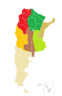
The vast size, and wide range of altitudes, contribute to Argentina's diverse climate.[48] Argentina possesses a wide variety of climatic regions ranging from subtropical in the north to subantarctic in the far south. Lying between those is the Pampas region, which features a mild and humid climate.[49][50] Consequently, there is a wide variety of biomes in the country, including subtropical rain forests, semi-arid and arid regions, temperate plains in the Pampas, and cold subantarctic in the south.[51] However, despite the diversity of biomes, about two-thirds of Argentina is arid or semi-arid.[51][14] In general, Argentina has four main climate types: warm, moderate, arid, and cold, all determined by the expanse across latitude, range in altitude, and relief features.[2] Argentina is best divided into six distinct regions reflecting the climatic conditions of the country as a whole.[52] From north to south, these regions are Northwest, Chaco, Northeast, Cuyo/Monte, Pampas, and Patagonia.[52][53] Each climatic region has distinctive types of vegetation.[54]
Mesopotamia
Mesopotamia[note 5] has a subtropical climate with no dry season.[2] Under the Köppen climate classification, it has a humid subtropical climate (Cfa).[55] The main features of the climate are high temperatures and abundant rainfall throughout the year;[2] this abundant rainfall makes water scarcity and extended periods of drought uncommon; most of the region has a positive water balance.[55][56][57]:85
Average annual precipitation ranges from less than 1,000 mm (39 in) in the southern parts of the Province to approximately 1,800 mm (71 in) in the eastern parts.[55][57]:30 Precipitation is slightly higher in the summer than in the winter and generally decreases from east to west and from north to south.[56][57]:32[58] Summer is the most humid season, ranging from a low of 300 mm (12 in) to a high of 450 mm (18 in).[57]:37 In this season, most rain falls during convective thunderstorms.[57]:38 Autumn is one of the rainiest seasons, with many places receiving over 350 mm (14 in).[57]:38 As in summer, precipitation falls mainly during convective thunderstorms.[57]:39 Winter is the driest season, with precipitation ranging from less than 40 mm (2 in) in the west to over 340 mm (13 in) in the east.[57]:39 Most of the precipitation during winter comes from frontal systems,[57]:40 particularly the sudestada (Spanish for strong southeasterly winds), bringing long periods of rain, cloudiness, cooler temperatures, and strong winds.[58][59][60][61] Spring is similar to autumn, with a mean precipitation of 340 mm (13 in).[57]:40
Summers are very hot and humid while winters are mild to warm.[62][55][58] The northern parts of the region are warmer than the southern parts.[58] During heat waves, temperatures can exceed 40 °C (104 °F) in the summer months, while in the winter months, cold air masses from the south can push temperatures below freezing, resulting in frost.[59][60][63] However, such cold fronts are brief and are less intense than areas further south or at higher altitudes.[59][60][63] Snowfall is extremely rare and mainly confined to the uplands of Misiones Province, where the last significant snowfall occurred in 1975 in Bernardo de Irigoyen.[63][64]
Chaco
The Chaco region[note 6] in the center-north has a subtropical climate with hot, humid summers and mild, dry winters.[58][66] Under the Köppen climate classification, the west has a semi-arid climate (Bs)[55] while the east has a humid subtropical climate (Cfa).[67][68]:486 Chaco is one of the few natural regions in the world located between tropical and temperate latitudes that is not a desert.[68]:486 Precipitation and temperature are relatively homogeneous throughout the region.[68]:486
Mean annual precipitation ranges from 1,200 mm (47 in) in the eastern parts of Formosa Province to a low of 450 to 500 mm (18 to 20 in) in the west and southwest.[55][57]:30 Summer witnesses the maximum precipitation.[55][58] Summer rains are intense, and torrential rain is common, occasionally causing floods and soil erosion.[67][69] During the winter months, precipitation is sparse.[55][58] Eastern areas receive more precipitation than western areas since they are more influenced by moist air from the Atlantic Ocean, which penetrates the eastern areas more than the west, bringing in more precipitation.[55] As a result, the vegetation differs: eastern areas are covered by forests, savannas, marshes and subtropical wet forest, and western areas are dominated by medium and low forests of mesophytic and xerophytic trees and a dense understory of shrubs and grasses.[51] In all parts of the region, precipitation is highly variable from year to year.[27]
The Chaco region is the hottest in Argentina, with a mean annual temperature of 23 °C (73 °F).[55] With mean summer temperatures occasionally reaching 28 °C (82 °F), the region has the hottest summers in the country.[55][57]:63 Winters are mild and brief, with mean temperatures in July ranging from 16 °C (61 °F) in the northern parts to 14 °C (57 °F) in the southernmost parts.[70]:1 Temperatures can reach as high has 49 °C (120 °F) in summer, and during cold waves can fall to −6 °C (21 °F).[55]
Northwest
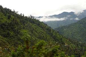
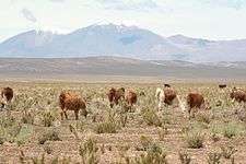
Northwest Argentina[note 4] is predominantly dry, hot, and subtropical.[71] Owing to its rugged and varied topography, the region is climatically diverse, depending on the altitude, temperature and distribution of precipitation.[72] Consequently, the vegetation will also differ.[73] Under the Köppen climate classification, the region has five different climate types: semi–arid (BS), arid (BW), temperate without a dry season and temperate with a dry season (Cf and CW respectively), and, at the highest altitudes, an alpine.[73]
Precipitation is highly seasonal and mostly concentrated in the summer months.[73][74] It is distributed irregularly due to the country's topography although it generally decreases from east to west.[73][75]:29 The eastern slopes of the mountains receives between 1,000 and 1,500 mm (39 and 59 in) of precipitation a year, though some places receive up to 2,500 mm (98 in) annually owing to orographic precipitation.[72][73] The high rainfall on these first slopes creates a thick jungle that extends in a narrow strip along these ranges.[76] The temperate valleys, the location of major cities such as Salta and Jujuy,[note 7] have an average precipitation ranging between 500 and 1,000 mm (20 and 39 in),[77] with rainfall mainly concentrated in the summer months, often falling in short but heavy bursts.[78][79] Valleys in the southern parts of the region are drier than those in the north due to the greater height of the Andes and the Sierras Pampeanas on the eastern slopes than the northern mountains, presenting a significant orographic barrier that blocks moist winds from the Atlantic and Pacific oceans.[75]:22–23[80]:28 These valleys receive less than 200 mm (8 in) of precipitation per year and are characterized by sparse vegetation adapted to the arid climate.[76] The area further west in the Puna region, with an average altitude of 3,900 m (12,800 ft), is mostly a desert due to the blocking of the easterly winds by the Andes and the northwest extension of the Sierras Pampeanas.[72][75]:33[76][81] Precipitation in the Puna region averages less than 200 mm (8 in) a year while high isolation, strong winds, and low humidity exacerbate the dry conditions.[51][82]
Temperatures in northwest Argentina vary by altitude.[72] The temperate valleys have a temperate climate, with mild summers and dry and cool winters with regular frosts.[78][83]:53In the Quebrada de Humahuaca valley, mean annual temperatures range from 12.0 to 14.1 °C (53.6 to 57.4 °F), depending on altitude.[84]:10 In the Calchaquí Valleys in Salta Province, the climate is temperate and arid with large thermal amplitudes, long summers, and a long frost-free period.[84]:10[85][86] In the valleys in the south in La Rioja Province, Catamarca Province and the southwest parts of Santiago del Estero Province, which is part of the arid Chaco ecoregion,[87] temperatures during the summer are very high, averaging 26 °C (79 °F) in January while winters are mild, averaging 12 °C (54 °F).[87] Cold fronts from the south bringing cold Antarctic air can cause severe frosts in the valleys of La Rioja Province and Catamarca Province.[80]:33 In contrast, the Zonda wind, which occurs more often during the winter months, can raise temperatures up to 35 °C (95 °F) with strong gusts, sometimes causing crop damage.[80]:33–34 Temperatures in the Puna region are much colder, with a mean annual temperature of less than 10 °C (50 °F) owing to the high altitude.[51] The Puna region is characterized by being cold with a large diurnal range but sunny throughout the year.[82][84]:17
Cuyo
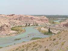
The Cuyo region[note 3] has an arid or a semi-arid climate.[88][89] The region's wide range in latitude, combined with altitudes ranging from 500 m (1,600 ft) to nearly 7,000 m (23,000 ft), means that it has a variety of different climate types.[86][89] In general, most of the region has a temperate climate, with valleys at higher altitudes having a milder climate.[85] At the highest altitudes (over 4,000 m (13,123 ft)), icy conditions persist year round.[89]
Average annual precipitation ranges from 100 to 500 mm (4 to 20 in), though it is generally unpredictable.[88][89] More than 85% of annual rainfall occurs from October to March, which constitutes the warm season.[88] In contrast, the winter months are dry.[36] Eastern and southeastern areas of the region receive more precipitation than the western areas since they receive more summer rainfall.[36] Precipitation is highly variable from year to year and appears to follow a cycle between dry and wet years in periods of about 2, 4–5, 6–8, and 16–22 years.[88] In wet years, easterly winds caused by the subtropical South Atlantic High are stronger, causing moisture to flow towards this region; during dry years, these winds are weaker.[88][36]
Summers in the region are hot and generally sunny; winters are dry and cold.[4][90] Since this region has a wide range of altitudes, ranging from 500 m (1,600 ft) to nearly 7,000 m (23,000 ft), temperatures can vary widely. The Sierras Pampeanas, which cross into both San Juan Province and San Luis Province, have a milder climate with mean annual temperatures ranging from 12 to 18 °C (54 to 64 °F).[91] Throughout the region, the diurnal range is great, with very high temperatures during the day followed by cold nights.[90] In all locations, at altitudes over 3,800 m (12,500 ft), permafrost is present; icy conditions persist year round at altitudes over 4,000 m (13,000 ft).[89]
The Zonda, a Foehn wind characterized by warm, dry air, can cause temperatures to exceed 30 °C (86 °F) and occasionally 45 °C (113 °F), as occurred in 2003.[92][93] However, cold waves are also common, caused by the channeling by the Andes of cold air from the south, making for frequent cold fronts during the winter months and bringing temperatures that can fall below freezing,[94][95] and occasionally below −10 to −30 °C (14 to −22 °F) at higher altitudes.[96]
Pampas
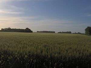
The Pampas[note 8] region has land that is appropriate for agriculture and raising livestock. It is a mostly flat area, interrupted only by the Tandil and Ventana sierras in its southern portion.[98] The climate of the Pampas is characterized as temperate and humid with no dry season, featuring hot summers and mild winters (Cfa/Cfb according to the Köppen climate classification).[98][99][100] The weather in the Pampas is variable due to the contrasting air masses and frontal storms that impact the region.[101] Annual temperatures range from 17 °C (63 °F) in the north to 14 °C (57 °F) in the south.[99] Precipitation increases toward the east[102] and ranges from under 500 mm (20 in) in the south and west to 1,200 mm (47 in) in the northeast.[103] Precipitation is fairly evenly distributed throughout the year in the easternmost parts of the Pampas; in the western parts, most of the precipitation is concentrated during the summer months, and winters are drier.[98][50] The Pampas are influenced by the El Niño Southern Oscillation, which is responsible for variation in annual precipitation.[98][103] An El Niño year leads to higher precipitation while a La Niña year leads to lower precipitation.[103]
Summers in the Pampas are hot and humid with coastal areas being modified by the cold Malvinas Current.[101] Afternoon thunderstorms, which can bring intense amounts of precipitation, are common, as are heat waves that can bring temperatures in the 36 to 40 °C (97 to 104 °F) range for a few days.[103] These thunderstorms are known to have the most frequent lightning and highest convective cloud tops in the world.[104][105] The severe thunderstorms produce intense hailstorms, floods, including flash floods, as well as the most consistently active tornado region outside the central and southeastern US.[106] These are usually followed a day or two of strong Pampero winds from the south, which bring cool, dry air.[103] Precipitation in the summer is high, with monthly amounts averaging between 90 mm (4 in) and 160 mm (6 in) in most places.[62][107]
Autumn arrives in March and brings periods of very rainy weather followed by dry, mild stretches and cool nights.[103] Some places in the east receive rainfall throughout autumn whereas in the west, after the rains, the weather quickly becomes very dry.[103] Generally, frost arrives in early April in the southernmost areas, in late May in the north, and ends by mid-September, although the dates of the first and last frosts can vary from year to year.[98][99][103] Frost is rarely intense or prolonged and may not occur each year.[4][64]
Winters are mild with frequent frosts and cold spells.[101] Temperatures are usually mild during the day and cold during the night.[100] Most precipitation results from frontal systems associated with cyclogenesis and sudestada, which bring long periods of precipitation, cloudiness and cooler temperatures, particularly in the southern and eastern parts.[64][108][61] Dull, gray and damp weather characterize winters in the Pampas.[64] Occasionally, tropical air masses from the north may move southward, providing relief from the cool, damp temperatures.[64] Snowfall is extremely rare. When it does snow, it usually lasts for only a day or two.[64]
Patagonia
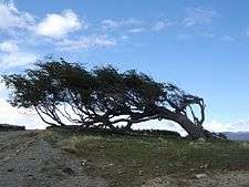
The Patagonian[note 2] climate is classified as arid to semi-arid and temperate to cool temperate.[111][16] One defining characteristic are the strong winds from the west which blow year round (stronger in summer than in winter), which favors evaporation and is a factor in making the region mostly arid.[17] There are three major factors that influence the climate of the region: the Andes, the South Pacific High and South Atlantic High, and an isolation that is more pronounced in eastern than western areas.[112]
The north–south orientation of the Andes creates a barrier for humid air masses coming from the Pacific Ocean, forming an extensive rain shadow and causing most of the region to be arid.[17][113] South of 52°S, the Andes are lower in elevation, reducing the rain shadow effect in Tierra del Fuego Province and allowing forests to thrive on the Atlantic coast.[110] Patagonia is located between the subtropical high pressure belt and the subpolar low pressure zone, meaning it is exposed to westerly winds that are strong, since south of 40°S there is little land to block these winds.[109][110] Because Patagonia is located between the semi-permanent anticyclones of the Pacific Ocean and the Atlantic Ocean at around 30°S, and the Subpolar Low at around 60°S, the movement of the high and low pressure systems along with ocean currents determine the precipitation pattern.[16]
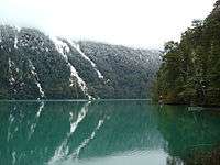
The influence of the Pacific Ocean, general circulation patterns, and the topographic barrier caused by the Andes results in one of the strongest precipitation gradients in the world.[16][15] Precipitation steeply decreases from west to east,[113][15] ranging from 4,000 mm (160 in) in the west on the Andean foothills at 41°S to 150 mm (6 in) in the central plateaus.[113] The high precipitation in the Andes in this region allows forests to thrive as well as glaciers and permanent snowfields.[4][102][114] Most of the region receives less than 200 mm (8 in) of precipitation per year.[17] The aridity of the region is due to the combination of low precipitation, strong winds, and high temperatures in the summer months, all of which cause high evaporation rates.[51] In most of Patagonia, precipitation is concentrated in the winter months, except for the northeastern and southern parts, where precipitation is more evenly distributed.[16][17][115] Thunderstorms are infrequent, occurring only during summer.[17] Snowfall occurs mainly in the west and south, which can result in strong snowstorms.[2][51]
Patagonia's temperatures are relatively cold for its latitude due to the cold Malvinas Current and the high altitude.[17] A characteristic of the temperature pattern is the NW–SE distribution of isotherms due to the presence of the Andes.[16] The warmest parts of the region are in northern parts of Rio Negro Province and Neuquén Province, where mean annual temperatures range from 13 to 15 °C (55 to 59 °F), while the coldest are in western Santa Cruz Province and Tierra del Fuego Province, where mean temperatures range from 5 to 8 °C (41 to 46 °F).[17] At higher altitudes in the Andes stretching from Neuquén Province to Tierra del Fuego Province, mean annual temperatures are below 5 °C (41 °F).[17] Strong westerly winds can decrease the perception of temperature (wind chill), particularly in summer.[16] The annual range of temperatures in Patagonia is lower than at similar latitudes in the northern hemisphere owing to the narrowness of the region at higher latitudes and the stronger maritime influence.[16][116]
Statistics
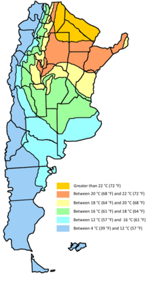
The average annual precipitation ranges from 150 millimetres (6 in) in the driest parts of Patagonia to over 2,000 millimetres (79 in) in the westernmost parts of Patagonia and the northeastern parts of the country.[50] Mean annual temperatures range from 5 °C (41 °F) in the far south to 25 °C (77 °F) in the north.[50] Shown below are the mean monthly temperature and precipitation for selected places in Argentina along with the overall averages for the country (based on a 0.5o latitude/longitude grid).[117] Year-round averages and totals are displayed along with conversions to imperial units.
Temperature
| Location | Jan | Feb | Mar | Apr | May | Jun | Jul | Aug | Sept | Oct | Nov | Dec | Annual |
|---|---|---|---|---|---|---|---|---|---|---|---|---|---|
| Salta[118] | 0821.2 (70.2) | 08 20.1 (68.2) | 08 18.9 (66.0) | 09 16.2 (61.2) | 11 13.3 (55.9) | 11 10.1 (50.2) | 11 10.1 (50.2) | 11 12.3 (54.1) | 12 15.0 (59.0) | 11 18.7 (65.7) | 10 20.3 (68.5) | 08 21.2 (70.2) | 09 16.5 (61.7) |
| La Quiaca[119] | 0212.5 (54.5) | 02 12.1 (53.8) | 04 12.0 (53.6) | 04 10.2 (50.4) | 04 6.7 (44.1) | 04 4.1 (39.4) | 05 3.8 (38.8) | 05 6.0 (42.8) | 05 8.7 (47.7) | 04 10.7 (51.3) | 04 12.0 (53.6) | 02 12.2 (54.0) | 04 9.2 (48.6) |
| La Rioja[120] | 1727.4 (81.3) | 16 25.9 (78.6) | 15 23.4 (74.1) | 14 19.8 (67.6) | 14 15.5 (59.9) | 12 11.1 (52.0) | 12 10.9 (51.6) | 14 14.0 (57.2) | 15 17.8 (64.0) | 16 22.5 (72.5) | 17 25.4 (77.7) | 17 27.2 (81.0) | 14 20.1 (68.2) |
| Santiago del Estero[121] | 1426.8 (80.2) | 14 25.6 (78.1) | 14 23.4 (74.1) | 15 20.0 (68.0) | 15 16.7 (62.1) | 15 12.7 (54.9) | 15 12.6 (54.7) | 15 15.0 (59.0) | 16 18.4 (65.1) | 15 22.3 (72.1) | 16 24.7 (76.5) | 15 26.5 (79.7) | 16 20.4 (68.7) |
| Formosa[122] | 1627.3 (81.1) | 17 26.8 (80.2) | 17 25.2 (77.4) | 17 22.0 (71.6) | 17 19.3 (66.7) | 17 16.7 (62.1) | 17 16.8 (62.2) | 17 17.7 (63.9) | 17 19.5 (67.1) | 17 22.6 (72.7) | 15 24.5 (76.1) | 16 26.5 (79.7) | 17 22.1 (71.8) |
| Oberá[123] | 1325.4 (77.7) | 13 24.5 (76.1) | 16 23.6 (74.5) | 16 20.2 (68.4) | 16 17.4 (63.3) | 16 14.9 (58.8) | 16 15.2 (59.4) | 16 16.7 (62.1) | 14 17.4 (63.3) | 14 20.8 (69.4) | 13 22.8 (73.0) | 13 24.8 (76.6) | 15 20.3 (68.5) |
| San Juan[124] | 1527.0 (80.6) | 15 25.7 (78.3) | 13 22.4 (72.3) | 11 17.5 (63.5) | 09 12.2 (54.0) | 08 7.8 (46.0) | 08 7.8 (46.0) | 09 10.8 (51.4) | 09 14.0 (57.2) | 13 19.7 (67.5) | 14 23.5 (74.3) | 14 26.4 (79.5) | 12 17.9 (64.2) |
| San Luis[125] | 1124.4 (75.9) | 10 23.1 (73.6) | 10 20.2 (68.4) | 10 16.7 (62.1) | 10 13.2 (55.8) | 10 9.6 (49.3) | 10 9.4 (48.9) | 10 11.6 (52.9) | 11 14.5 (58.1) | 10 18.4 (65.1) | 12 21.4 (70.5) | 12 23.6 (74.5) | 10 17.2 (63.0) |
| Malargüe[126] | 0619.6 (67.3) | 06 18.4 (65.1) | 05 15.3 (59.5) | 05 11.3 (52.3) | 05 7.4 (45.3) | 05 4.2 (39.6) | 04 3.5 (38.3) | 04 5.4 (41.7) | 04 8.1 (46.6) | 05 12.1 (53.8) | 05 15.6 (60.1) | 06 18.4 (65.1) | 05 11.6 (52.9) |
| Puente del Inca[127] | 0214.2 (57.6) | 03 13.8 (56.8) | 03 11.7 (53.1) | 03 8.4 (47.1) | 02 4.2 (39.6) | 01 0.9 (33.6) | 01 -0.1 (31.8) | 01 1.2 (34.2) | 01 4.0 (39.2) | 02 6.6 (43.9) | 02 10.1 (50.2) | 03 13.1 (55.6) | 02 7.4 (45.3) |
| Buenos Aires[128] | 1224.5 (76.1) | 12 23.4 (74.1) | 12 21.3 (70.3) | 12 17.6 (63.7) | 12 14.4 (57.9) | 13 11.2 (52.2) | 13 11.0 (51.8) | 11 12.3 (54.1) | 10 14.4 (57.9) | 09 17.2 (63.0) | 09 20.3 (68.5) | 10 23.0 (73.4) | 11 17.5 (63.5) |
| Córdoba, Argentina[129] | 1024.1 (75.4) | 11 23.1 (73.6) | 11 20.9 (69.6) | 13 17.9 (64.2) | 13 14.9 (58.8) | 14 11.3 (52.3) | 14 11.3 (52.3) | 12 13.2 (55.8) | 13 15.6 (60.1) | 12 18.9 (66.0) | 11 21.3 (70.3) | 11 23.2 (73.8) | 13 18.0 (64.4) |
| Santa Rosa[130] | 0923.7 (74.7) | 09 22.4 (72.3) | 09 19.1 (66.4) | 07 15.1 (59.2) | 07 11.2 (52.2) | 07 7.8 (46.0) | 07 7.6 (45.7) | 08 9.3 (48.7) | 08 12.2 (54.0) | 08 15.6 (60.1) | 08 19.3 (66.7) | 09 22.4 (72.3) | 08 15.5 (59.9) |
| Mar del Plata[131] | 0720.3 (68.5) | 07 19.9 (67.8) | 07 18.0 (64.4) | 06 14.6 (58.3) | 08 11.3 (52.3) | 09 8.5 (47.3) | 09 8.1 (46.6) | 07 8.9 (48.0) | 07 10.5 (50.9) | 07 13.1 (55.6) | 07 15.9 (60.6) | 07 18.5 (65.3) | 07 14.0 (57.2) |
| Bariloche[132] | 03 14.4 (57.9) | 04 14.0 (57.2) | 02 11.5 (52.7) | 02 7.7 (45.9) | 03 5.2 (41.4) | 03 2.7 (36.9) | 03 2.2 (36.0) | 03 2.9 (37.2) | 03 4.7 (40.5) | 03 7.6 (45.7) | 03 10.7 (51.3) | 04 13.1 (55.6) | 03 8.1 (46.6) |
| Comodoro Rivadavia[133] | 05 19.1 (66.4) | 05 18.4 (65.1) | 06 16.1 (61.0) | 05 12.9 (55.2) | 06 9.5 (49.1) | 06 6.8 (44.2) | 06 6.4 (43.5) | 06 7.7 (45.9) | 06 9.9 (49.8) | 06 12.7 (54.9) | 06 15.9 (60.6) | 05 17.9 (64.2) | 06 12.8 (55.0) |
| Ushuaia[134] | 01 10.3 (50.5) | 01 9.5 (49.1) | 01 7.6 (45.7) | 01 5.7 (42.3) | 01 3.1 (37.6) | 02 1.7 (35.1) | 02 1.6 (34.9) | 02 2.4 (36.3) | 02 4.3 (39.7) | 01 6.5 (43.7) | 01 8.3 (46.9) | 01 9.1 (48.4) | 01 5.8 (42.4) |
Precipitation
.gif)
| Jan | Feb | Mar | Apr | May | Jun | Jul | Aug | Sept | Oct | Nov | Dec | Annual | |
|---|---|---|---|---|---|---|---|---|---|---|---|---|---|
| Salta[118] | 182.0 (7.17) | 162.9 (6.41) | 118.3 (4.66) | 36.6 (1.44) | 8.6 (0.34) | 2.6 (0.10) | 3.5 (0.14) | 4.2 (0.17) | 6.6 (0.26) | 26.1 (1.03) | 65.3 (2.57) | 138.0 (5.43) | 754.7 (29.71) |
| La Quiaca[119] | 79.7 (3.14) | 68.0 (2.68) | 48.7 (1.92) | 9.7 (0.38) | 0.7 (0.03) | 0.7 (0.03) | 0.0 (0.00) | 0.7 (0.03) | 2.7 (0.11) | 16.3 (0.64) | 30.0 (1.18) | 78.0 (3.07) | 335.0 (13.19) |
| La Rioja[120] | 80.1 (3.15) | 71.6 (2.82) | 54.1 (2.13) | 18.4 (0.72) | 7.4 (0.29) | 2.6 (0.10) | 3.1 (0.12) | 5.2 (0.21) | 6.5 (0.26) | 12.7 (0.50) | 43.3 (1.71) | 56.6 (2.23) | 361.6 (14.24) |
| Santiago del Estero[121] | 135.5 (5.34) | 111.3 (4.38) | 83.3 (3.28) | 37.2 (1.47) | 16.7 (0.66) | 6.2 (0.24) | 3.7 (0.15) | 4.5 (0.178) | 13.8 (0.54) | 33.2 (1.31) | 67.6 (2.66) | 96.1 (3.78) | 609.1 (23.98) |
| Formosa[122] | 171.2 (6.74) | 142.4 (5.61) | 151.7 (5.97) | 153.3 (6.04) | 105.6 (4.16) | 66.8 (2.63) | 49.6 (1.95) | 60.1 (2.37) | 85.1 (3.35) | 120.7 (4.75) | 171.0 (6.73) | 146.8 (5.78) | 1424.3 (56.08) |
| Oberá[123] | 181.8 (7.16) | 215.6 (8.49) | 158.6 (6.24) | 235.1 (9.26) | 252.0 (9.92) | 163.9 (6.45) | 138.8 (5.47) | 175.8 (6.92) | 153.7 (6.05) | 179.2 (7.06) | 217.3 (8.56) | 230.6 (9.08) | 2302.4 (90.65) |
| San Juan[124] | 15.3 (0.60) | 18.4 (0.72) | 11.4 (0.45) | 1.9 (0.08) | 4.6 (0.18) | 1.3 (0.05) | 7.2 (0.28) | 3.0 (0.12) | 7.0 (0.28) | 4.7 (0.19) | 5.9 (0.23) | 11.6 (0.46) | 92.3 (3.63) |
| San Luis[125] | 109.7 (4.32) | 86.9 (3.42) | 91.2 (3.59) | 42.2 (1.66) | 11.6 (0.46) | 8.9 (0.35) | 10.8 (0.43) | 8.1 (0.32) | 19.2 (0.76) | 35.9 (1.41) | 77.4 (3.05) | 101.3 (3.99) | 603.2 (23.75) |
| Malargüe[126] | 24.0 (0.95) | 29.5 (1.16) | 24.5 (0.97) | 14.5 (0.57) | 21.1 (0.83) | 35.0 (1.38) | 36.9 (1.45) | 16.1 (0.63) | 21.1 (0.83) | 19.4 (0.76) | 22.1 (0.87) | 26.6 (1.05) | 290.8 (11.45) |
| Puente del Inca[127] | 4.9 (0.19) | 5.8 (0.23) | 4.2 (0.17) | 10.5 (0.41) | 68.5 (2.70) | 64.9 (2.56) | 49.6 (1.95) | 47.9 (1.89) | 16.6 (0.65) | 18.1 (0.71) | 10.9 (0.43) | 1.2 (0.05) | 302.8 (11.92) |
| Buenos Aires[128] | 119.0 (4.69) | 117.6 (4.63) | 134.1 (5.28) | 97.0 (3.82) | 73.6 (2.90) | 62.6 (2.47) | 66.3 (2.61) | 69.8 (2.75) | 73.3 (2.89) | 119.0 (4.69) | 108.6 (4.28) | 105.0 (4.13) | 1145.9 (45.11) |
| Córdoba [129] | 121.7 (4.79) | 99.8 (3.93) | 110.3 (4.34) | 52.2 (2.06) | 18.9 (0.74) | 11.4 (0.45) | 12.8 (0.50) | 9.7 (0.38) | 33.8 (1.33) | 66.4 (2.61) | 96.6 (3.80) | 136.9 (5.39) | 770.5 (30.34) |
| Santa Rosa[130] | 74.1 (2.92) | 74.8 (2.95) | 91.7 (3.61) | 52.7 (2.08) | 27.7 (1.09) | 16.3 (0.64) | 18.7 (0.74) | 23.3 (0.92) | 41.8 (1.65) | 70.2 (2.76) | 101.0 (3.98) | 93.5 (3.68) | 685.8 (27.00) |
| Mar del Plata[131] | 100.1 (3.94) | 72.8 (2.87) | 107.0 (4.21) | 73.3 (2.89) | 73.5 (2.89) | 54.9 (2.16) | 58.9 (2.32) | 64.0 (2.52) | 56.4 (2.22) | 83.4 (32.8) | 75.3 (2.97) | 104.0 (4.09) | 923.6 (36.36) |
| Bariloche[132] | 24.3 (0.96) | 19.7 (0.78) | 28.6 (1.13) | 52.8 (2.08) | 130.5 (5.14) | 126.9 (5.00) | 140.2 (5.52) | 115.3 (4.54) | 56.1 (2.21) | 34.7 (1.37) | 23.1 (0.91) | 30.4 (1.20) | 782.6 (30.81) |
| Comodoro Rivadavia[133] | 16.2 (0.64) | 15.0 (0.59) | 20.7 (0.82) | 23.3 (0.92) | 31.7 (1.25) | 25.3 (1.00) | 28.7 (1.13) | 25.0 (0.98) | 12.3 (0.48) | 14.9 (0.59) | 10.6 (0.42) | 15.0 (0.59) | 238.7 (9.40) |
| Ushuaia[134] | 30.7 (1.21) | 33.2 (1.31) | 47.8 (1.88) | 49.7 (1.96) | 54.5 (2.15) | 54.7 (2.15) | 46.2 (1.82) | 60.7 (2.39) | 39.5 (1.56) | 34.6 (1.36) | 35.4 (1.39) | 41.0 (1.61) | 528.0 (20.79) |
Overall averages
| Climate data for Argentina (country–wide averages)[117] 1961–1990 | |||||||||||||
|---|---|---|---|---|---|---|---|---|---|---|---|---|---|
| Month | Jan | Feb | Mar | Apr | May | Jun | Jul | Aug | Sep | Oct | Nov | Dec | Year |
| Average high °C (°F) | 28.4 (83.1) |
27.4 (81.3) |
24.7 (76.5) |
21.0 (69.8) |
17.2 (63) |
13.9 (57) |
14.0 (57.2) |
16.3 (61.3) |
19.0 (66.2) |
22.2 (72) |
25.2 (77.4) |
27.5 (81.5) |
21.4 (70.5) |
| Daily mean °C (°F) | 21.4 (70.5) |
20.5 (68.9) |
18.1 (64.6) |
14.6 (58.3) |
11.2 (52.2) |
8.2 (46.8) |
8.0 (46.4) |
9.6 (49.3) |
12.1 (53.8) |
15.3 (59.5) |
18.1 (64.6) |
20.4 (68.7) |
14.8 (58.6) |
| Average low °C (°F) | 14.4 (57.9) |
13.7 (56.7) |
11.6 (52.9) |
8.3 (46.9) |
5.3 (41.5) |
2.6 (36.7) |
2.0 (35.6) |
3.0 (37.4) |
5.3 (41.5) |
8.4 (47.1) |
11.1 (52) |
13.4 (56.1) |
8.3 (46.9) |
| Average precipitation mm (inches) | 74 (2.91) |
68 (2.68) |
74 (2.91) |
50 (1.97) |
37 (1.46) |
28 (1.1) |
26 (1.02) |
24 (0.94) |
32 (1.26) |
51 (2.01) |
59 (2.32) |
67 (2.64) |
590 (23.23) |
| Average precipitation days | 8.1 | 7.3 | 7.4 | 5.9 | 5.3 | 4.9 | 4.8 | 4.3 | 4.7 | 6.2 | 6.8 | 8.0 | 73.7 |
| Source: Climate Research Unit[135] | |||||||||||||
Extremes
High
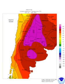
In general, the highest temperatures in Argentina are recorded in the northern Chaco region where temperatures of 45 to 50 °C (113 to 122 °F) have been recorded.[137]:15 According to the World Meteorological Organization, the highest temperature ever recorded in Argentina and South America was 48.9 °C (120.0 °F) in Rivadavia, Salta Province on December 11, 1905.[138]
Low
Patagonia and the Puna region register the lowest temperatures in Argentina where temperatures lower than −20 °C (−4 °F) have been recorded.[137] The lowest temperature ever recorded in Argentina and South America was −32.8 °C (−27.0 °F) in Sarmiento, Chubut Province on June 1, 1907.[138] This was recorded under standard conditions.[139]
Precipitation
With an average annual precipitation of 3,668 mm (144.4 in), Lago Frías in Río Negro Province is considered to be the wettest place in Argentina.[140] Although an average annual precipitation of 6,251 mm (246.1 in) has been recorded in Lago Tromen in Neuquén Province, the validity of the data is dubious owing to fewer years of data.[140] Lago Frías also has the record for wettest monthly precipitation in Argentina: 1,147 mm (45.2 in) of precipitation was recorded in May 1951.[136] In contrast, the driest place is Angualasto, San Juan Province, which only receives 24 mm (0.94 in) of precipitation a year.[140] The highest recorded one-day rainfall total occurred on April 2, 2013, when 392.2 mm (15.44 in) of rain fell in La Plata at the La Plata Astronomical Observatory,[141] causing massive flooding and power outages.[142]
Natural disasters
Floods
Argentina's geomorphic characteristics make the country highly vulnerable to floods.[143] These floods can damage infrastructure, cause loss of life, increase the risk of diseases, and negatively impact agricultural productivity, which is one of the main economic activities of the country.[144][145] Many of the large Argentinean cities and agriculturally productive areas lie near rivers.[143] The plains are at highest risk for flooding, particularly in the northeastern and central parts of the country, including Greater Buenos Aires.[144] This is because these plains, which cover 35% of the land area in the country (including the Chaco and Pampean areas), are characterized by a flat landscape, which can impede proper water drainage.[146] Both the Parana and Paraguay basins have a flat landscape and are thus highly susceptible to flooding due to river overflows following high rainfall.[14] These floods can last for months, particularly in the Parana River, owing to its large basin.[14] In the most extreme case, during the year 1982–1983, the floods in the Parana River persisted for more than a year, negatively impacting the area both socially and economically.[147] Major flooding events in the Parana River include those of 1992 and 1997 and have been more frequent since the 1980s due to higher precipitation trends.[14] Similarly, in Buenos Aires Province, flooding occurs due to river overflows and poor water drainage; major flooding events in the province occurred in 1987, 2002/2003, 2012 and in 2014, causing damage to agriculture production.[14] Most of the flooding events occur in El Niño years owing to higher rainfall.[148]:38 Flooding can also affect Patagonia and urban centers in the northwest, but the number of people affected and economic losses are lower than those in the Pampas owing to lower population densities.[149] Flooding can jeopardize access to safe water.[150] A leptospirosis outbreak occurred following a flood in 1998.[150]
Droughts and dust storms
Argentina is highly dependent on water supplies originating outside its borders, making it highly vulnerable to changes in water supply due to climate change.[151] Droughts are frequent and devastating.[152] Several years of droughts during the last decade have severely affected agricultural production and reduced economic growth.[151][153] A drought in 2009 was the worst drought in more than 50 years.[154] Many cattle died of hunger, and huge swaths of soy, corn and wheat fields were affected.[154] It was estimated that the country lost more than US$5 billion from the drought.[154] A drought in 2011 affected farming of soy and corn, causing losses of US$2.5 billion.[148]
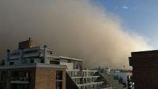
Drier parts of the country are highly prone to dust storms.[155] These include areas west of Buenos Aires, which can average more than eight dust storms per year, and parts of Patagonia, owing to its aridity and windy climate.[156] Certain areas in the Altiplano are also highly prone to dust storms owing to extensive areas of closed depressions and the presence of salt flats that erode the rock, which becomes a source of fine material that can travel large distances during periods of strong wind.[155][156] Dust storms are more frequent during droughts, particularly in agricultural areas.[155] Dust storms can effect large areas, leading to numerous impacts.[157] These dust storms can lead to loss of crop and livestock, affecting the local economy.[157] Productive topsoil may be lost during dust storms, leading to loss in soil productivity, which can increase soil erosion and negatively affect crop productivity in the long term.[157] In addition to the impact on agriculture, dust storms can damage cars and buildings, lower visibility on roads, affect air quality, and affect water quality in rivers and lakes.[157]
Tornados and severe storms

Argentina experiences frequent tornados each year.[158] Tornados occur in the South American "tornado alley"[106] (Spanish: Pasillo de los Tornados), which includes the provinces of Entre Ríos, Córdoba Province, Santa Fe, La Pampa and Greater Buenos Aires.[159] The frequency of tornadoes is similar to the one found in Tornado Alley in North America.[160] However, there is no exact number of tornado occurrences per year, owing to the lack of data.[160][161] These regions have the most frequent and intense mesoscale convective systems.[106] Tornados occur between November and April.[161] In this region, which occupies most of the Pampas, cold air from Patagonia meets warm, humid air from Brazil with dry air coming from the Andes.[161] When these air masses collide, they can produce intense storms, frequently becoming supercells that can produce tornados.[161] With a larger number of convective storms, there is a higher chance that some of these storms will produce tornados.[158] Most tornados are relatively weak and rarely cause deaths.[159] The strongest tornado recorded in Argentina occurred in 1973 when a tornado struck San Justo, Santa Fe.[161] The tornado was an F5 on the Fujita scale, with winds up to 500 km/h (310 mph), making it the worst tornado in Latin America and the Caribbean.[161]
Severe storms impact large cities more often and can damage cars, houses and disrupt public services such as transportation and collection and disposal of urban solid waste.[148]:39 The foothills of the Andes and the Sierras de Cordoba are vulnerable to hail.[106] This is because the Andes force humid air from the Atlantic upwards,[162] intensifying the updrafts within thunderstorms, making hail more likely.[163] Mendoza, a city located in the Andean foothills, experiences frequent hailstorms that can impact the agriculture of the region.[106] Hailstorms have caused serious losses in both urban and rural areas.[162] It is estimated that wine and fruit production experience yearly losses of US$50 million and US$30 million, respectively, due to hail.[162] Most of these hailstorms occur in the summer although they can occur in winter, particularly in the east where warm and humid air from the north frequently collides with cold air from the south, leading to convective thunderstorms that can produce hail.[162]
Storm surges caused by extratropical cyclones have been recorded along the coastal areas.[164] These storm surges are formed from strong winds that blow towards the land.[165] They are formed due to the interaction between the semi-permanent South Pacific High and a low pressure system over the Atlantic, southeast of Argentina, creating strong winds from the south or southwest.[164] The sudestada, which brings the worst storm surges, occurs when there is a high pressure system over southern Argentina in the Atlantic Ocean that interacts with a low pressure over Uruguay and southern Brazil, causing strong winds from the southeast.[61][166] Storm surges have caused flooding of coastal areas, leading to extensive property loss and other damage.[166][167] It is also the main natural factor in the erosion of coastlines.[167] The flooding as a result of storm surges are particularly destructive in flat coastal areas such as the Rio de La Plata shores, and the Salado Basin.[166]
Snowstorms and cold waves
Argentina regularly receives cold air from the south that can reach low latitudes owing to the influence of the Andes.[168] Cold waves are usually accompanied with severe snowstorms or extremely cold conditions that can have a devastating impact on the country's economy.[168] These snowstorms and/or extremely cold conditions can partially or completely paralyze activities in large areas of Patagonia and the center of the country.[62]:12 In addition, cold conditions can lead to energy shortages during the winter months due to increased demand.[168] The low temperatures brought by these cold waves can cause frosts that can damage plants, severely affecting agricultural production and devastating the local economy.[169]
Climate change
According to the national government and scientists, climate change is predicted to have a significant effect on the climate of Argentina.[170]:30 There has been an increase in annual precipitation in almost all of Argentina during the 20th century, particularly in the northeast and the center of the country, where agricultural production has expanded to the west by more than 100 km (62 mi) in areas that were previously too dry during middle of the 20th century.[62]:24[171]:86–88 In contrast, the Andean part of Patagonia, along with the Cuyo region, has seen a decrease in precipitation, leading to a reduction in river flow in the last 100 years.[172]:15 These trends were observed with an increase in the river–stream flows in most of the country, excluding rivers originating from the Andes, and an increase in extreme precipitation events that led to considerable socioeconomic losses.[171]:25,87 The increase in precipitation has led to more variability in precipitation from year to year in the northern parts of the country, with a higher risk of prolonged droughts.[171]:88
Mean temperatures have increased by 0.5 °C (0.9 °F) between 1901 and 2012, slightly lower than the global average.[14] Temperatures in the Andean part of Patagonia have increased by more than 1 °C (1.8 °F), which has caused the retreat of almost all of the glaciers.[170]:30[171]:25 This is affecting water availability to the arid areas of the country that depend on glacier meltwater.[173] Higher temperatures can reduce winter snowfall, causing river flow to decrease, which in turn can reduce hydroelectric energy production; losses of up to 40% have been observed.[171]:25 In the last half of the 20th century, the lack of snow in the highest peaks in the Cuyo region has impacted agriculture and viticulture production due to the decrease in available water in the rivers.[174] Outside of Patagonia, mean temperatures have increased at a slower rate since the increase in minimum temperatures is counteracted by the decrease in maximum temperatures.[171]:89 There has been a decrease in the number of days with frost, and there have been increases in the frequency of hot nights and heat waves throughout the country.[14][172]:11
Within the next two or three decades (2016–2035), mean temperatures are predicted to increase by 0.5 to 1.0 °C (0.9 to 1.8 °F) under the two scenarios (RCP 4.5 and RCP 8.5) from the IPCC Fifth Assessment Report.[14] In both scenarios, the projected warming will be more pronounced during the summer months.[14] The predicted trend for precipitation is not as clear as the one for temperature.[171]:92 In the northern and central regions, precipitation is predicted to increase while in most of central–western Argentina and Patagonia, precipitation is predicted to decrease.[14] Because Argentina is potentially vulnerable to climate change, such projected changes based on the models could exacerbate current problems or create new problems associated with climate change in Argentina.[171]:25
Scientists predict that glaciers will continue to recede and melt or, in some areas, disappear.[14] It is also predicted that the Cuyo region could face a potential water crisis due to an increase in water demand caused by a reduction in river streamflows.[14][171]:95 In northern Patagonia, a similar situation is projected in which there will be a negative impact on fruit and vegetable growing owing to a reduction in the river flow in the Colorado and Chubut rivers.[14][171]:97 In the north and central parts of the country, the higher temperatures and lower precipitation projected for this region will lead to higher evaporation, intensifying droughts and leading to desertification.[171]:94 Heat waves could become more frequent and intense, negatively impacting agricultural production while placing more demand on energy needs.[171]:94[174] Intense precipitation could become more common, increasing the likelihood of suffering from events such as flooding, since most of its population lives in urban areas near a body of water (rivers, lakes and oceans).[171]:33,95 Climate change could extend the habitats of vectors carrying tropical diseases such as malaria southwards.[175] Though most of the coastal regions of Argentina will not suffer permanent flooding associated with sea level rise, it is predicted that storm surges will become more frequent in coastal areas, affecting locations such as Buenos Aires.[14][62]:67[171]:98
See also
- Agriculture in Argentina
- Climate of Buenos Aires
- Geography of Argentina
- Geographical regions of Argentina
- Environment of Argentina
- Glaciers of Argentina
Notes
- 1 2 Argentina claims sovereignty over part of Antarctica and the Falkland Islands. However, territorial claims in Antarctica are suspended by the Antarctic Treaty while the United Kingdom exercises de facto control of the Falkland Islands
- 1 2 Chubut Province, Neuquén Province, Río Negro Province, Santa Cruz Province, and Tierra del Fuego Province are the provinces that make up Patagonia.[6] It also includes a small portion in the southern parts of Buenos Aires Province in Patagones Partido, La Pampa Province and Mendoza Province.[7]
- 1 2 Cuyo includes the provinces of Mendoza, San Juan and San Luis.[6]
- 1 2 Northwest Argentina consists of Catamarca Province, Jujuy Province, La Rioja Province, western parts of Salta Province, and Tucumán Province.[6] Although Santiago del Estero Province is part of northwest Argentina, most of the province lies in the Chaco region.[12]
- ↑ Mesopotamia includes the provinces of Misiones, Entre Ríos and Corrientes[55]
- ↑ The provinces of Chaco, Formosa Province lie completely within the region[65] including most of Santiago del Estero Province lies mostly or completely within the Chaco region.[12] It also includes eastern parts of Jujuy Province, Salta Province and Tucumán Province, and northern parts of Córdoba Province and Santa Fe Province.[65]
- ↑ According to INTA, the temperate valleys include the Lerma Valley, Siancas Valley in Salta Province and the Pericos Valley and the temperate valleys of Jujuy, which includes the two provincial capitals
- ↑ The Pampas includes all of Buenos Aires Province, eastern and southern Córdoba Province, eastern La Pampa Province, and southern Santa Fe Province.[97]
References
- ↑ "Geografía y Clima de la Argentina" (in Spanish). Government of Argentina. Retrieved 28 August 2015.
- 1 2 3 4 5 6 "Geography and Climate of Argentina". Government of Argentina. Archived from the original on 20 December 2010. Retrieved 28 August 2015.
- 1 2 3 4 5 6 7 "Argentine Republic". Country Nuclear Power Profiles. International Atomic Energy Agency. Retrieved 8 August 2016.
- 1 2 3 4 5 "Argentina". BBC Weather. Retrieved 7 June 2015.
- 1 2 "Valores Estadisticos del trimester (Junio–Augusto)" (PDF). Boletín de Tendencias Climáticas–Junio 2012 (in Spanish). Servicio Meteorológico Nacional. Retrieved 8 July 2015.
- 1 2 3 4 5 6 "Valores Estadisticos del trimester (Diciembre–Febrero)". Boletín de Tendencias Climáticas–Diciembre 2011 (in Spanish). Servicio Meteorológico Nacional. Retrieved 8 July 2015.
- ↑ "Region de la Patagonia" (PDF) (in Spanish). Ministerio del Interior, Obras Públicas y Vivienda. Retrieved 8 February 2016.
- 1 2 "Valores Estadisticos del trimester (Septiembre–Noviembre)" (PDF). Boletín de Tendencias Climáticas–Septiembre 2012 (in Spanish). Servicio Meteorológico Nacional. Retrieved 8 July 2015.
- 1 2 3 4 "Valores Estadisticos del trimester (Diciembre–Febrero)" (PDF). Boletín de Tendencias Climáticas–Diciembre 2014 (in Spanish). Servicio Meteorológico Nacional. Retrieved 8 July 2015.
- 1 2 3 4 "Valores Estadisticos del trimester (Marzo–Mayo)" (PDF). Boletín de Tendencias Climáticas–Marzo 2014 (in Spanish). Servicio Meteorológico Nacional. Retrieved 8 July 2015.
- 1 2 3 "Valores Estadisticos del trimester (Marzo–Mayo)" (PDF). Boletín de Tendencias Climáticas–Marzo 2009 (in Spanish). Servicio Meteorológico Nacional. Retrieved 8 July 2015.
- 1 2 "Santiago del Estero: Descripción". Atlas Climático Región Noroeste (in Spanish). Retrieved 7 February 2016.
- 1 2 3 4 5 6 7 Bianchi, Alberto; Cravero, Silvia. "Atlas Climático Digital de la República Argentina" (PDF) (in Spanish). Instituto Nacional de Tecnología Agropecuaria.
- 1 2 3 4 5 6 7 8 9 10 11 12 13 14 15 16 17 18 19 20 21 22 23 Barros, Vicente; Boninsegna, José; Camilloni, Inés; Chidiak, Martina; Magrín, Graciela; Rusticucci, Matilde (2014). "Climate change in Argentina: trends, projections, impacts and adaptation". Wiley Interdisciplinary Reviews: Climate Change. John Wiley & Sons. 6 (2): 151–169. doi:10.1002/wcc.316. Retrieved 28 August 2015.
- 1 2 3 4 5 6 Manzini 2008, p. 351.
- 1 2 3 4 5 6 7 8 9 10 11 12 13 14 Paruelo, José; Beltrán, Adriana; Jobbágy, Esteban; Sala, Osvaldo; Golluscio, Roberto (1998). "The Climate of Patagonia: general patterns and controls on biotic processes" (PDF). Ecologia Austral. 8: 85–101. Retrieved 11 August 2015.
- 1 2 3 4 5 6 7 8 9 10 11 12 "Patagonia–Clima Y Metéorologia" (in Spanish). Secretaria de Mineria de la Nacion (Argentina). Archived from the original on 30 August 2015. Retrieved 13 August 2015.
- ↑ "Mar Argentino" (in Spanish). Ministerio de Ambiente y Desarrollo Sustentable de la Nación. Retrieved 5 May 2016.
- 1 2 Siedler 2013, p. 316.
- ↑ Latrubesse 2009, p. 4.
- ↑ Latrubesse 2009, p. 5.
- ↑ Moore 1948, p. 10.
- ↑ Collantes, Marta; Faggi, Ana. Malvárez, Ana, ed. "Los Humedales del Sur de Sudamerica" (PDF). Topicos Sobre Humedales Subtropicales y Templados de Sudamerica (in Spanish). Oficina Regional de Ciencia y Tecnologia de la UNESCO para America Latina y el Caribe. Retrieved 14 August 2015.
- ↑ Vera, C.; Baez, J.; Douglas, M.; Emmanuel, C.; Marengo, J.; Meitin, J.; Nicolini, M.; Nogues-Paegle, J. (2006). "The South American Low-Level Jet Experiment". Bulletin of the American Meteorological Society. American Meteorological Society. 87 (1): 63–77. Bibcode:2006BAMS...87...63V. doi:10.1175/BAMS-87-1-63. Retrieved 5 May 2016.
- 1 2 3 4 5 6 7 8 9 10 Garreaud, René; Vuille, Mathias; Compagnucci, Rosa; Marengo, José (2009). "Present-day South American climate". Palaeogeography, Palaeoclimatology, Palaeoecology. Elsevier. 281 (3–4): 180–195. doi:10.1016/j.palaeo.2007.10.032. Retrieved 5 May 2016.
- 1 2 3 4 5 6 7 Seluchi, Marcelo; Marengo, José (2000). "Tropical–Midlatitude Exchange of Air Masses During Summer and Winter in South America: Climatic Aspects and Examples of Intense Events". International Journal of Climatology. John Wiley & Sons. 20 (10): 1167–1190. doi:10.1002/1097-0088(200008)20:10<1167::AID-JOC526>3.0.CO;2-T. Retrieved 23 July 2015.
- 1 2 "ECOLOGÍA Y USO DEL FUEGO EN LA REGIÓN CHAQUEÑA ARGENTINA: UNA REVISIÓN" (PDF) (in Spanish). Instituto Nacional de Tecnología Agropecuaria. Retrieved 23 July 2015.
- 1 2 3 Espinoza, Jhan; Ronchail, Josyane; Lengaigne, Matthieu; Quispe, Nelson; Silva, Yamina; Bettolli, Maria; Avalos, Grinia; Llacza, Alan (2013). "Revisting wintertime cold air intrusions at the east of the Andes: propagating features from subtropical Argentina to Peruvian Amazon and relationship with large-scale circulation patterns" (PDF). Climate Dynamics. Springer. 41 (7): 1983–2002. Bibcode:2013ClDy...41.1983E. doi:10.1007/s00382-012-1639-y. Retrieved 8 May 2016.
- 1 2 3 4 5 Pezza, Alexandre; Ambrizzi, Tércio (2005). "Cold Waves in South America and Freezing Temperatures in São Paulo: Historical Background (1888–2003) and case studies of cyclone and anticyclone tracks" (PDF). Revista Brasileira de Meteorologia. 20 (1): 141–158. Retrieved 8 May 2016.
- 1 2 3 4 5 6 Garreaud, Réné (2000). "Cold Air Incursions over Subtropical South America: Mean Structure and Dynamics". Monthly Weather Review. American Meteorological Society. 128 (7): 2544–2559. Bibcode:2000MWRv..128.2544G. doi:10.1175/1520-0493(2000)128<2544:CAIOSS>2.0.CO;2. Retrieved 8 May 2016.
- 1 2 3 4 5 6 7 8 Rusticucci, Matlide (2012). "Observed and simulated variability of extreme temperature events over South America". Atmospheric Research. Elsevier. 106: 1–17. Bibcode:2012AtmRe.106....1R. doi:10.1016/j.atmosres.2011.11.001. Retrieved 8 May 2016.
- 1 2 3 4 5 Müller, Gabriela; Berri, Guillermo (2007). "Atmospheric Circulation Associated with Persistent Generalized Frosts in Central–Southern South America". Monthly Weather Review. American Meteorological Society. 135 (4): 1268–1289. Bibcode:2007MWRv..135.1268M. doi:10.1175/MWR3344.1. Retrieved 9 May 2016.
- ↑ Vera, Carolina; Vigliarolo, Paula; Berbery, Ernesto (2002). "Cold Season Synoptic-Scale Waves over Subtropical South America". Monthly Weather Review. American Meteorological Society. 130 (3): 684–699. Bibcode:2002MWRv..130..684V. doi:10.1175/1520-0493(2002)130<0684:CSSSWO>2.0.CO;2. Retrieved 9 May 2016.
- 1 2 Lupo, Anthony; Nocera, Joseph; Bosart, Lance; Hoffman, Eric; Knight, David (2001). "South American Cold Surges: Types, Composites, and Case Studies". Monthly Weather Review. American Meteorological Society. 129 (5): 1021–1041. Bibcode:2001MWRv..129.1021L. doi:10.1175/1520-0493(2001)129<1021:SACSTC>2.0.CO;2. Retrieved 9 May 2016.
- 1 2 3 Paegle, Julia; Mo, Kingtse (2002). "Linkages between Summer Rainfall Variability over South America and Sea Surface Temperature Anomalies". Journal of Climate. American Meteorological Society. 15 (12): 1389–1407. Bibcode:2002JCli...15.1389P. doi:10.1175/1520-0442(2002)015<1389:LBSRVO>2.0.CO;2. Retrieved 26 May 2016.
- 1 2 3 4 5 Compagnucci, Rosa; Eduardo, Agosta; Vargas, W. (2002). "Climatic change and quasi-oscillations in central-west Argentina summer precipitation: main features and coherent behaviour with southern African region" (PDF). Climate Dynamics. Springer. 18 (5): 421–435. Bibcode:2002ClDy...18..421C. doi:10.1007/s003820100183. Retrieved 17 June 2015.
- ↑ "Viento" (in Spanish). Escuela Técnica IPEM 56 Abraham Juarez. Retrieved 4 April 2016.
- 1 2 "El Niño Oscilacion del Sur (ENOS)" (in Spanish). Servicio Meteorológico Nacional. Retrieved 28 September 2016.
- ↑ "Influencia del ENSO en el Clima" (in Spanish). Instituto Nacional de Tecnología Agropecuaria. Retrieved 28 September 2016.
- ↑ Heinzenknecht, German (2011). "Impacto del ENOS Sobre las Precipitaciones" (PDF). Proyecto "Riesgo y Seguro Agropecuario - Etapa II (in Spanish). Oficina de Riesgo Agropecuario. Retrieved 9 October 2016.
- 1 2 3 4 5 6 7 8 Heinzenknecht, German (2009). "Impacto del ENSO sobre los índices de temperatura en Argentina" (PDF). Proyecto "Riesgo y Seguro Agropecuario - Etapa II (in Spanish). Oficina de Riesgo Agropecuario. Retrieved 9 October 2016.
- ↑ "El Niño" (in Spanish). Servicio Meteorológico Nacional. Retrieved 28 September 2016.
- ↑ "La Niña" (in Spanish). Servicio Meteorológico Nacional. Retrieved 8 October 2016.
- 1 2 3 4 5 6 7 8 9 10 "¿Qué es la Oscilación Antártica?" (in Spanish). Servicio Meteorológico Nacional. Retrieved 10 October 2016.
- 1 2 "The Southern Annular Mode (SAM)". Bureau of Meteorology. Retrieved 10 October 2016.
- ↑ "Indian Ocean influences on Australian climate". Bureau of Meteorology. Retrieved 10 October 2016.
- 1 2 3 4 5 "¿Qué es el Dipolo del Océano Índico?" (in Spanish). Servicio Meteorológico Nacional. Retrieved 10 October 2016.
- ↑ "Regiones Geográficas" (in Spanish). Instituto Nacional de Educación Tecnológica. Retrieved 2 June 2016.
- ↑ "Información General" (in Spanish). Ministerio de Turismo. Archived from the original on 27 September 2015. Retrieved 21 August 2015.
- 1 2 3 4 "Argentina". Country Pasture/Forage Resource Profiles. Food and Agriculture Organization. Retrieved 7 June 2015.
- 1 2 3 4 5 6 7 8 Fernandez, Osvaldo; Busso, Carlos. "Arid and semi–arid rangelands: two thirds of Argentina" (PDF). The Agricultural University of Iceland. Retrieved 23 July 2015.
- 1 2 USDA 1968, p. 4.
- ↑ "Argentina in Brief" (in Spanish). Embassy of Argentina in Australia. Archived from the original on 20 March 2008. Retrieved 2 June 2016.
- ↑ Moore 1948, p. 14.
- 1 2 3 4 5 6 7 8 9 10 11 12 13 14 "Sintesis Abarcativas–Comparativas Fisico Ambientales y Macroscoioeconomicas" (in Spanish). Secretaria de Mineria de la Nacion (Argentina). Archived from the original on 30 June 2015. Retrieved 29 June 2015.
- 1 2 Penalba, Olga; Llano, Maria (2006). Temporal Variability in the Length of No–Rain Spells in Argentina (PDF). 8th International Conference on Southern Hemisphere Meteorology and Oceanography Society; 2006. Foz de Iguazu. pp. 333–341. Retrieved 30 June 2015.
- 1 2 3 4 5 6 7 8 9 10 11 12 "Vulnerabilidad de los Recursos Hídricos en el Litoral–Mesopotamia–Tomo I" (PDF) (in Spanish). Universidad Naciónal del Litoral. Retrieved 29 June 2015.
- 1 2 3 4 5 6 7 "Región del Noreste" (PDF) (in Spanish). Ministerio del Interior y Transporte. Retrieved 28 June 2015.
- 1 2 3 "Provincia de Corrientes–Clima Y Metéorologia" (in Spanish). Secretaria de Mineria de la Nacion (Argentina). Archived from the original on 3 July 2015. Retrieved 2 July 2015.
- 1 2 3 "Provincia de Entre Rios–Clima Y Metéorologia" (in Spanish). Secretaria de Mineria de la Nacion (Argentina). Archived from the original on 3 July 2015. Retrieved 2 July 2015.
- 1 2 3 "Sudestada" (in Spanish). Servicio Meteorológico Nacional. Retrieved 11 June 2015.
- 1 2 3 4 5 "Climate Overview" (PDF). Met Office. Retrieved 7 June 2015.
- 1 2 3 "Provincia de Misiones–Clima Y Metéorologia" (in Spanish). Secretaria de Mineria de la Nacion (Argentina). Archived from the original on 3 July 2015. Retrieved 2 July 2015.
- 1 2 3 4 5 6 Fittkau 1969, p. 73.
- 1 2 "Atlas del Gran Chaco Americano" (PDF) (in Spanish). Government of Argentina. Retrieved 8 February 2016.
- ↑ "Región Chaqueña" (PDF) (in Spanish). Retrieved 6 July 2015.
- 1 2 Gorleri, Máximo (2005). "Caracterización Climática del Chaco Húmedo" (PDF). Archived from the original (PDF) on 4 March 2016. Retrieved 10 July 2015.
- 1 2 3 "Clima de la Región Chaqueña Subhúmeda" (PDF) (in Spanish). Secretaría de Ambiente y Desarrollo Sustentable. Retrieved 23 July 2015.
- ↑ "Gran Chaco". Smithsonian National Museum of Natural History. Retrieved 23 July 2015.
- ↑ "Capitulo 4: Diagnostico Ambiental del Área de Influencia" (PDF) (in Spanish). Retrieved 23 July 2015.
- ↑ "Región del Noroeste" (PDF) (in Spanish). Ministerio del Interior y Transporte. Retrieved 24 July 2015.
- 1 2 3 4 Ahumada, Ana (2002). "Periglacial phenomena in the high mountains of northwestern Argentina" (PDF). South African Journal of Science. Academy of Science for South Africa. 98 (3 & 4): 166–170. Retrieved 26 July 2015.
- 1 2 3 4 5 Bobba, María (2011). "Causas de Las Sequías de la Región del NOA (Argentina)". Revista Geográfica de América Central. Universidad Nacional de Costa Rica. 47. Retrieved 26 July 2015.
- ↑ Oncken 2006, p. 268.
- 1 2 3 Bianchi, A.; Yáñez, C.; Acuña, L. "Base de Datos Mensuales de Precipitaciones del Noroeste Argentino" (PDF) (in Spanish). Oficina de Riesgo Agropecuario. Retrieved 27 July 2015.
- 1 2 3 Trauth, Martin; Alonso, Ricardo; Haselton, Kirk; Hermanns, Reginald; Strecker, Manfred (2000). "Climate change and mass movements in the NW Argentine Andes". Earth and Planetary Science Letters. Elsevier. 179 (2): 243–256. Bibcode:2000E&PSL.179..243T. doi:10.1016/S0012-821X(00)00127-8. Retrieved 27 July 2015.
- ↑ Bravo, Gonzalo; Bianchi, Alberto; Volante, José; Salas, Susana; Sempronii, Guillermo; Vicini, Luis; Fernandez, Miguel. "Regiones Agroeconómicas del Noroeste Argentino" (PDF) (in Spanish). Instituto Nacional de Tecnología Agropecuaria. Retrieved 1 August 2015.
- 1 2 Carrillo Castellanos 1998, p. 129.
- ↑ Buitrago, Luis. "El Clima de la Provincia de Jujuy" (PDF) (in Spanish). Dirección Provincial de Estadística y Censos–Provincia de Jujuy. Retrieved 1 August 2015.
- 1 2 3 Goméz del Campo, Maria; Morales–Sillero, A.; Vita Serman, F.; Rousseaux, M.; Searles, P. "Olive Growing in the arid valleys of Northwest Argentina (provinces of Catamarca, La Rioja and San Juan)" (PDF). International Olive Council. Retrieved 31 July 2015.
- ↑ Oncken 2006, p. 267.
- 1 2 "The Vegetation of Northwestern Argentina (NOA)". Retrieved 31 July 2015.
- ↑ Altobelli, Fabiana. "Diagnostico del Manejo del Agua en Cuencas Tabacaleras del Valle de Lerma, Salta, Argentina" (PDF) (in Spanish). Instituto Nacional de Tecnología Agropecuaria. Retrieved 1 August 2015.
- 1 2 3 Paoli, Héctor; Volante, José; Ganam, Enrique; Bianchi, Alberto; Fernandez, Daniel; Noé, Yanina. "Aprovechamiento de Los Recursos Hídricos y Tecnologia de Riego en el Altiplano Argentino" (PDF) (in Spanish). Instituto Nacional de Tecnología Agropecuaria. Retrieved 31 July 2015.
- 1 2 Canziani, Pablo; Scarel, Eduardo. "South American Viticulture, Wine Production, and Climate Change" (PDF). Pontificia Universidad Católica Argentina. Retrieved 18 June 2015.
- 1 2 "Reseña de la vitivinicultura argentina" (in Spanish). Acenología. Retrieved 11 June 2015.
- 1 2 Karlin, Marcos (2012). "Cambios temporales del clima en la subregión del Chaco Árido" (PDF). Multequina–Latin American Journal of Natural Resources. Dirección de Recursos Naturales Renovables de Mendoza; Instituto Argentino de Investigaciones de las Zonas Aridas (IADIZA-CONICET). 21: 3–16. Retrieved 31 July 2015.
- 1 2 3 4 5 Eduardo, Agosta; Compagnucci, Rosa (2012). "Central-West Argentina Summer Precipitation Variability and Atmospheric Teleconnections". Journal of Climate. American Meteorological Society. 25 (5): 1657–1677. doi:10.1175/JCLI-D-11-00206.1. Retrieved 17 June 2015.
- 1 2 3 4 5 Daudon, Dominique; Moreiras, Stella; Beck, Elise (2014). "Multi Hazard Scenarios in the Mendoza/San Juan Provinces, Cuyo Region Argentina". Procedia Economics and Finance. Elsevier. 18: 560–567. doi:10.1016/S2212-5671(14)00976-9. Retrieved 22 June 2015.
- 1 2 "Región de Cuyo" (PDF) (in Spanish). Ministerio del Interior y Transporte. Retrieved 17 June 2015.
- ↑ "Región de Las Sierras Pampeanas" (PDF) (in Spanish). Retrieved 23 June 2015.
- ↑ Norte, Federico; Ulke, Ana (2008). "The severe zonda wind event of 11 July 2006 east of the Andes Cordillera (Argentine): a case study using the BRAMS model" (PDF). Climate Dynamics. Springer. 18 (5): 421–435. Bibcode:2002ClDy...18..421C. doi:10.1007/s003820100183. Retrieved 23 June 2015.
- ↑ Seluchi, Marcelo; Norte, Federico; Gomes, Jorge; Simonelli, Silvia (April 2006). Synoptic and Thermodynamic Analysis of an Extreme Heat Wave over Subtropical South America (PDF). International Conference on Southern Hemisphere Meteorology and Oceanography (ICSHMO). Foz do Iguaçu. pp. 2009–2010. Retrieved 23 June 2015.
- ↑ Nobre, Carlos; Chou, S.; Figueroa, S.; Nicolini, Matillde (1998). The Andes & Associated Circulations over Central & Eastern South America (PDF). Conference on The Role of Topography in Modelling Weather and Climate. Trieste, Italy. Retrieved 23 June 2015.
- ↑ Seluchi, Marcelo; Garreaud, Rene; Norte, Federico; Saulo, A. (2006). "Influence of the Subtropical Andes on Baroclinic Disturbances: A Cold Front Case Study". Monthly Weather Review. American Meteorological Society. 134 (11): 3317–3335. Bibcode:2006MWRv..134.3317S. doi:10.1175/MWR3247.1. Retrieved 23 June 2015.
- ↑ "Provincia de San Juan–Clima Y Metéorologia" (in Spanish). Secretaria de Mineria de la Nacion (Argentina). Archived from the original on 23 June 2015. Retrieved 22 June 2015.
- ↑ "Región Geográficas de la Argentina" (PDF) (in Spanish). Retrieved 1 March 2016.
- 1 2 3 4 5 Araus 2015, p. 47.
- 1 2 3 Doering 2002, p. 195.
- 1 2 Fittkau 1969, p. 72.
- 1 2 3 Blouet 2010, p. 391.
- 1 2 "Late Pleistocene and early Holocene hunter-gatherers of the Pampas and Patagonia, Argentina and Chile". Retrieved 7 June 2015.
- 1 2 3 4 5 6 7 8 Krishna 2015, p. 151.
- ↑ Zipser, E. J.; C. Liu; D. J. Cecil; S. W. Nesbitt; D. P. Yorty (2006). "Where are the Most Intense Thunderstorms on Earth?". B. Am. Meteorol. Soc. 87 (8): 1057–71. Bibcode:2006BAMS...87.1057Z. doi:10.1175/BAMS-87-8-1057.
- ↑ Virts, Katrina S.; J. M. Wallace; M. L. Hutchins; R. H. Holzworth (2013). "Highlights of a New Ground-Based, Hourly Global Lightning Climatology". B. Am. Meteorol. Soc. 94 (9): 1381–91. Bibcode:2013BAMS...94.1381V. doi:10.1175/BAMS-D-12-00082.1.
- 1 2 3 4 5 Rasmussen, Kristen L.; M. D. Zuluaga; R. A. Houze Jr (2014). "Severe convection and lightning in subtropical South America". Geophys. Res. Lett. 41 (20): 7359–66. Bibcode:2014GeoRL..41.7359R. doi:10.1002/2014GL061767.
- ↑ Veblen 2007, p. 233.
- ↑ Veblen 2007, p. 234.
- 1 2 Suttie 2005, p. 125.
- 1 2 3 Coronato 2008, p. 20.
- ↑ Suttie 2005, p. 121.
- ↑ "El Clima y la Viticulture en Patagonia" (PDF). Estudio de los Procesos Atmosféricos en el Cambio Global (in Spanish). Universidad Católica Argentina. Retrieved 28 October 2015.
- 1 2 3 Suttie 2005, p. 124.
- ↑ Morris 1990, p. 16.
- ↑ Coronato 2008, p. 22.
- ↑ Coronato 2008, p. 21.
- 1 2 "Documentation for TYN CY 1.1 dataset". Climate Research Unit. Retrieved 23 April 2016.
- 1 2 "Salta Aero Climate Normals 1961–1990". National Oceanic and Atmospheric Administration. Retrieved 25 June 2015.
- 1 2 "Datos Meteorológicos Registrados en las Distintas Estación de la Provincia de Jujuy" (in Spanish). Secretaria de Mineria de la Nacion (Argentina). Archived from the original on 30 June 2015. Retrieved 25 June 2015.
- 1 2 "La Rioja Aero Climate Normals 1961–1990". National Oceanic and Atmospheric Administration. Retrieved 25 June 2015.
- 1 2 "Santiago del Estero Aero Climate Normals 1961–1990". National Oceanic and Atmospheric Administration. Retrieved 25 June 2015.
- 1 2 "Formosa Aero Climate Normals 1961–1990". National Oceanic and Atmospheric Administration. Retrieved 25 June 2015.
- 1 2 "Datos Estadísticos (Período 1981–1990)" (in Spanish). Servicio Meteorológico Nacional. Retrieved June 25, 2015.
- 1 2 "Datos Estadísticos (Período 1981–1990)" (in Spanish). Servicio Meteorológico Nacional. Retrieved 25 June 2015.
- 1 2 "San Luis Aero Climate Normals 1961–1990". National Oceanic and Atmospheric Administration. Retrieved 25 June 2015.
- 1 2 "Malargüe Climate Normals 1961–1990". National Oceanic and Atmospheric Administration. Retrieved 25 June 2015.
- 1 2 "Provincia de Mendoza – Clima Y Meteorologia". Secretaria de Mineria de la Nacion (Argentina). Archived from the original on 23 June 2015. Retrieved 26 June 2015.
- 1 2 "Buenos Aires Central Observatory Climate Normals 1961–1990". National Oceanic and Atmospheric Administration. Retrieved 25 June 2015.
- 1 2 "Cordoba Obs Climate Normals 1961–1990". National Oceanic and Atmospheric Administration. Retrieved 26 June 2015.
- 1 2 "Santa Rosa Aero Climate Normals 1961–1990". National Oceanic and Atmospheric Administration. Retrieved 26 June 2015.
- 1 2 "Mar del Plata Aero Climate Normals 1961–1990". National Oceanic and Atmospheric Administration. Retrieved 26 June 2015.
- 1 2 "Caracterizacíon Termopluviométrica de Algunas Estaciones Meteorológicas de Rio Negro Y Neuquén" (PDF) (in Spanish). Instituto Nacional de Tecnología Agropecuaria. pp. 5–7. Retrieved 27 June 2015.
- 1 2 "Comodoro Rivadavia Aero Climate Normals 1961–1990". National Oceanic and Atmospheric Administration. Retrieved 27 June 2015.
- 1 2 "Datos Estadísticos (Período 1981–1990)" (in Spanish). Servicio Meteorologico Nacional. Retrieved 27 June 2015.
- ↑ Mitchell, T.; Carter, T.; Jones, P.; Hulme, M.; New, M. "A comprehensive set of high-resolution grids of monthly climate for Europe and the globe: the observed record (1901–2000) and 16 scenarios (2001–2100)". Climate Research Unit. Retrieved 23 April 2016.
- 1 2 "Datos extremos en el país y en el mundo" (in Spanish). Servicio Meteorológico Nacional. Retrieved 19 June 2015.
- 1 2 "Primera Comunicación del Gobierno de la República Argentina" (PDF) (in Spanish). Government of Argentina. Archived from the original (PDF) on 20 November 2016. Retrieved 20 November 2016.
- 1 2 "World Meteorological Organization Global Weather & Climate Extremes Archive". Arizona State University. Retrieved 7 June 2015.
- ↑ "South America: Lowest Temperature". World Meteorological Organization. Retrieved 10 August 2016.
- 1 2 3 De Fina 1992, p. 427.
- ↑ "En el comienzo de abril de 2013 se registraron precipitaciones significativamente altas en provincia de Buenos Aires y Capital Federal" (PDF) (in Spanish). University of Buenos Aires. Archived from the original (PDF) on 2 July 2015. Retrieved 1 July 2015.
- ↑ Gilbert, Johnathan (3 April 2013). "Dozens of Argentines Die in Flash Flooding". New York Times. Retrieved 4 April 2013.
- 1 2 Latrubesse 2009, p. 349.
- 1 2 "Inundaciones" (in Spanish). Ministerio de Salud. Retrieved 8 September 2015.
- ↑ Latrubesse 2009, p. 333.
- ↑ Latrubesse 2009, p. 338.
- ↑ Latrubesse 2009, p. 346.
- 1 2 3 "Chapter 2: Assessment of Disaster Risk Management Strategies in Argentina" (PDF). Improving the Assessment of Disaster Risks to Strengthen Financial Resilience. World Bank. Retrieved 9 September 2015.
- ↑ Latrubesse 2009.
- 1 2 Watson, John; Gayer, Michelle; Connolly, Maire (2007). "Epidemics after Natural Disasters". Emerging Infectious Diseases. Centers for Disease Control and Prevention. 13 (1): 1–5. doi:10.3201/eid1301.060779. PMC 2725828
 . PMID 17370508.
 - 1 2 Vogt 2010, p. 134.
- ↑ Boken 2005.
- ↑ Vogt 2010, p. 158.
- 1 2 3 Partlow, Joshua (9 February 2009). "Pride of Argentina Falls on Hard Times – Drought Kills Off Cattle by Thousands". Washington Post. Retrieved 9 September 2015.
- 1 2 3 Pewe 1981, p. 2.
- 1 2 Goudie 2013, p. 124.
- 1 2 3 4 Stefanski, R.; Sivakumar, M.V.K (2009). "Impacts of Sand and Dust Storms on Agriculture and Potential Agricultural Applications of a SDSWS". IOP Conference Series: Earth and Environmental Science. IOP Publishing. 7 (1): 012016. Bibcode:2009E&ES....7a2016S. doi:10.1088/1755-1307/7/1/012016. Retrieved 15 October 2015.
- 1 2 "U.S Tornado Climatology". National Oceanic Atmospheric Administration. Retrieved 12 September 2015.
- 1 2 "Tornados y tormentas eléctricas" (in Spanish). Ministerio de Salud. Retrieved 12 September 2015.
- 1 2 Abate, Jenna. "Where are Tornado Hot Spots Outside of the US?". AccuWeather. Retrieved 19 September 2015.
- 1 2 3 4 5 6 "Argentina: "El pasillo de los Tornados"" (in Spanish). Reporteplatense. Retrieved 19 September 2015.
- 1 2 3 4 Mezher, Romina; Doyle, Moira; Barros, Vicentre (2012). "Climatology of hail in Argentina". Atmospheric Research. Elsevier. 114–115 (1): 70–82. Bibcode:2012AtmRe.114...70M. doi:10.1016/j.atmosres.2012.05.020. Retrieved 19 September 2015.
- ↑ Geoscience Australia. "Where does severe weather occur?". Commonwealth of Australia. Archived from the original on 21 June 2009. Retrieved 20 September 2015.
- 1 2 Isla 2009, p. 56.
- ↑ Isla 2009, p. 54.
- 1 2 3 Isla 2009, p. 57.
- 1 2 Isla 2009, p. 58.
- 1 2 3 Pezza, Alexandre; Simmonds, Ian; Coelho, Caio (2010). "The unusual Buenos Aires snowfall of July 2007". Atmospheric Science Letters. John Wiley & Sons. 11 (4): 249–254. Bibcode:2010AtScL..11..249P. doi:10.1002/asl.283. Retrieved 25 September 2015.
- ↑ "Chapter 1-Introduction". Frost protection: fundamentals, practice, and economics. Food and Agriculture Organization. Retrieved 25 September 2015.
- 1 2 "El Cambio Climatico en Argentina" (PDF) (in Spanish). Secretaría de Ambiente y Desarrollo Sustentable. Retrieved 20 August 2015.
- 1 2 3 4 5 6 7 8 9 10 11 12 13 14 "Comunicación Nacional de la República Argentina a la Convención de las Naciones Unidas sobre Cambio Climatico" (PDF) (in Spanish). Secretaría de Ambiente y Desarrollo Sustentable. Retrieved 21 August 2015.
- 1 2 "Capitulo 2: Cambios Climáticos Observados" (PDF). Tercera Comunicación Nacional sobre Cambio Climático (in Spanish). Secretaría de Ambiente y Desarrollo Sustentable. Retrieved 27 August 2015.
- ↑ "Cómo afecta el cambio climático a la Argentina" (in Spanish). La Nacion. Retrieved 21 August 2015.
- 1 2 Marcelo (15 June 2014). "Cambio climático: cómo afecta ya a la Argentina" (in Spanish). Clarín. Retrieved 21 August 2015.
- ↑ Githeko, Andrew; Lindsay, Steve; Confalonieri, Ulisses; Patz, Jonathan (2000). "Climate change and vector-borne diseases: a regional analysis". Bulletin of the World Health Organization. World Health Organization. 78 (9): 1136–1147. PMC 2560843
 . PMID 11019462. Retrieved 3 September 2015.
Works cited
- Araus, José; Slafer, Gustavo (2015). Crop Stress Management and Global Climate Change. CAB International. ISBN 978-1-84593-680-8.
- Blouet, Brian; Blouet, Olwyn (2010). "Chapter 13: Argentina, Uruguay, and Paraguay". Latin America and the Caribbean: A Systematic and Regional Survey. John Wiley & Sons. pp. 385–415. ISBN 978-0-470-38773-3.
- Boken, Vijendra; Cracknell, Arthur; Heathcote, Ronald (2005). Monitoring and Predicting Agricultural Drought: A Global Study. Oxford University Press. ISBN 978-0-19-516234-9.
- Carrillo Castellanos, Roger (1998). Memorias: IV Congreso Interamericano sobre el Medio Ambiente. Equinoccio. ISBN 980-237-177-7.
- Coronato, Andrea; Coronato, Fernando; Mazzoni, Elizabeth; Vázquez, Mirian (2008). "Chapter 3: The Physical Geography of Patagonia and Tierra del Fuego". In Rabassa, J. The Late Cenozoic of Patagonia and Tierra del Fuego. Elsevier. pp. 13–55. doi:10.1016/S1571-0866(07)10003-8. ISBN 978-0-444-52954-1.
- De Fina, A. (1992). Aptitud agroclimática de la República Argentina. Buenos Aires: Academia Nacional de Agronomía y Veterinaria.
- Doering, Otto (2002). Effects of Climate Change and Variability on Agricultural Production Systems. Springer. ISBN 1-4020-7028-4.
- Fittkau, E.; Illies, J.; Klinge, H.; Schwabe, G. (1969). Biogeography and Ecology in South America. Springer. ISBN 978-94-011-9731-1.
- Goudie, Andrew (2013). Arid and Semi–Arid Geomorphology. Cambridge University Press. ISBN 978-1-107-00554-9.
- Isla, Federico; Enrique, Schnack (2009). "Chapter 3: The Changing Coastlines of South America". In Latrubesse, Edgardo. Developments in Earth Surface Processes: Natural Hazards and Human–Exacerbated Disasters in Latin America (PDF). Elsevier. pp. 333–349. doi:10.1016/S0928-2025(08)10003-7. ISBN 978-0-444-53117-9.
- Krishna, K. (2015). Agricultural Prairies: Natural Resources and Crop Productivity. CRC Press. ISBN 978-1-4822-5806-6.
- Latrubesse, Edgardo; Brea, Daniel (2009). "Chapter 16: Floods in Argentina". In Latrubesse, Edgardo. Developments in Earth Surface Processes: Natural Hazards and Human–Exacerbated Disasters in Latin America (PDF). Elsevier. pp. 333–349. ISBN 978-0-444-53117-9.
- Manzini, María; Prieto, Aldo; Paez, Marta; Schäbitz, Frank (2008). "Chapter 17: Late Quaternary Vegetation and Climate of Patagonia". In Rabassa, J. The Late Cenozoic of Patagonia and Tierra del Fuego (PDF). Elsevier. pp. 351–367. ISBN 978-0-444-52954-1.
- Moore, Oscar (1948). Argentine Farming and Farm Trade. Washington D.C: United States Department of Agriculture. OCLC 3455870.
- Morris, Grenville (1990). Manual del Ovejero Patagonico (PDF).
- Oncken, Onno; Chong, Guillermo; Franz, Gerhard; Giese, Peter; Götze, Hans–Jürgen; Ramos, Victor; Strecker, Manfred; Wigger, Peter (2006). The Andes (PDF). Springer. ISBN 978-3-540-24329-8.
- Péwé, Troy (1981). Desert Dust: Origin, Characteristics, and Effect on Man. Geological Society of America. ISBN 0-8137-2186-5.
- Siedler, Gerold; Griffies, Stephen; Gould, John; Church, John (2013). Ocean Circulation and Climate: A 21st Century Perspective. Academic Press. ISBN 978-0-12-391851-2.
- Suttie, J.; Reynolds, S.; Batello, C. (2005). Grasslands of the World. Rome: Food and Agriculture Organization. ISBN 92-5-105337-5.
- Veblen, Thomas; Young, Kenneth; Orme, Antony, eds. (2007). The Physical Geography of South America. Oxford University Press. ISBN 978-0-19-531341-3.
- Vogt, Kristiina; Patel–Weynard, Toral; Shelton, Maura; Vogt, Daniel; Gordon, John (2010). Sustainability Unpacked: Food, Energy and Water for Resilient Environments and Societies. Routledge. ISBN 978-1-84407-901-8.
Further reading
- Gut, Bernardo (2008). Trees in Patagonia. Springer. doi:10.1007/978-3-7643-8838-6. ISBN 978-3-7643-8837-9.
- Leary, Neil (2008). Climate Change and Adaptation. Earthscan. ISBN 978-1-84407-470-9.
- Minetti, J. (2005). El clima del noroeste argentino (in Spanish). Magna. ISBN 987-9390-66-0.
- Prohaska, F. (1976). "The climate of Argentina, Paraguay and Uruguay". In Schwerdtfeger, E. Climate of Central and South America. World Survey of Climatology. 12. Amsterdam: Elsevier. pp. 13–112. ISBN 0444412719.
- Atlas climático de la República Argentina (in Spanish). Buenos Aires: Servicio Meteorológico Nacional. 1960. OCLC 4440863.
- Estadísticas Climatológicas 1901–1950 (in Spanish). Buenos Aires: Servicio Meteorológico Nacional. 1958.
- Estadísticas Climatológicas 1941–1950 (in Spanish). Buenos Aires: Servicio Meteorológico Nacional. 1958.
- Estadísticas Climatológicas 1951–1960 (in Spanish). Buenos Aires: Servicio Meteorológico Nacional. 1963.
- Estadísticas Climatológicas 1931–1960 (in Spanish). Buenos Aires: Servicio Meteorológico Nacional. 1972.
- Estadísticas Climatológicas 1961–1970 (in Spanish). Buenos Aires: Servicio Meteorológico Nacional. 1981.
- Estadísticas Climatológicas 1971–1980 (in Spanish). Buenos Aires: Servicio Meteorológico Nacional. 1986.
- Estadísticas Climatológicas 1981–1990 (in Spanish). Buenos Aires: Servicio Meteorológico Nacional. 1992.
External links
General overview
- Servicio Meteorológico Nacional (Spanish)
- Descriptions of the climate in most provinces of Argentina. Some of them include climatic statistics of selected locations in each province (Spanish)
- Third National Communication of Argentina for Climate Change (Spanish)
- Second National Communication of Argentina for Climate Change (Spanish)
Maps and imagery
- Climatic Atlas from Servicio Meteorológico Nacional (Spanish)
- Climatic Atlas from Instituto Nacional de Tecnología Agropecuaria (Spanish)
- Mean temperatures of Argentina by month (Spanish)
- Mean annual precipitation of Argentina (Spanish)
Climate statistics
- WMO climate normals of various stations in Argentina from the period 1961–1990 (list of stations)
- Bioclimatic data for 173 stations in Argentina (Spanish)
- Estadísticas meteorológicas decadiales (Spanish)
- Climatic statistics for selected locations in Argentina from the period 1981–1990 (Spanish)
- Agrometeorological data for stations operated by Instituto Nacional de Tecnología Agropecuaria (Spanish)
