Connecticut Route 12
| ||||
|---|---|---|---|---|
|
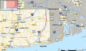
Map of eastern Connecticut with Route 12 highlighted in red | ||||
| Route information | ||||
| Maintained by ConnDOT | ||||
| Length: | 54.46 mi[1] (87.64 km) | |||
| Existed: | 1922 – present | |||
| Major junctions | ||||
| South end: |
| |||
| North end: |
| |||
| Location | ||||
| Counties: | New London, Windham | |||
| Highway system | ||||
| ||||

Connecticut Route 12 is a state highway that runs between Groton and the state line in Thompson.
History
Route 12 was preceded by New England Interstate Route 12. The southern terminus of NE-12 was originally at New London, Connecticut. It travelled along present-day Route 32 (along the west bank of the Thames River) from New London to Norwich, Connecticut. In 1932, when Connecticut decommissioned its New England Routes, Route 12 swapped places with Route 32 south of Norwich. From Norwich to the Massachusetts border, Route 12 still follows its 1920s alignment.
Route description
Route 12 from Groton to Norwich is a primary route, serving the Naval Submarine Base New London and is known as the U.S. Submarine Veterans Memorial Highway. North of Norwich, Route 12 is a minor road closely paralleling Interstate 395. Route 12 goes through the following towns: Groton, Ledyard, Preston, Norwich, Lisbon, Griswold, Canterbury (0.14 miles only), Plainfield, Killingly, Putnam, and Thompson.
Route 12 interstate
From Ct-12's northern terminus at Thompson, travellers may follow Massachusetts Route 12, New Hampshire Route 12 and Vermont Route 12 along the path of the 1920s New England Interstate Route 12. The four-state series of State Route 12s form a 283.3-mile (455.9 km) route to Morrisville, Vermont.
Junction list
| County | Location | mi | km | Destinations | Notes | ||
|---|---|---|---|---|---|---|---|
| New London | Groton | 0.0 | 0.0 | ||||
| 0.11 | 0.18 | I-95 Exit 85 | |||||
| 0.22 | 0.35 | ||||||
| Ledyard | 6.86 | 11.04 | |||||
| Preston | 9.08 | 14.61 | Western terminus of CT 2A overlap | ||||
| 9.38 | 15.10 | Eastern terminus of CT 2A overlap | |||||
| Norwich | 12.12 | 19.51 | Western terminus of CT 2 overlap | ||||
| 12.43 | 20.00 | Eastern terminus of CT 2 overlap | |||||
| 15.19 | 24.45 | ||||||
| Lisbon | 19.62 | 31.58 | I-395 Exits 21 A-B | ||||
| 20.43 | 32.88 | Western terminus of CT 138 overlap | |||||
| Griswold | 20.82 | 33.51 | Eastern terminus of CT 138 overlap | ||||
| 21.05 | 33.88 | ||||||
| Windham | Plainfield | 27.50 | 44.26 | Western terminus of CT 14A overlap | |||
| 27.91 | 44.92 | ||||||
| 30.31 | 48.78 | ||||||
| 30.59 | 49.23 | Western terminus of CT 14 overlap | |||||
| 32.12 | 51.69 | ||||||
| Killingly | 36.15 | 58.18 | Eastern terminus of US 6 overlap | ||||
| 36.51 | 58.76 | Western terminus of US 6 overlap | |||||
| 39.46 | 63.50 | ||||||
| 42.04 | 67.66 | ||||||
| Putnam | 45.58 | 73.35 | Western terminus of US 44 overlap | ||||
| 46.02 | 74.06 | ||||||
| 46.22 | 74.38 | Eastern terminus of US 44 overlap | |||||
| Thompson | 48.17 | 77.52 | |||||
| 48.88 | 78.66 | I-395 Exit 49, partial interchange | |||||
| 49.88 | 80.27 | ||||||
| 51.95 | 83.61 | ||||||
| 54.46 | 87.64 | Continues into Webster as MA 12 | |||||
| 1.000 mi = 1.609 km; 1.000 km = 0.621 mi | |||||||
References
External links
![]() Media related to Connecticut Route 12 at Wikimedia Commons
Media related to Connecticut Route 12 at Wikimedia Commons