Cornland, Illinois
"Cornland" redirects here. For the community in Missouri, see Cornland, Missouri.
| Cornland | |
| CDP | |
| Country | United States |
|---|---|
| State | Illinois |
| County | Logan |
| Elevation | 598 ft (182.3 m) |
| Coordinates | 39°56′14″N 89°24′08″W / 39.93722°N 89.40222°WCoordinates: 39°56′14″N 89°24′08″W / 39.93722°N 89.40222°W |
| Area | 0.095 sq mi (0.25 km2) |
| - land | 0.095 sq mi (0 km2) |
| - water | 0 sq mi (0 km2), 0% |
| Population | 93 (2010) |
| Density | 978.9/sq mi (378.0/km2) |
| Timezone | CST (UTC-6) |
| - summer (DST) | CDT (UTC-5) |
| Postal code | 62519 |
|
Location of Cornland within Illinois
| |
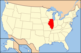
 Location of Illinois in the United States
| |
Cornland is an unincorporated census-designated place in Logan County, Illinois. As of the 2010 census, its population was 93.[1]
History
Cornland was laid out and platted in 1871 when the Gilman, Clinton & Springfield Railroad was extended to that point.[2] A post office called Cornland has been in operation since 1872.[3]
Geography
The town of Cornland lies on the rolling flat land of the Sangamon River drainage area situated near the bottom grounds of Lake Fork Creek.
References
- ↑ "American FactFinder". U.S. Census Bureau. Retrieved 9 March 2011.
- ↑ Stringer, Lawrence Beaumont (1911). History of Logan County, Illinois: A Record of Its Settlement, Organization, Progress, and Achievement. Unigraphic. p. 633.
- ↑ "Logan County". Jim Forte Postal History. Archived from the original on 15 September 2005. Retrieved 16 January 2016.
External links
This article is issued from Wikipedia - version of the 12/1/2016. The text is available under the Creative Commons Attribution/Share Alike but additional terms may apply for the media files.