Cyclone Glenda
| Category 5 severe tropical cyclone (Aus scale) | |
|---|---|
| Category 4 (Saffir–Simpson scale) | |
 Cyclone Glenda near peak intensity | |
| Formed | 23 March 2006 |
| Dissipated | 31 March 2006 |
| Highest winds |
10-minute sustained: 205 km/h (125 mph) 1-minute sustained: 220 km/h (140 mph) Gusts: 295 km/h (185 mph) |
| Lowest pressure | 910 hPa (mbar); 26.87 inHg |
| Fatalities | None reported |
| Damage | $965,000 (2006 USD) |
| Areas affected | Australia |
| Part of the 2005–06 Australian region cyclone season | |
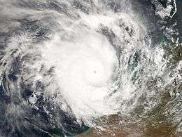
Severe Tropical Cyclone Glenda (JTWC designation: 20S, also known as simply Cyclone Glenda) of March 2006 was among the strongest tropical cyclones to threaten Western Australia, though it weakened considerably before landfall and moved ashore in a lightly populated region. It began as a tropical low on 15 March in the Gulf of Carpentaria. The precursor disturbance drifted over Top End and later across the northeastern portion of Western Australia, and after emerging into the Indian Ocean it strengthened into a tropical storm. Aided by favourable environmental conditions, Glenda rapidly intensified to reach Category 5 status on the Australian cyclone scale, and with a peak intensity of 910 mbar it was among the strongest cyclones on record within the Australia region. On 30 March it moved ashore near Onslow as a Category 3 cyclone, and the next day it degenerated into a remnant tropical low over land.
The precursor disturbance produced heavy rainfall in the Kimberley region of Western Australia, causing record flooding and some road damage. Minor damage was reported at the final landfall of Glenda. Due to the sparse population and preparations made, the cyclone was not responsible for any deaths or injuries. However, its name was later retired from the list of tropical cyclone names.
Meteorological history

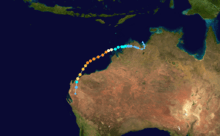
On 15 March, a tropical disturbance developed in the south-western Gulf of Carpentaria. It moved westward, drifting across Top End, and it exited into the Joseph Bonaparte Gulf on 22 March.[1] The Bureau of Meteorology (BoM) office in Darwin, which is the local Tropical Cyclone Warning Centre, began issuing advisories on the system late on 23 March while it was located about 85 km (50 mi) east-south-east of Wyndham, Western Australia. Environmental conditions favored intensification as an anticyclone developed over the storm, which provided good outflow and low vertical wind shear. Initially, the primary inhibiting factor was land interaction.[2] After executing a small loop over water, the disturbance continued westward, crossing over the northern portion of Western Australia before emerging into the Indian Ocean on 26 March.[3] It began tracking west-southwestward just offshore of the Kimberley coastline, and its convection quickly concentrated. At 0000 UTC on 27 March, the Joint Typhoon Warning Center (JTWC) classified it as Tropical Cyclone 20S. Three hours later, the BoM office in Perth upgraded the storm to Tropical Cyclone Glenda about 260 km (160 mi) north of Derby, Western Australia.[2]
Upon reaching open waters, Glenda quickly intensified, and midday on 27 March the BoM upgraded it to tropical cyclone status, or the equivalence of a minimal hurricane.[2] Shortly thereafter, the JTWC followed suit by upgrading it to cyclone status just 12 hours after first warning on the storm.[4] A wind gust of 113 km/h (70 mph) was reported on Adele Island as the cyclone passed nearby.[1] The track turned south westward around a steering ridge over Australia, aided by a mid-latitude trough. By 27 March, Glenda had developed a banding eye, and subsequently began rapid deepening, with warm water temperatures of over 30 °C (86 °F) and a very favourable upper-level environment.[4] At 1200 UTC on 28 March, the JTWC classified Glenda with peak winds of 260 km/h (160 mph) about 235 km (145 mi) west-north-west of Broome, or about 455 km (280 mi) north-north-east of Port Hedland;[4] however, in a subsequent analysis, the JTWC lowered their intensity estimate to 220 km/h (140 mph).[5] At the same time the BoM estimated the cyclone attained peak winds of 215 km/h (135 mph) with gusts to 300 km/h (185 mph), or a Category 5 on the Australian cyclone scale.[3] Its peak intensity of 910 mbar was tied for the fifth most intense tropical cyclone on record in the Australian basin.[6]
Initially, Cyclone Glenda was forecast to intensify further. However, a gradual increase in vertical shear caused the eye to become disorganised,[4] with land interaction contributing to further weakening. The BoM maintained Glenda as a Category 5 cyclone until 29 March,[3] and initially it was forecast to turn southward to move ashore near the populated region of Karratha at high tide.[7] It retained its south west track and passed over several weather stations, one of which recorded sustained winds of 176 km/h (109 mph).[1] Glenda made landfall near the less populated town of Onslow at around 10pm WST (1400 UTC) on 30 March.[8] The cyclone had weakened to a marginal Category 3 at the time of landfall.[8] The JTWC issued its final warning on Glenda shortly after it moved ashore. The cyclone turned south and south-south-eastward and rapidly weakened over land in an area of increasing wind shear, and early on 31 March the BoM downgraded Glenda to a tropical low.[2]
Preparations, impact and aftermath
| Rank | Cyclone | Year | Min. pressure |
|---|---|---|---|
| 1 | Gwenda | 1999 | 900 hPa (26.58 inHg) |
| Inigo | 2003 | ||
| 3 | George | 2007 | 902 hPa (26.64 inHg) |
| 4 | Orson | 1989 | 904 hPa (26.70 inHg) |
| 5 | Theodore | 1994 | 910 hPa (26.87 inHg) |
| Vance | 1999 | ||
| Fay | 2004 | ||
| Glenda | 2006 | ||
| Source: Australian Bureau of Meteorology | |||

The precursor system dropped heavy rainfall on 23 March in the eastern Kimberley in the state of Western Australia. The rainfall led to record flooding in the area; the flooding washed out several roads near Kununurra, including a portion of the Great Northern Highway. Six people were evacuated due to the flooding.[9]
Offshore, the threat of Glenda prompted officials to close oil, representing a lack of production of 154,000 barrels of oil. Additionally, natural gas fields were closed, and several ports along the coastline were shut down during the passage of the storm.[10] Prior to the storm's landfall, officials issued a Red Alert for several communities. Storm shelters were opened in Karratha and Onslow,[9] while a few hundred people evacuated along the coastline.[11]
Glenda made landfall near Onslow, where sustained winds reached 117 km/h (72 mph). There, the storm produced a 24‑hour rainfall total of 206 mm (8.11 in), which is the sixth greatest daily precipitation on record in the town. Several other locations reported over 200 mm (8 in), though overall precipitation was less than a usual landfalling tropical cyclone.[1] The rainfall flooded several roads.[9] The winds downed several trees and power lines,[12] which left about 2,000 people in Karratha without electricity;[11] the power outage was quickly repaired.[12] Several windows at the hospital in Onslow were broken, resulting in some minor water damage.[12] Overall damage was minor,[3] and no deaths or injuries were reported,[12] which was credited to the storm's weakening and preparations in the landfall area.[3] In all, damages from the storm amounted to A$1.2 million (US$965,000).[13] The disruption to shipping companies resulted in economic losses of A$30 million (US$24.1 million).[14] Oil companies reported a loss of 500 tonnes during the economic quarter due to the cyclone.[15] The Onslow Salt company reported upwards of A$20 million (US$16 million) in lost revenue.[13]
Following the storm, residents and companies affected by the storm were allowed to file insurance claims. About A$240,000 (US$193,000) was filed in repair claims for council buildings and A$69,000 (US$55,000) in airport insurance. About A$99,000 (US$79,000) and A$300,000 (US$241,000) was provided in financial support for television and broadcasting infrastructure and aerodrome infrastructure respectively.[13]
The Bureau of Meteorology retired the name Glenda following its usage.[16]
See also
References
- 1 2 3 4 "Significant Weather — March 2006" (PDF). Bureau of Meteorology. 2006. Retrieved 13 April 2008.
- 1 2 3 4 Gary Padgett (2006). "March 2006 Worldwide Tropical Cyclone Summary". Australia Severa Weather. Retrieved 13 April 2008.
- 1 2 3 4 5 Western Australian Regional Office (2006). "Severe Tropical Cyclone Glenda". Bureau of Meteorology. Retrieved 13 April 2008.
- 1 2 3 4 Joint Typhoon Warning Center (2006). "Warnings on Cyclone Glenda". Australia Severe Weather. Retrieved 13 April 2008.
- ↑ Joint Typhoon Warning Center (2007). "Best Track for Cyclone Glenda". United States Navy. Retrieved 26 September 2008.
- ↑ "Australian Region Best Track 1907-2006" (Zip). Bureau of Meteorology. 2006. Retrieved 4 November 2007.
- ↑ "WA Tropical Cyclone Season Summary 2005-06". Bureau of Meteorology. 2006. Retrieved 14 April 2008.
- 1 2 "Severe Tropical Cyclone Glenda" (PDF). Perth Tropical Cyclone Warning Centre. Bureau of Meteorology. Retrieved 6 January 2013.
- 1 2 3 Fire and Emergency Services Authority (2007). "2005-06 Cyclones in Western Australia" (PDF). Archived from the original (PDF) on 20 July 2008. Retrieved 2008-04-15.
- ↑ Bloomberg (29 March 2006). "Cyclone Glenda Shuts Ports, Oil Fields in Australia". Retrieved 2008-04-15.
- 1 2 Impact Forecasting (2006). "Annual Global Climate and Catastrophe Report: 2006" (PDF). Retrieved 2008-04-15.
- 1 2 3 4 Australian Associated Press (31 March 2006). "Pilbara unscathed by cyclone Glenda". The Age. Melbourne. Retrieved 2008-04-15.
- 1 2 3 Shire of Ashburton (19 June 2007). "Ordinary Council Meeting". Archived from the original (PDF) on 25 July 2008. Retrieved 2009-06-10.
- ↑ Staff Writer (30 March 2006). "Cyclone Glenda makes landfall". ABC News. Retrieved 2009-06-10.
- ↑ Staff Writer (26 April 2006). "Activities Report for the Period Ended 31 March 2006" (PDF). Minara Resources Limited. Retrieved 2009-06-10.
- ↑ Bureau of Meteorology (2008). "Tropical Cyclone Names". Retrieved 2008-04-15.
External links
 Media related to Cyclone Glenda at Wikimedia Commons