Datu Paglas, Maguindanao
| Datu Paglas | |
|---|---|
| Municipality | |
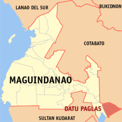
 Map of Maguindanao showing the location of Datu Paglas | |
.svg.png) Datu Paglas Location within the Philippines | |
| Coordinates: 6°46′1″N 124°51′0″E / 6.76694°N 124.85000°ECoordinates: 6°46′1″N 124°51′0″E / 6.76694°N 124.85000°E | |
| Country |
|
| Region | Autonomous Region in Muslim Mindanao (ARMM) |
| Province | Maguindanao |
| Founded | November 22, 1973 |
| Barangays | 23 |
| Government[1] | |
| • Mayor | Mohamad P. Paglas |
| Area | |
| • Total | 132.10 km2 (51.00 sq mi) |
| Population (2010) | |
| • Total | 20,290 |
| • Density | 150/km2 (400/sq mi) |
| Time zone | PST (UTC+8) |
| ZIP code | 9617 |
| Dialing code | +63 (0)64 |
| Income class | 4th |
Datu Paglas is a 4th class municipality in the province of Maguindanao, Philippines. According to the 2010 census, it has a population of 20,290 people in 4,497 households.
Barangays
Datu Paglas is politically subdivided into 23 barangays.[2]
- Alip (Pob.)
- Bonawan
- Bulod
- Damalusay
- Damawato
- Datang
- Elbebe
- Kalumenga (Kalumanga)
- Katil
- Lipao
- Lomoyon
- Madidis
- Makat
- Malala
- Mangadeg
- Manindolo
- Mao
- Napok
- Palao sa Buto
- Poblacion
- Puya
- Salendab
- Sepaka
History
Datu Paglas was created out of 7 northern barrios of the municipality of Columbio on November 22, 1973, by Presidential Decree No. 340.[3] While Columbio was made part of the province of Sultan Kudarat, Datu Paglas was made part of the province of Maguindanao.[4]
Demographics
| Population census of Datu Paglas | ||
|---|---|---|
| Year | Pop. | ±% p.a. |
| 1990 | 13,970 | — |
| 1995 | 15,522 | +1.99% |
| 2000 | 20,014 | +5.60% |
| 2007 | 29,979 | +5.73% |
| 2010 | 20,290 | −13.24% |
| Source: National Statistics Office[5] | ||
References
- ↑ "Official City/Municipal 2013 Election Results". Intramuros, Manila, Philippines: Commission on Elections (COMELEC). 1 July 2013. Retrieved 5 September 2013.
- ↑ National Statistical Coordination Board. "PSGC Interactive: Municipality/City: DATU PAGLAS". Retrieved 2008-05-19.
- ↑ Chan Robles Virtual Law Library (1998-07-19). "Presidential Decree No. 340". Retrieved 2008-05-19.
- ↑ Chan Robles Virtual Law Library (1998-07-19). "Presidential Decree No. 341". Retrieved 2008-05-18.
- ↑ "Total Population by Province, City, Municipality and Barangay: as of May 1, 2010". 2010 Census of Population and Housing. National Statistics Office. Retrieved 6 October 2013.
External links
- Philippine Standard Geographic Code
- Philippine Census Information
- Local Governance Performance Management System
 |
Tulunan, Cotabato |  | ||
| Pandag Mangudadatu |
|
Tulunan, Cotabato Columbio, Sultan Kudarat | ||
| ||||
| | ||||
| Lutayan, Sultan Kudarat | Columbio, Sultan Kudarat |
This article is issued from Wikipedia - version of the 11/1/2016. The text is available under the Creative Commons Attribution/Share Alike but additional terms may apply for the media files.